|
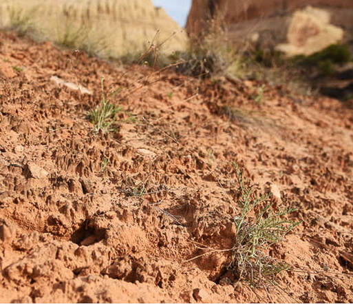
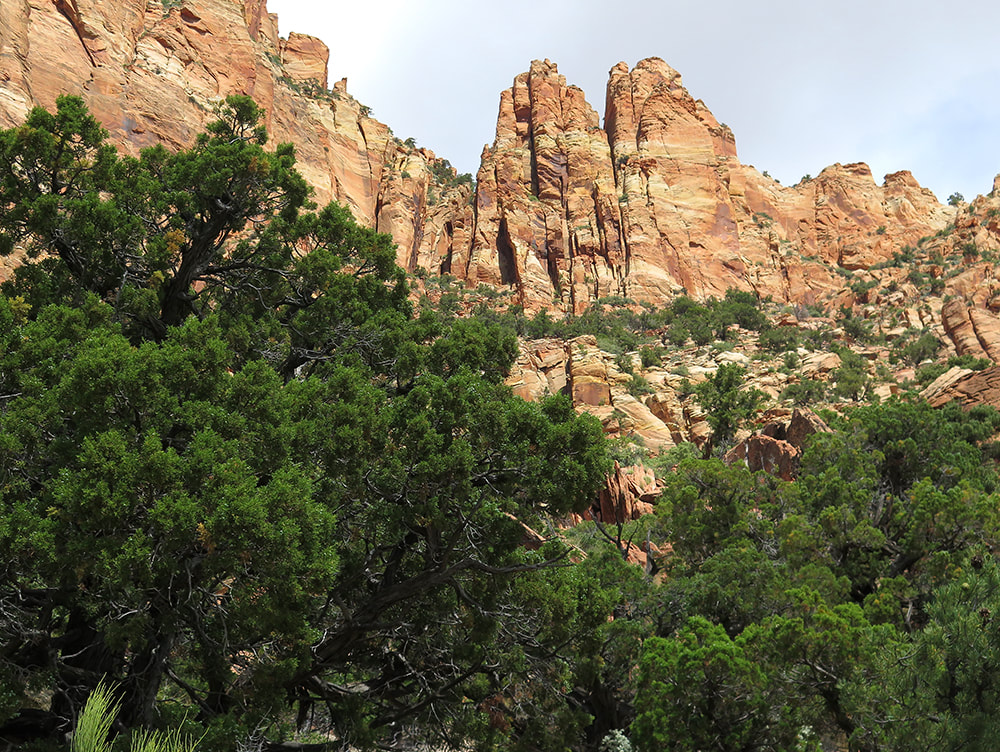
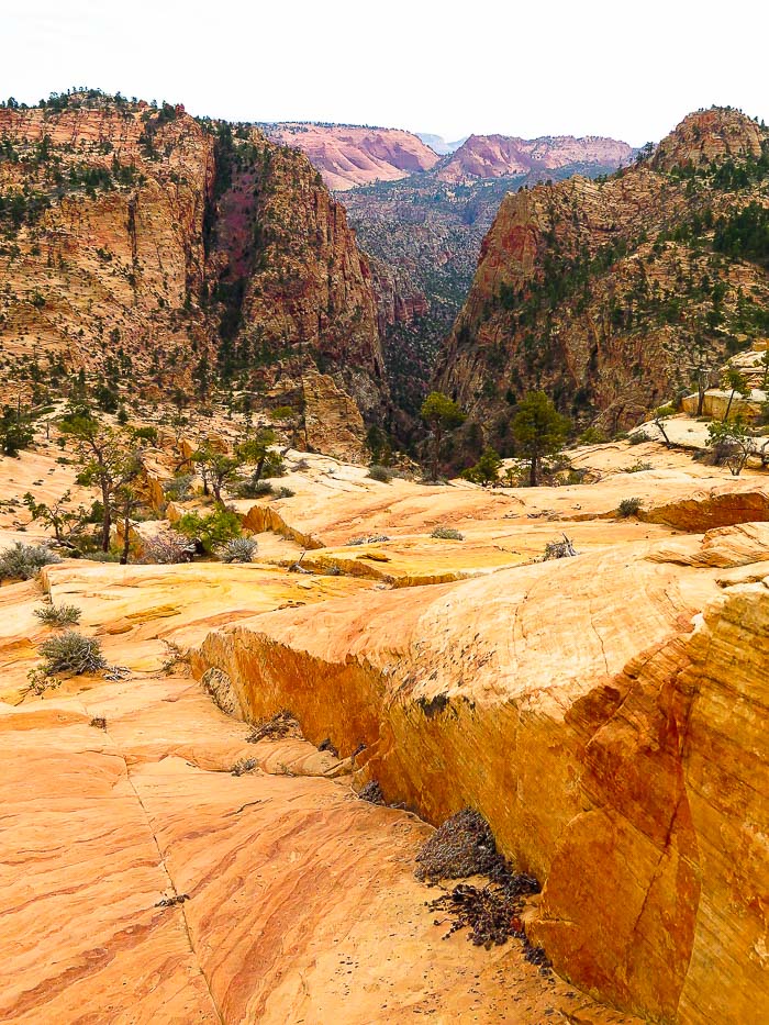
Our attempt at a relentless 3,500-foot gain, sections of Class 3-4 climbing, and route-finding journey under cliffs and over ridges make this fabled summit complete with petroglyphs elusive for now. I recommend this tough, extraordinary hike even if you don't intend on summiting. But do your research first. Related: Utah Mountain Biking: The Cowbell and the Cryptobionic Highway (cryptobiotic crusts) Angels Landing in Zion: Not for the Faint of Heart Southern Utah Hiking and Biking in a Pandemic: Zion, Wire Mesa, and Snow Canyon Canaan Mountain via Squirrel Canyon Red Mountain Primitive Trail - St. George Desert Plant photos 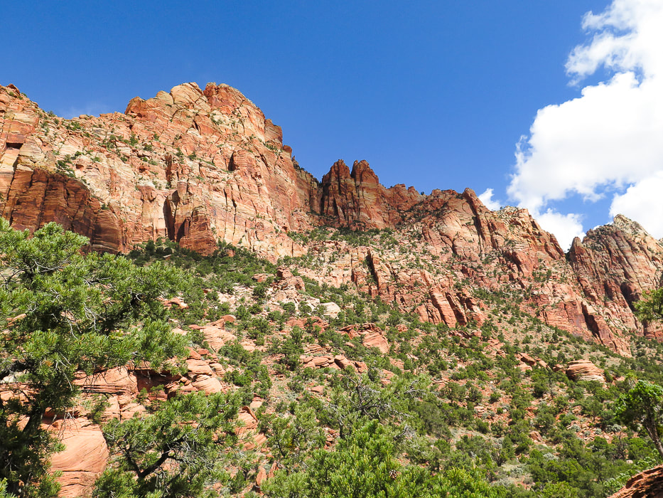 East cliff face below Mt. Kinesava. Summit cannot be seen from this vantage point. Route goes through trees at base of cliffs in shadow, then up to the right following trees to notch. After this, still hundreds of feet climb to summit.
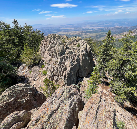
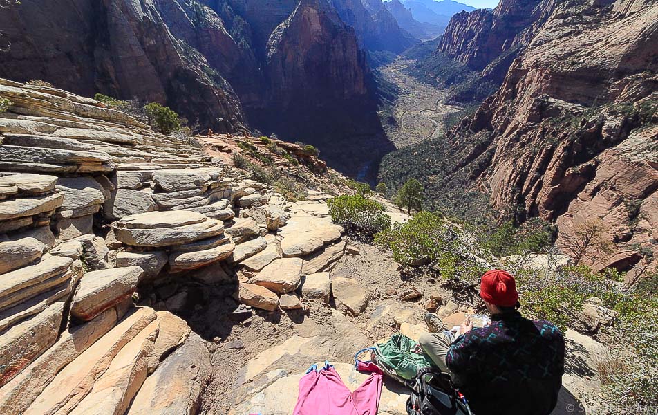
Our Hike Fred and I decided to hike Mt. Kinesava when we saw it towering over the southern entrance to Zion National Park while riding on the Wire Pass Trail near Springdale, Utah. When we finally had a cool day during a more recent hike/bike vacation, we gave it a try. Even though we didn't make it, this mountain is one of the most memorable I have ever hiked. Majestic Mt. Kinesava remains elusive, invincible, its petroglyphs unreachable, at least to us. A grudge peak. Kinesava is more than a hike, it's an experience. The view of red and orange cliffs and pinnacles that tower the more you climb, the increasingly spectacular views of Zion Canyon behind you and the ever-shrinking town of Springdale below create a unique "surround-view" experience of being "perched" for hours. Kinesava's refusal to let just anyone walk on her summit may be the reason why Native Americans chose this place to carve petroglyphs on the mesa just above these challenging rock walls. Landmarks in Zion, like Mt. Kinesava and Sinawava are named after Paiute deities. You have to do your homework for this cross-country hike, but there are few summit reports available. There is a break in the cliff band that surrounds Kinesava's base created by an apparent old landslide where you can enter the terrain that will take you up to the cliffs. You must catch this same entry point on your exit, so a good idea to look back to note where this is by looking at landmarks. Rock cairns mark faint trails, but it seems like you usually find these more often on the way down. Cairns left by previous hikers were helpful in the Class 3-4 sections. For a more detailed hike description, click on "Trip Stats" above. You have to navigate over three ridges before you get to the base of the sheer walls, where you scramble and climb across narrow sections of the cliff in a horizontal/diagonal direction following the line of trees. Here, the climb is Class 3 (climbing with use of hands) up more or less vertical rocks, making your way to the right along cliff base. Where we reached too much exposure (Class 4), we backtracked to find a safer route. It took us longer than we wanted to navigate through the horizontal band of trees under the pinnacled vertical cliffs. We reached a comfortable platform with a good view of the "catwalk", a very narrow section that must be traversed to gain access to the final climb up the diagonal band of trees to the notch that lands you on the plateau above. This is where we stopped; it looked pretty difficult and we didn't have enough time to summit AND get down (see image below). Once on the plateau, Mt. Kinesava's summit is another 300-400 foot climb. (See our GPS tracks below).  Zion Canyon from east face of Mt. Kinesava  Mt. Kinesava from Chinle Trail (on a different hike) 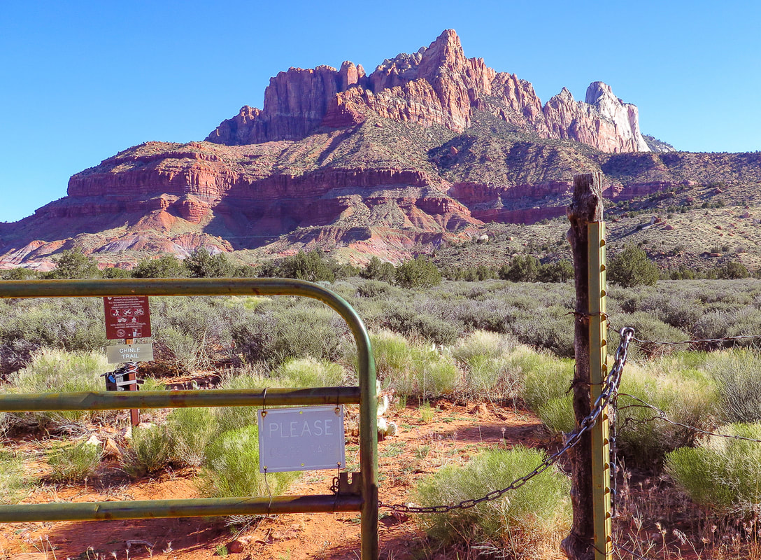 Looking at east face of Mt. Kinesava in the morning. The summit is just behind the largest prominence, mostly hidden from this view. Gate, 1.1 miles from Chinle Trailhead marks Zion National Park boundary. Chinle trail continues to the left. The route goes up the fan-shaped debris slide through the trees, continuing through trees to right of prominence up to notch. 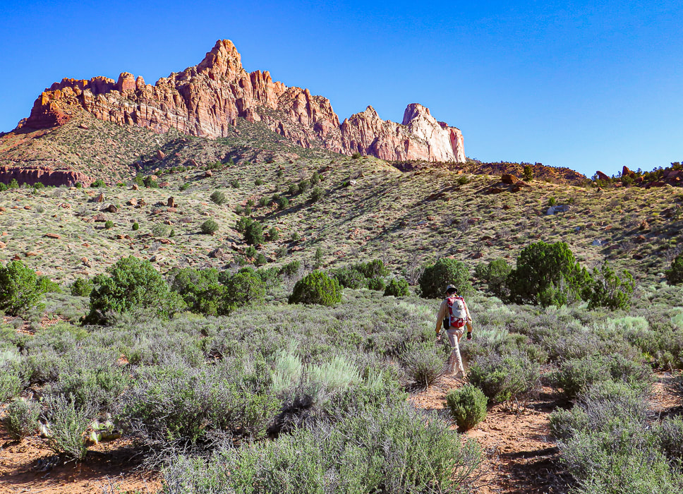 First set of Ridges just after Zion NP Boundary Heading cross-country towards 3 main lower ridges. We went up the ridge to the right in the photo. 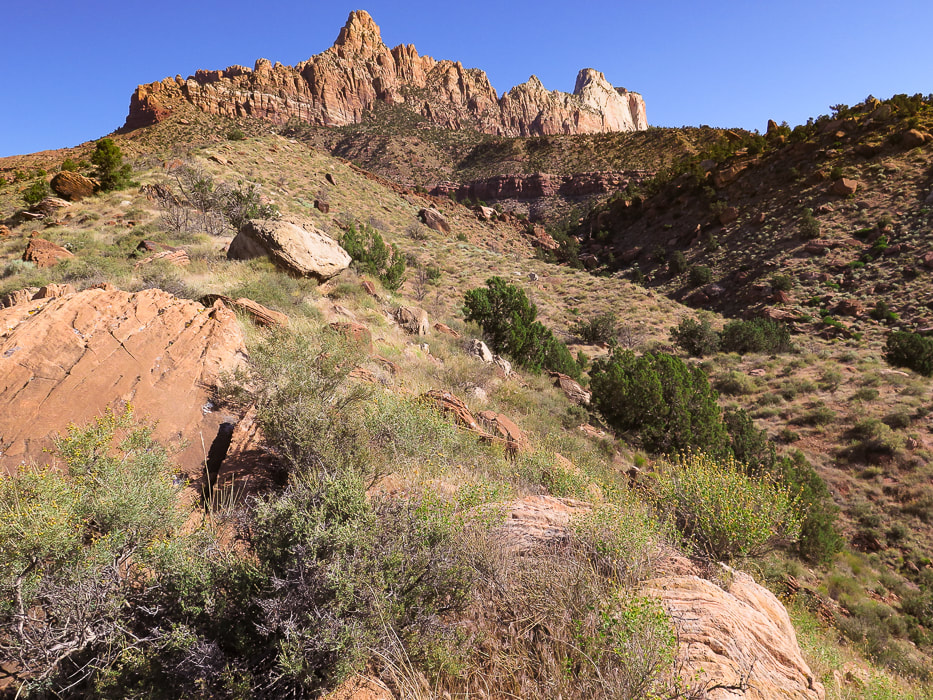 We ascended the left (west) ridge, and descended the right (middle) ridge on the way back. At the top of the ridge to the right is a trail and the 3 telephone poles at entry through break in cliff band to arrive at plateau above cliff. I would ascend via the right ridge next time. 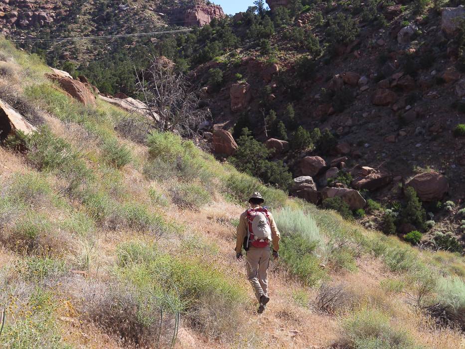 We had to lose some elevation and side-hill the left ridge into the small canyon. Aim for the telephone wires and 3 large poles on middle ridge saddle just under passage through cliff band. 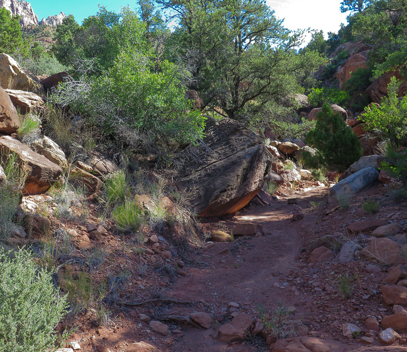 Small canyon between left and middle ridges. After descending from west, or left ridge into this canyon, it took us right up to saddle with 3 telephone poles. 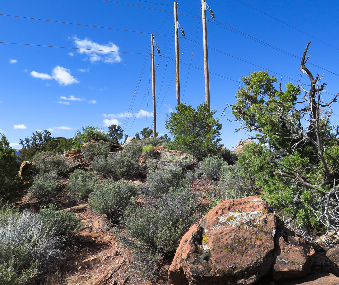 Aim for three telephone poles at base of trail that goes through cliff break landslide. On our way back down, we stayed on the ridge that these poles are on, to the right of this image (the "middle" ridge). 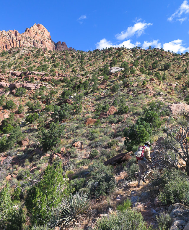 Second Ridge Rock slide over bottom cliff base is entry/exit onto plateau above. Defined trail here. 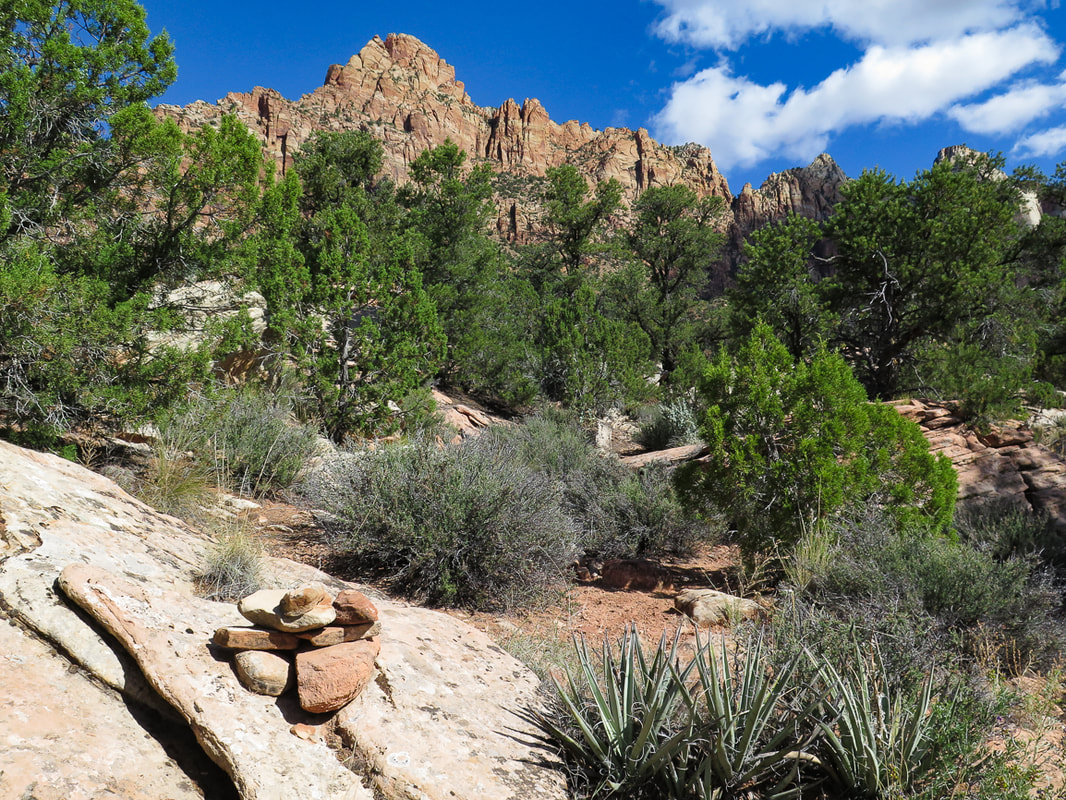 Cairn that marks entry from steep second ridge through lower cliffs to plateau above. These white rocks can be seen above to aim for on the way down off the plateau.
 Third Ridge Approaching horizontal band of trees under sheer cliffs 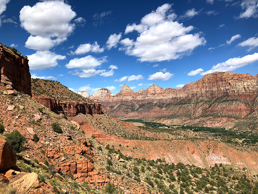 Everywhere you look, it's spectacular! Zion Canyon 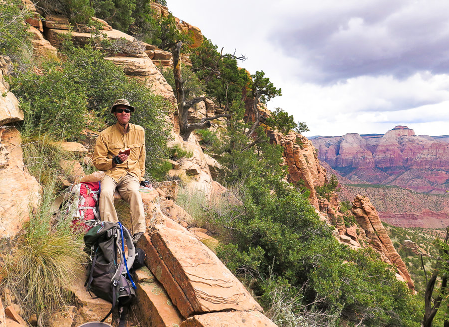 Reached horizontal band of trees for a cliffside lunch - Zion Canyon view. 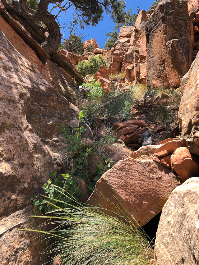 Fun "passageway" to to get to vertical rocks 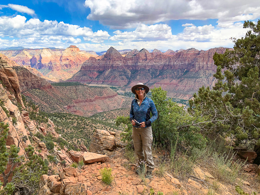 Zion Canyon from cliffs of Mt. Kinesava - 6,400 feet Keep on Exploring - Never Stop Climbing Mountains! 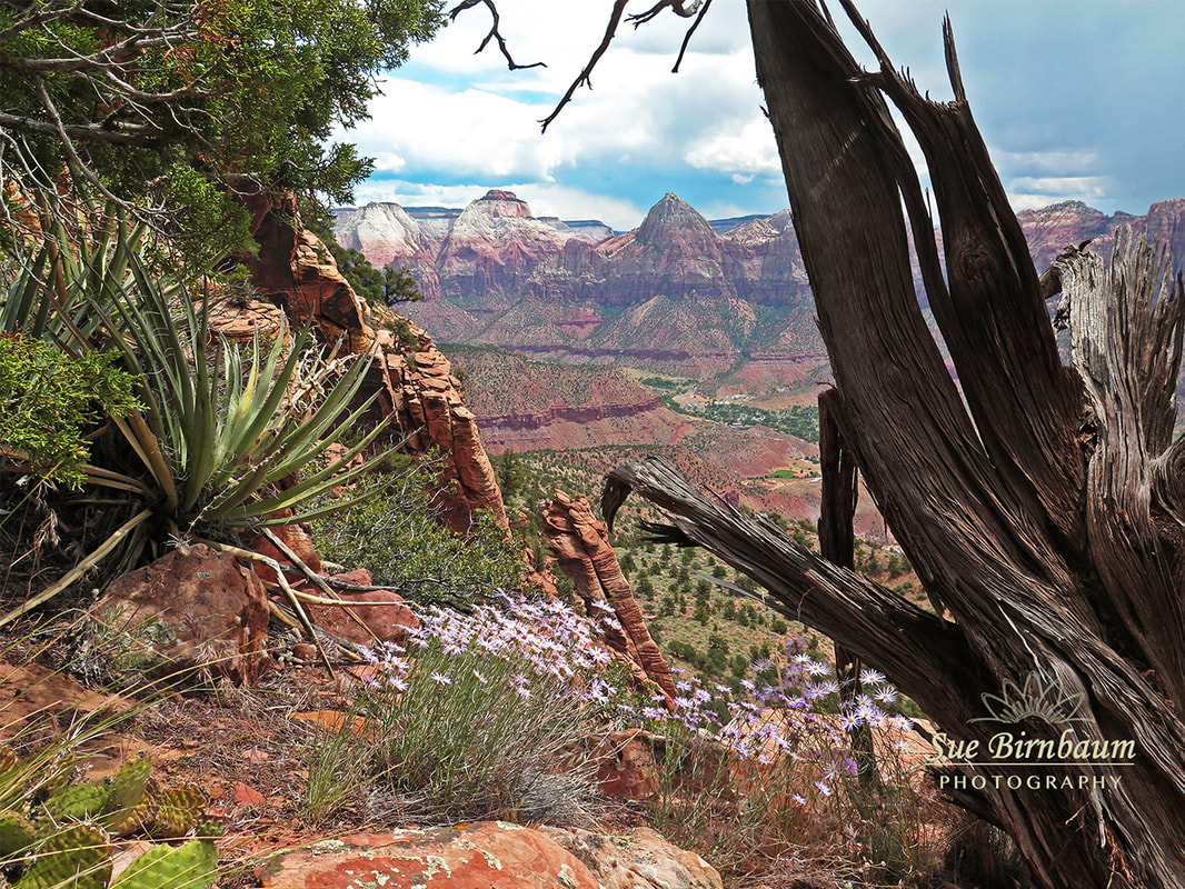 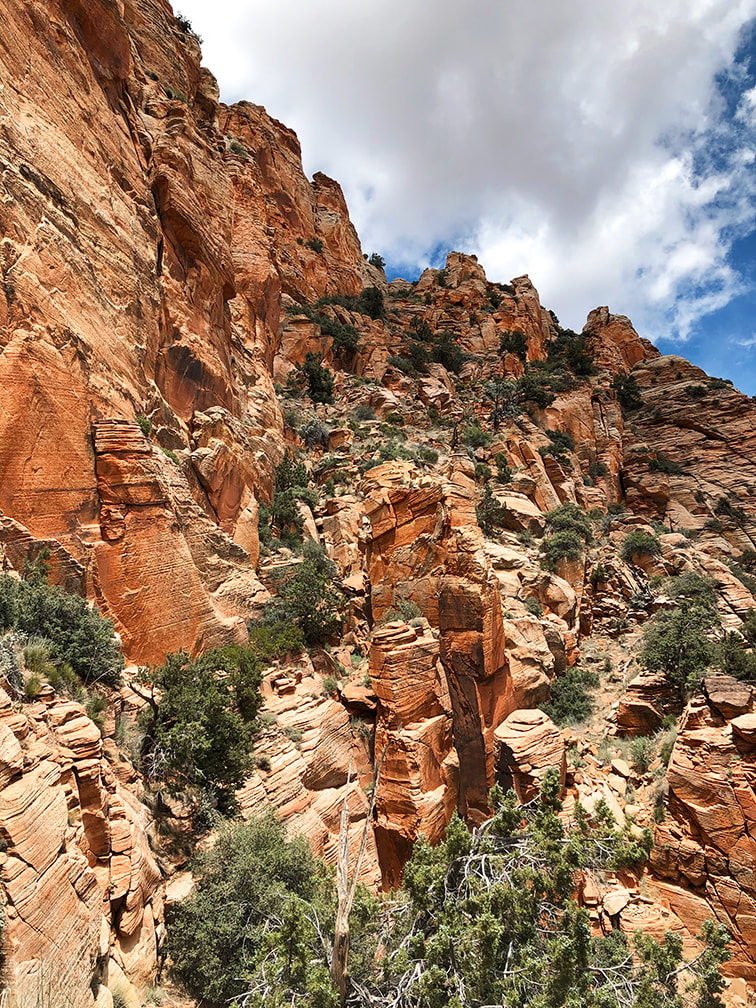 This is where we stopped. Trail continues through trees on far left, over the "catwalk" and up through trees to notch. The Way Down The view of the cliff-hugging narrow "catwalk" and vertical rock towers is intimidating. It's a different feeling entirely as I sit here at my desk writing this post, where I am not facing this astonishing scene of exposed walls and loose rocks to climb - it's easy to think now I can do it. Edward Abbey, in his book Desert Solitaire said that Southern Utah "is the most beautiful place on earth." My words don't do justice when describing what it's like to hike in this extraordinary place, where all natural elements seem to fit almost magically together. The orange and green, the soft sand and the hard cross-bedded rocks, the cliffs and the undulating lowlands and streams. The expansive desert with steep mesas standing like platforms under a wide sky. Places to rest and absorb the views among imposing and rugged terrain. Prickly cacti and slender, waving penstemon. We caught a defined trail on the way down that took us a bit too far to the west. The most important thing to remember is to aim for the large white boulders on the edge of plateau; it's your exit point to the ridges below. Hopefully next time I attempt this hike, we will be able to conquer this section, see the petroglyphs on the plateau above, and summit. I already feel lucky to be able to see these sights that not many others have seen before, and to be able to hike with my husband. We have fun! Life is really good. "Freedom begins between the ears." - Edward Abbey, environmental advocate and author of Desert Solitaire 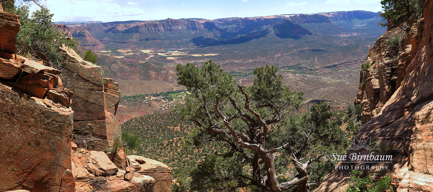 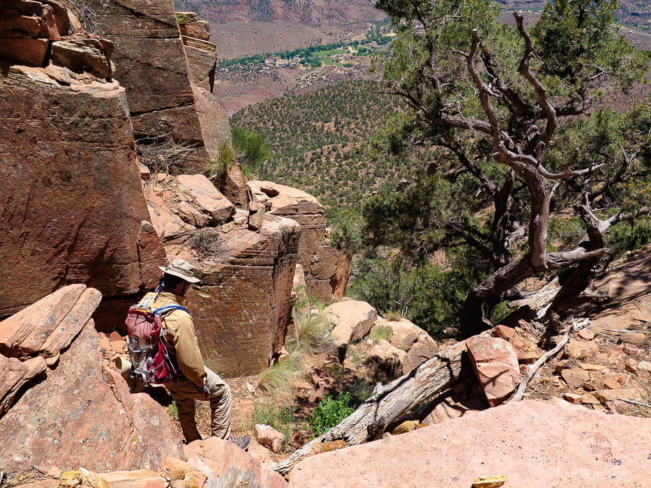 Heading down! 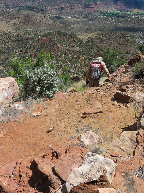 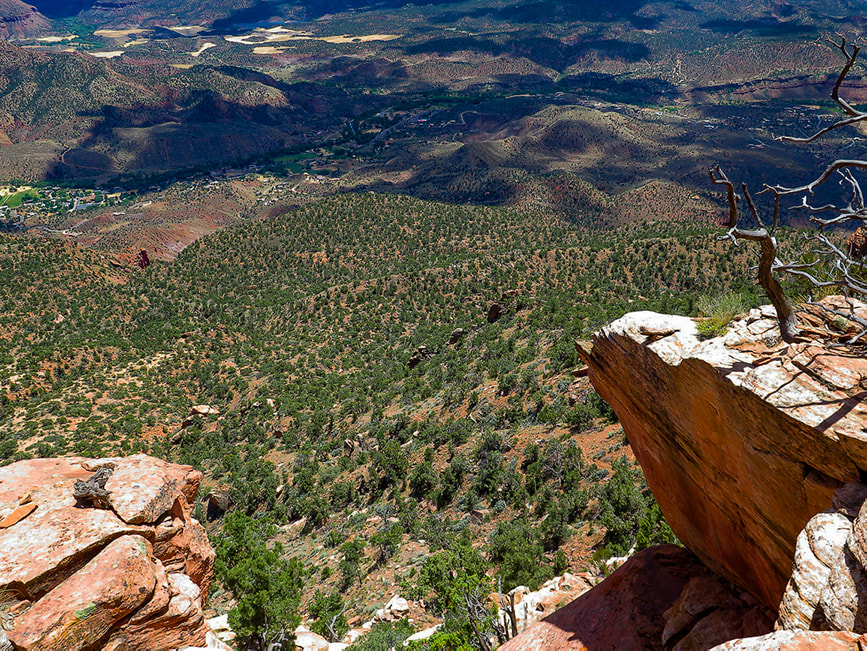 Heading off cliffs onto "third ridge". Springdale, Utah below in river bottom with Virgin River "Our updated trailhead will add 2 hours to the trip, which means that now fewer of you should ever attempt it. DO NOT GET STUCK ON THIS ROUTE IN THE DARK!!!!!"
- zionnational-park.com Trip Stats
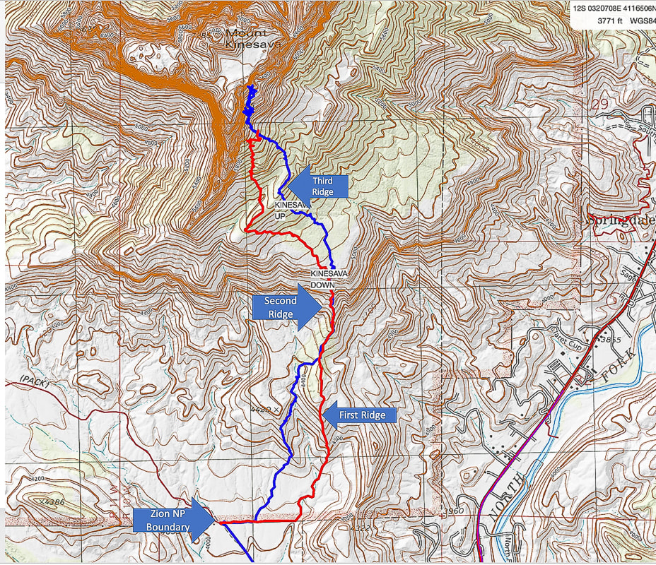 Our route up (blue) and route down (red) Bottom of map shows approach to Zion National Park boundary fence via Chinle Trail (Trailhead on Utah State 9 Highway just before Springdale). I recommend using the ridge that the red trail traverses just after fenceline. 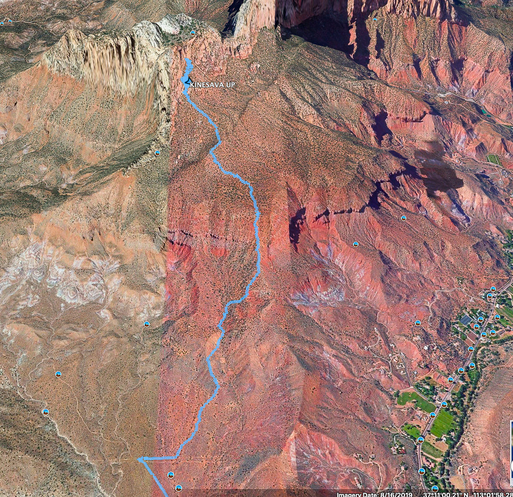 Google Earth image of our hike up after crossing Zion NP boundary fence To avoid losing elevation on the way up, better to take the ridge to the right (east) of the one we took up. This leads up to only break in the cliffs that surround the bottom. Town of Springdale at lower right. References
Chesher, Greer K. Zion Canyon: A Storied Land. 2007. The University of Arizona Press. Quarnstrom, Evan. Zion National Park: Tackling Mt. Kinesava. Website: Evan Quarnstrom: Stories of Travel and Adventure. The Hiker's Code: Brush Up on Trail Etiquette in Time for Hiking Season. Posted 11/5/19 on Utah.com Zion: Mt. Kinesava. Favorite Hikes In and Around Zion National Park. zionnational-park.com
3 Comments
When temperatures soar in St. George, Utah, head up to the Pine Valley Mountains to look over Southern Utah and Arizona mountains in a cool, beautiful forest with mature stands of aspens, Mountain Mahogany trees, and trails and peaks to explore. Related: Signal Peak: 10,369' - Pine Valley Mountain Wilderness Gardner Peak - Pine Valley Mountains - The Summit Less Traveled Canaan Mountain via Squirrel Canyon Angels Landing in Zion: Not for the Faint of Heart Double Arch Alcove Hike - Kolob Canyons in Zion NP 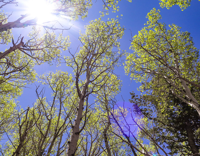 Trip Stats Location: Pine Valley Mountain Wilderness, Dixie National Forest, near St. George, Utah Distance/Elevation gain: 12.8 miles out and back/3,670'. Trailhead = 6,650', Summit = 10,320' Difficulty: Moderate - Strenuous Class 1 on Forsyth trail for 4.5 miles, Class 1 strenuous on Summit Trail; Class 2 on short spur trail to Burger Peak. Dates Hiked: May 28, 2020, July 29, 2023. Trails: Forsyth Trail #31012 to Summit Trail #31021. Maps and Apps: Trails Illustrated #702: Cedar Mtn/Pine Valley Mtn - Dixie National Forest, Utah. Note: AllTrails tracks for "Forsyth Trail to Burger Peak" go only to lookout on Summit Trail, not all the way to Burger Peak summit, which is ~ 0.25-0.3 miles from lookout. Coordinates: Forsyth Canyon Trailhead = 37.3836 -113.5068. Burger Peak = 37.3248 -113.5016 Considerations: Creek crossings shallow in late May; snow bank negotiation in shaded western-facing slopes. No permits, dogs must have strict voice control, preferably on leash. Geology: Pine Valley Mountains form the Pine Valley Laccolith, made of monzonite porphyry (intrusive igneous rock). This dome-shaped laccolith was formed when magma was injected between existing rock layers because an outlet for the magma (vent) had been closed. This is the largest laccolith in the U.S. Lakkos is greek for reservoir, lith = stone.  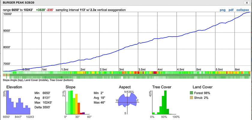 CalTopo map and elevation profile for Burger Peak, Pine Valley Mountain Wilderness, Dixie National Forest, Utah 3,670' elevation gain in 6.4 miles Trailhead in town of Pine Valley to the north, trail heads south to Burger Peak. click on map for larger image 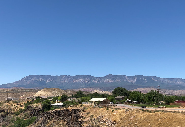 View of southern aspect of Pine Valley Mountains, the largest laccolith in the U.S., from Hurricane, Utah The highest peak is Signal Peak at 10,365 feet. 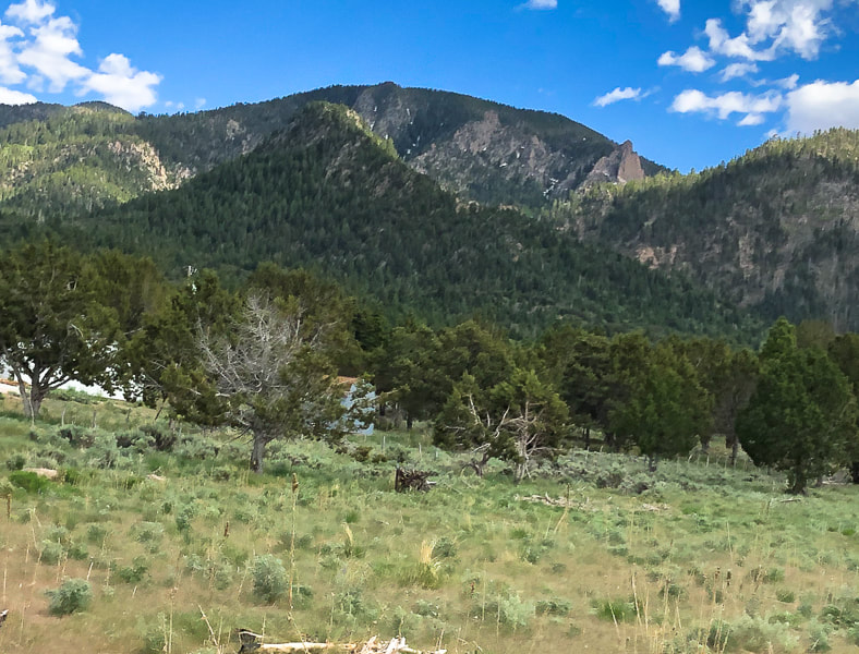 North side of Pine Valley Mountains, from town of Pine Valley, Southern Utah Forsyth trail passes by large crags Our Hike: Forsyth Trail --> Summit Trail #3021--> spur trail to Burger Peak summit Many people consider Southern Utah synonymous with slot canyons and colorful cliffs, hoodoos, and mesas. Its famous national parks - Zion, Bryce and Arches are gems with spectacular scenes. It was hot in St. George, so we headed to the cool Pine Valley Mountain Wilderness, where we summited Burger Peak to see a vast view of the hot desert below. The Pine Valley Mountains are less than an hour's drive north of St. George, and provide the forested backdrop to the little town of Pine Valley. The drive itself is beautiful, as you pass by a huge cinder cone and gorgeous Snow Canyon State Park. We felt lucky to have "stumbled" onto this wilderness, the second-largest in Utah because of the many trail and peak opportunities. It has the most diverse flora of any Utah mountain range, with ~ 1,000 species identified so far, and numerous meadows. We met a backpacker on a separate hike near Whipple Valley who said he had to go "two meadows over" for his first night. He was doing a loop trip using Summit Trail, which treks 35 miles between entry points at Whipple Valley and Forsyth trailhead, up and along highest Pine Valley Mountains ridge. The first mile wanders through large stands of mature Mountain Mahogany and Ponderosa Pines. Stream crossings over Forsyth Creek are easy, with low stream flow. This forest is so unique, because it has such a wide variety of trees. Tree dead fall on the first mile attests to destructive bark beetles that have plagued many forests throughout the west. At mile two, the trail steepens and follows Forsyth Creek as the canyon narrows. It climbs steadily for the next 4.5 miles to the peak; we ran into our first snow bank around 9,000 feet in May. A spur trail heading north from Summit Trail takes you to the peak. The view of Southern Utah from the steep cliffs at this intersection is incredible. Forsyth Creek video  First mile of Forsyth Trail   Forsyth Creek - end of July 2023. 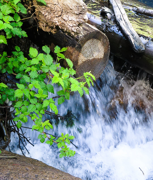 Forsyth Creek 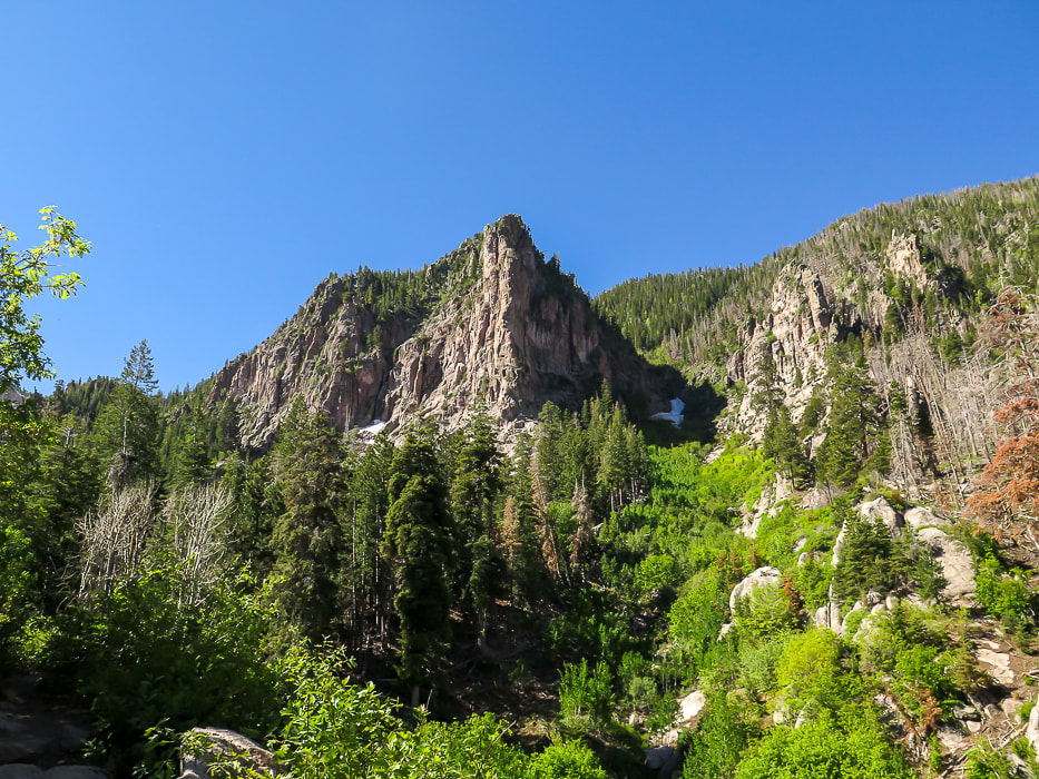 Large crag on right side of Forsyth Trail.
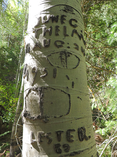
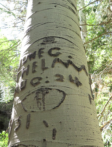
This forest is filled with large, towering aspens. Many had names and dates carved into their trunks. The carving above has a date of August 24, 1951. The depiction of a mountain range with a moon overhead made this one unique. This is possibly a Basque sheep herder carving or "arborglyph". Basque sheep herders had a lot of time to pass and many carved not only their names, but also simple scenes of life in the mountains. We returned to summit Signal Peak in 2022 in autumn - the colors were spectacular. 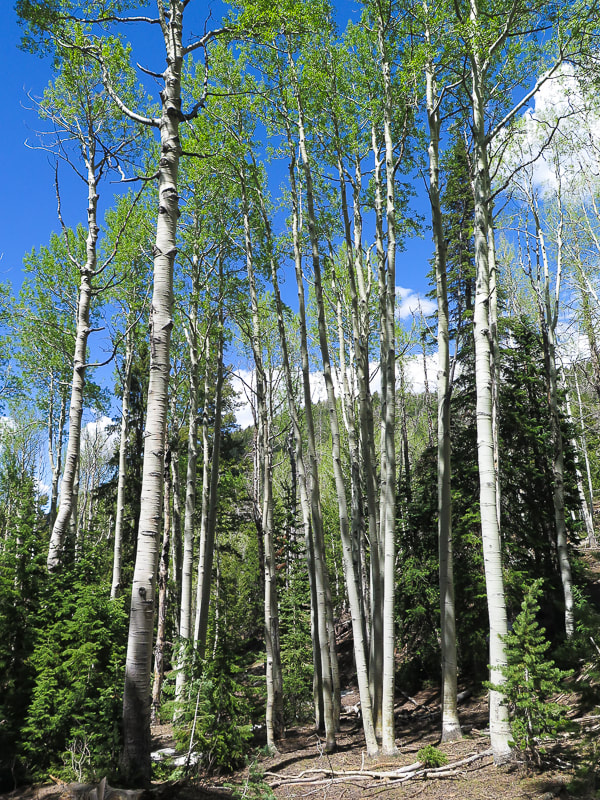 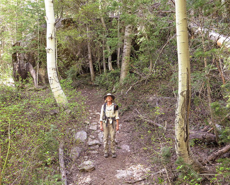 Sue on the trail! 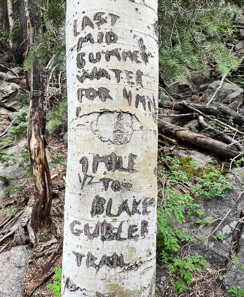 At final Forsyth Creek crossing, this inscription reads: "Last mid-summer water for 4 miles. 1 mile to Blake-Gubler Trail."  Mid-way up Forsyth Canyon - it squeezes in between steep crags on both sides.  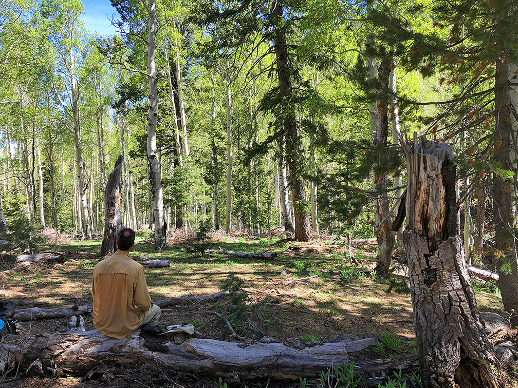 Lunch break at small meadow - 4.2 miles in on Forsyth Trail
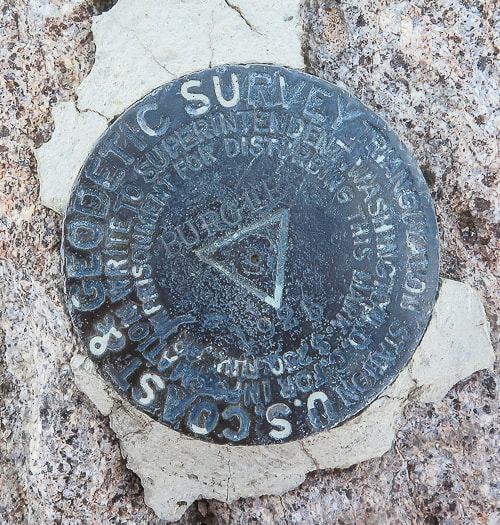
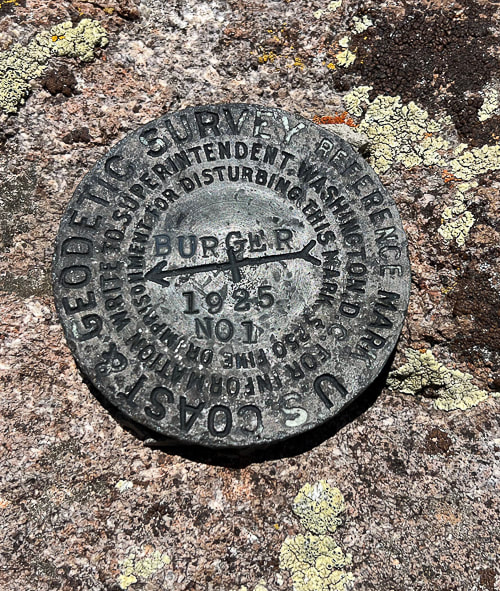
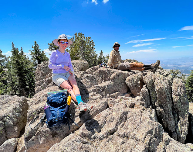
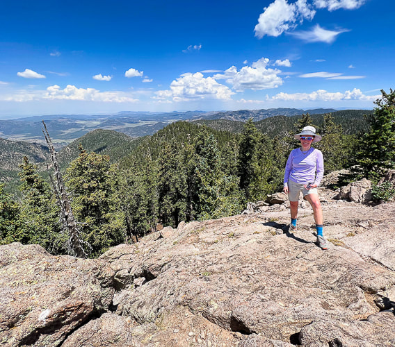
 Spur trail to Burger Peak Summit The spur trail to Burger Peak summit leaves Summit trail just as it is descending toward Signal Peak. It is easy to spot on the left once you walk past killer views of Snow Valley, Red Mountain, and Zion National Park. It starts as a path and then you can spot sporadic cairns to lead you northeast over ridge crags to the actual summit, ~ 0.3 miles from Summit Trail. Ponderosa Pines, firs, and steep crags dominate Burger's summit. The summit has a register and a geodetic triangulation survey marker and a great view of the town of Pine Valley to the north. 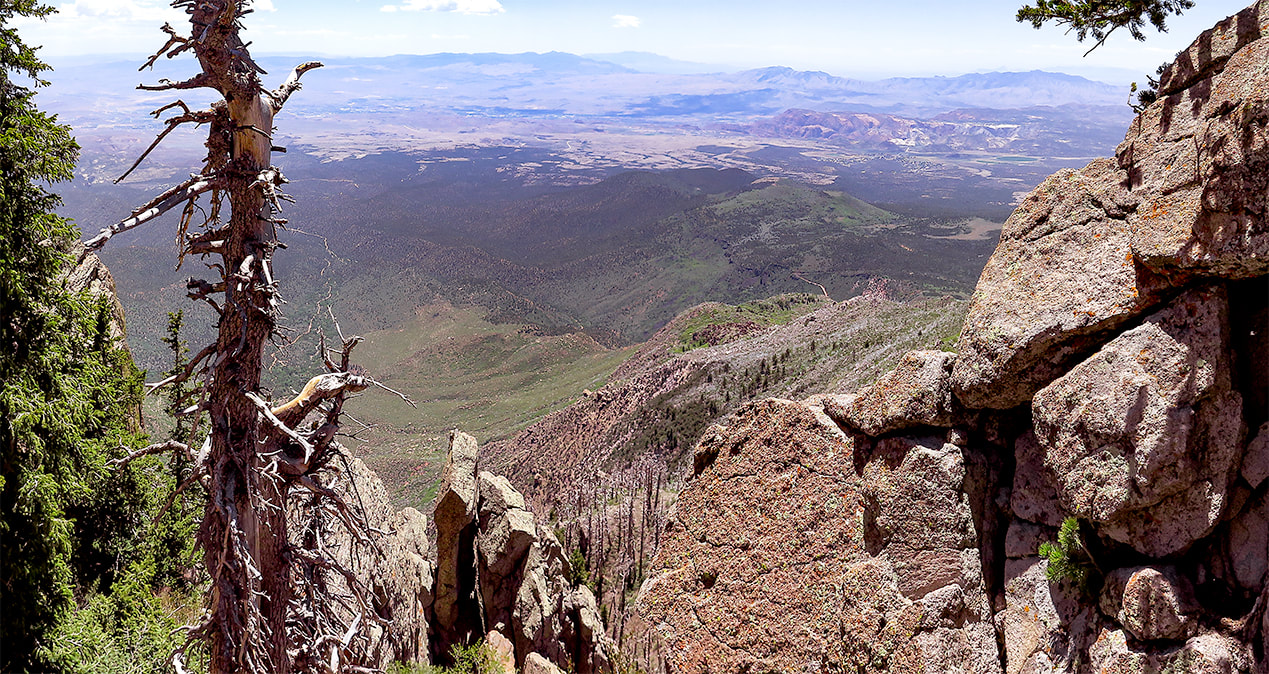 Finally get an opening in the forest ~ 5.7 miles into the hike to view vast Southern Utah: St. George, Zion National Park 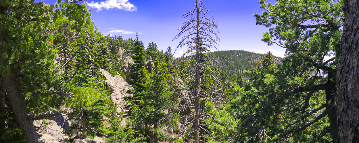 View of Signal Peak, highest point in Pine Valley Mountains from near Burger Peak's summit 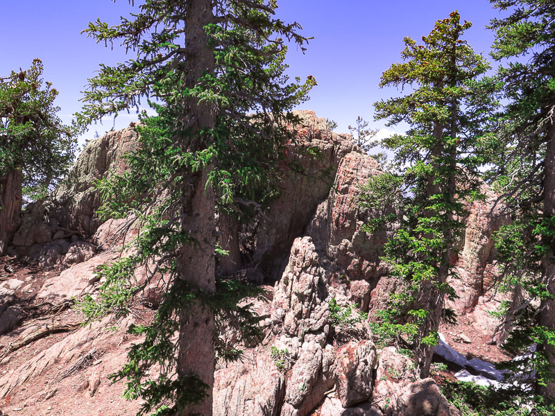 Rock walls to walk between and around at Burger Peak's summit. Keep heading northeast to the highest crag, the highest point on Burger Peak with register and triangulation survey marker. 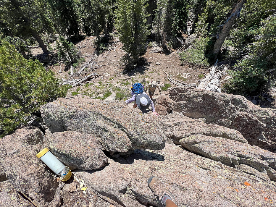 Laura and Fred climbing Burger Peak's summit with register on top. From Burger Peak's summit 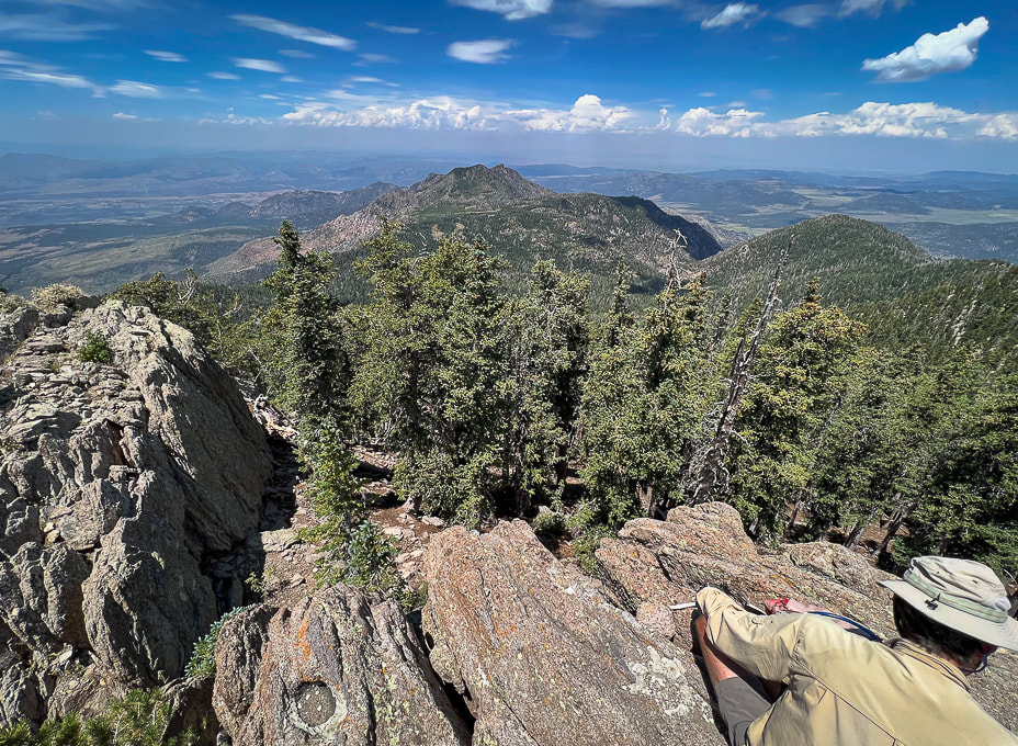 Looking west from Burger Peak summit. 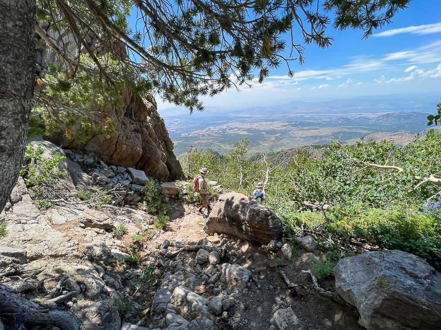 Heading back down with view of Red Cliffs Desert Reserve to the south. Pine Valley has an interesting history. It was discovered by Mormon pioneers Gunlock Bill Hamblin, Jacob Hamblin, and Isaac Riddle when they were moving cattle north of Santa Clara for summer grazing. A sawmill to process lumber was erected in 1856. The tall white Pine Valley Chapel stands out as you drive through town. Built in 1868 according to Ebenezer Bryce's plan, it is the oldest meetinghouse in continuous use of the Church of Jesus Christ of Latter Day Saints. Bryce reportedly followed a lost cow later into a beautiful canyon - the now famous Bryce Canyon National Park. He had huge granite boulders placed at the corners of the foundation. Bryce's experience in Scotland as a shipbuilder was the impetus for the well-constructed chapel. Regrettably, The Pine Valley Heritage Center in town was closed as we finished the hike. We will be back to explore more of this exquisite wilderness. Possibly some snowshoeing in the winter? For now, we head back to the sweltering St. George heat and its red sandstone to look up to the granite crags and cool Pine Valley Mountains.  Break at the intersection sign - done with most of the large snow drifts!   Descending rugged Forsyth Canyon  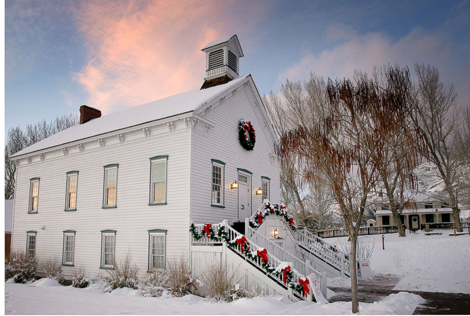 Pine Valley Chapel Downloaded from internet: https://www.thisistheplace.org/pine-valley-chapel-rental 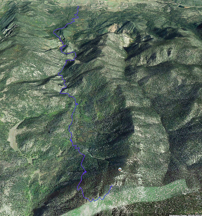 Google Earth image of our tracks from Pine Valley (north, or top of image) Utah to (almost) Burger Peak summit via Summit Trail. Deep snow prevented us from getting to true summit. References
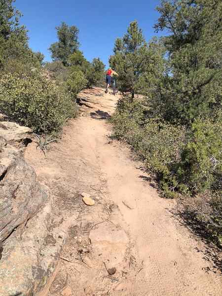
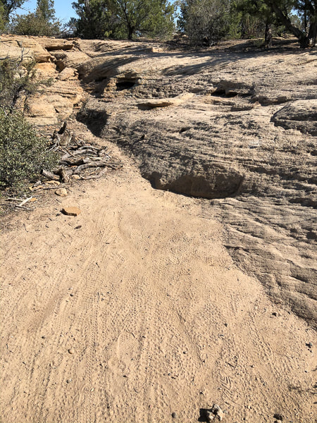
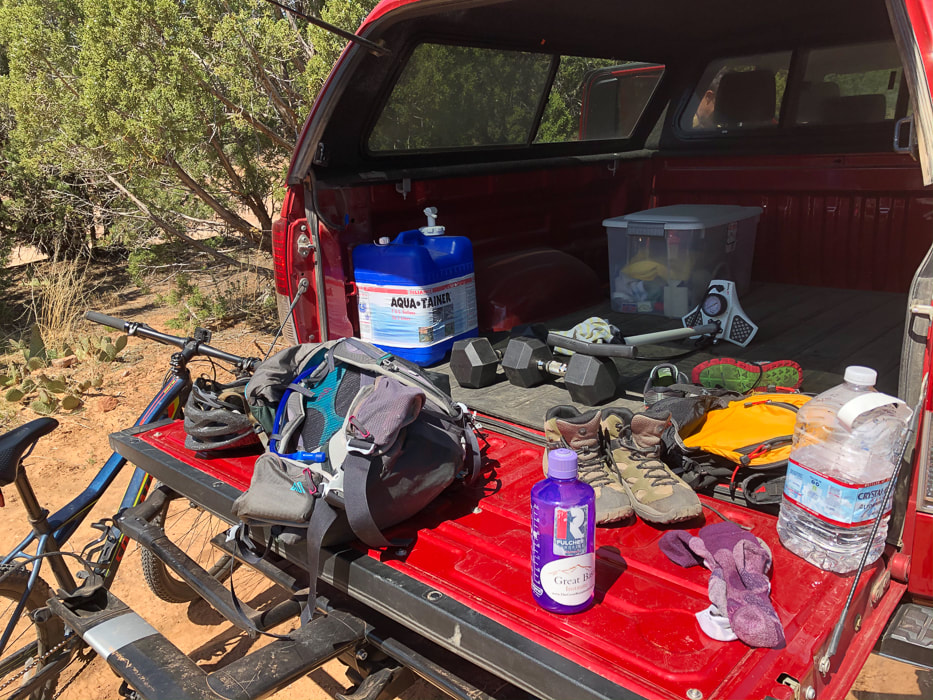
Pine Valley Mounains - Wikipedia Exploring Burger Peak via Forsyth Canyon. Don Gilman, September 26, 2018. Southern Utah Now. Pine Valley Utah Official Home Page - History. pinevalleyutah.org Pine Valley: More than a Chapel - Church History. history.churchofjesuschrist.org Pine Valley Chapel brochure from the Church of Jesus Christ of Latter-Day Saints Southern Utah Hiking and Biking in a Pandemic: Wire Mesa, Snow Canyon and Zion National Park4/20/2020 While many stayed home during COVID-19 isolation orders, we ventured to Southern Utah for an unplanned visit to quiet Zion National Park, a spectacular Wire Mesa mountain bike ride, and Snow Canyon State Park. Related: Angel's Landing in Zion: Not for the Faint of Heart Canaan Mountain via Squirrel Canyon Zion National Park - Double Arch Alcove Hike Utah Mountain Biking - The Cowbell and the Cryptobionic "Highway" Desert Plants  Snow Canyon State Park near St. George, Utah Snow Canyon State Park - April 1, 2020 The spring of 2020 will always be remembered as the time of the Coronavirus pandemic. After Fred and I did more research than usual, we managed to get away on our annual Southern Utah trip despite Idaho's order to self-isolate. It states, “The isolation order does not prohibit outdoor activity such as walking, hiking, running or biking, but a safe distance of six feet must be kept between those who do not live in the same household.” Utah’s orders were similar. We are very experienced in the art of social distancing - it comes naturally. This time, however, as we planned our getaway from Boise to sunnier climes, there was a lot more to consider: where could we stay? Could we bring our trailer? Are the Utah state parks and Zion National Park closed? Can we go on trails? Can we go at all? Visions of red and orange rocks, azure skies and red-blooming cacti outweighed the risks, so off we were, with assurances from the manager at the Marriott Hotel in St. George that we wouldn’t be sent home after the 9-hour drive. We had to leave our tent trailer behind as all parks and campgrounds were closed. Into the truck went hiking boots, bike helmets, backpacks, clothes for a few weather conditions, food and clean bikes. The promise of gear-grinding, rock-hopping, open-air adventures and the freedom to explore awaited us. Just a few more rules this time. The chilly morning lent crystal crispness to a clear sky; on our bikes, we faced the yellow and rust-red sandstone towers standing like sentinels along the gravel road in Snow Canyon State Park. The occasional CLINK of small rocks hitting my bike, the crunch of gravel under tires and the pleasant “good morning” greetings of couples walking along the road were the only sounds. Breathe deeply that clean desert air. We stash our bikes at the end of the road and walk a small distance up a narrow white ledge-lined canyon, following a sand wash with smoothed boulders. In the shade of a towering wall the temperature cools suddenly. I catch that unmistakable scent that only desert washes can produce – a sweet mixture of mesquite, yucca and sage, and the earthy scent of damp sand underneath. Snow Canyon State Park is a beautiful place to bike, walk and hike. We like to ride West Canyon Road and then find a high sandstone lookout and scramble up the slickrock for our lunch. This canyon was used by Anasazi and Paiute Indians; more recently, its beautiful ancient sand dunes were featured in Hollywood movies such as Jeremiah Johnson and Butch Cassidy and the Sundance Kid. While looking for lost cattle, Mormon pioneers discovered what is now Snow Canyon in the 1850's. Be sure to check out the black basalt that fills some of these canyons, creating a topographic high due to huge volumes of magma in what were formerly streams. Current restrictions as of 4/17/20: Governor of Utah's directive entitled "Stay Safe, Stay Home" which prohibits anyone from going to Snow Canyon State Park that does not live in the county in which it resides (Washington County). All users are to be ready to verify residency. Map of Snow Canyon State Park The Geology of Snow Canyon State Park  Snow Canyon State Park, Utah  Bridge Mountain on east rim of Zion Canyon Zion National Park, April 3, 2020 “Sulking indoors for the duration of this crisis is an obnoxious thought”, said Paul Theroux, Wall Street Journal travel writer. In his article addressing the stay-at-home directives, “A Wanderer’s Guide to Staying Home”, he mentions past famous people who wrote from home or nearby, like Emily Dickinson and Henry David Thoreau. He says, “to self-isolate means confinement; for habitual travelers it is something like punishment”; then he concludes that the “ultimate freedom in travel lies in the road trip – setting off in your own car.” My bare hands stung in the freezing wind blowing through Zion Canyon’s morning half-light as the hulking sandstone giants lining the eastern side shut out the sunlight to the canyon bottom. Fumbling with my camera and tripod, I spent no time looking for gloves, as the light on Bridge Mountain, a massive, cross-bedded ancient sand dune was changing fast. The visitor's center was abandoned, all parking places empty. Part of me felt jubilant that I should have Zion all to myself, to photograph without constraint; the other part felt a slight uneasiness at the absence of people in this place that is visited by four million people each year. The sun now sat on top of Bridge Mountain's ridge; it was time to move on. We weren't surprised when we saw the sign "Angel's Landing Is Closed." It is probably the most famous hike in Zion, and for good reason; to get to a breathtaking view of Zion Canyon, you hold onto bolted chains much of the way while climbing up a narrow fin of sandstone, walls dropping straight down for hundreds of feet on either side. The sign read, "Violation of this closure may result in a fine of up to $5,000, 6 months in jail, or both." I have seen a line of people waiting to ascend but today it was eerily vacant. We continued past this and walked the West Rim Trail to where plants grow on sandstone walls overlooking Telephone Canyon. When we went to the only open shop we could find to get ice cream afterwards, the employee there told us that Zion National Park was closed just one-half hour ago. We'll always remember this lucky day when under sunny skies and perfect weather, we were able to hike Zion on nearly empty trails. Too bad we couldn't do Angels Landing! Zion National Park info and map 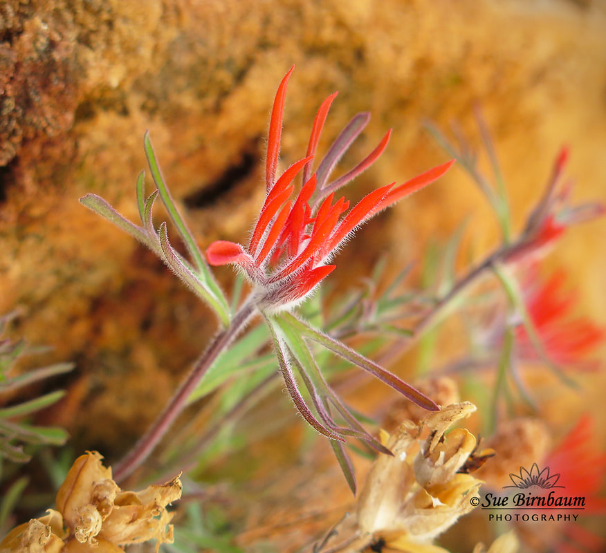 Indian Paintbrush in Navajo Sandstone Castilleja scabrida 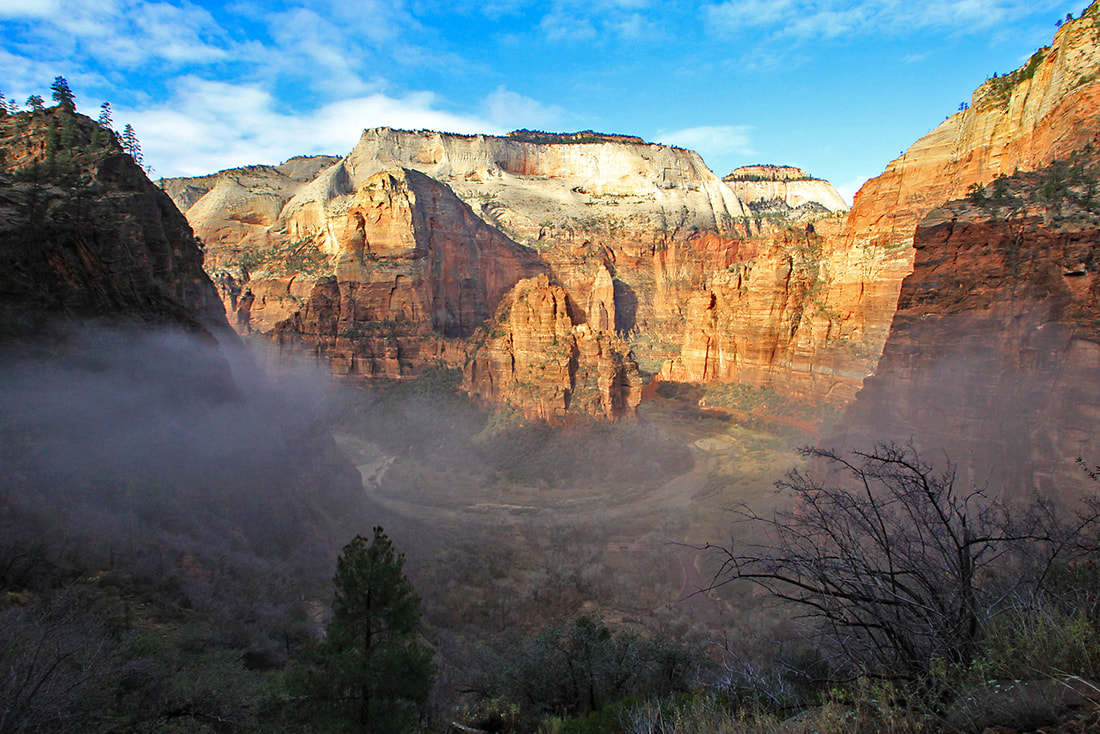 From East Rim Trail looking at the Virgin River, Angels Landing and Cathedral Mountain - Zion National Park  From the Kayenta Trail looking up toward Castle Dome and Mount Majestic - Zion National Park 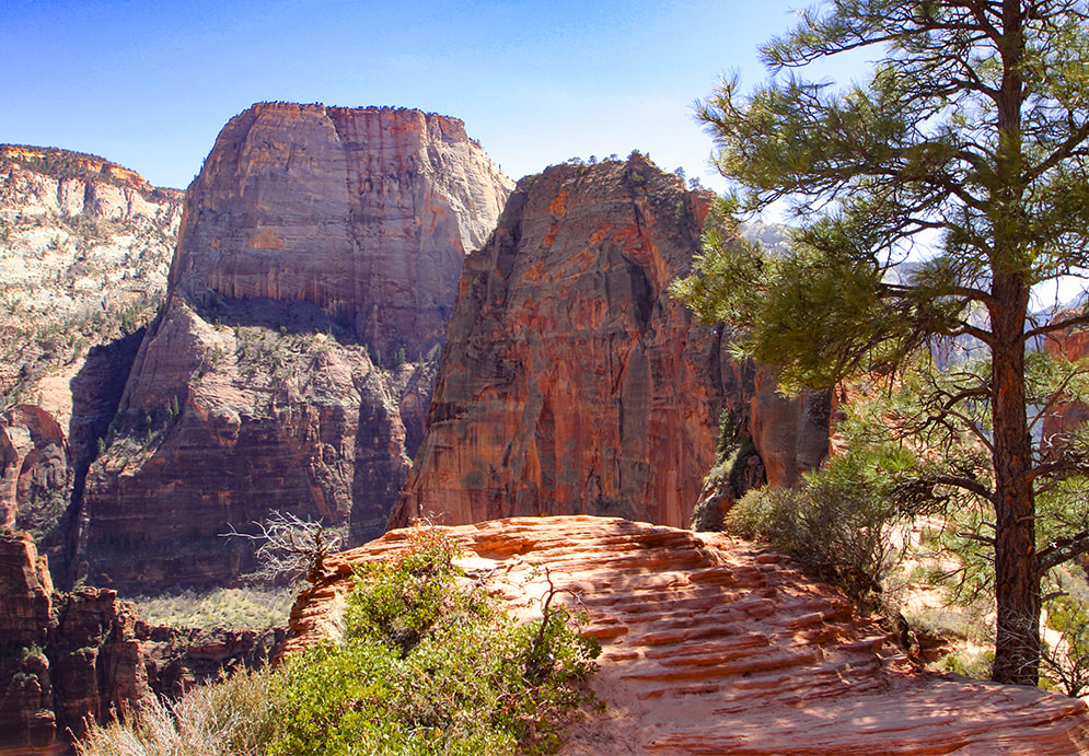 Angels Landing on the right; Great White Throne on the left - Zion National Park 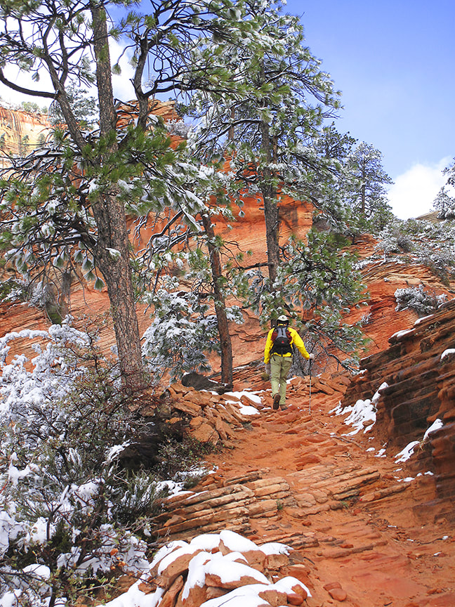 West Rim Trail - Zion - 10 years ago after a March snowstorm  Emerald Pools Trail - Zion   View of Mount Kinesava from Eagle Crags Trail south of Zion National Park Wire Mesa Mountain Bike Ride, April 4, 2020 The Wire Mesa loop is a 7.6-mile rock-navigating, killer view single track source of joy. We rode counter clockwise, having prominent Mount Kinesava with its vertical cliffs and other Zion Canyon temples in view until we reached the end of the mesa and the trail contoured to the west. Most of this trail winds in and out of junipers, up and down over forgiving sandstone rocks, close to the mesa's edge. We were surprised at the number of groups of hikers, campers, and bikers practicing their own wilderness social distancing. The steep road up to the mesa from Rockville is best attempted with a 4WD vehicle. Deep tire ruts attested to those who had traveled this clay-soil road probably the week before when there were downpours. Utah mountain bikers are technically skilled, focused on mapping a route up and over sandstone. We got better at this skill as we rode, but we did end up walking our bikes over many "steep" rocks. After this ride, we hiked in the Canaan Mountain Wilderness administered by the Bureau of Land Management, near Wire Mesa. We encountered many cheerful hiking families and couples. The BLM's current Coronavirus Advisory states "Please follow recommendations from the CDC and your state and local health authorities before visiting your public lands..." It will be interesting to find out what directives and orders we must follow for our hiking and back packing trips this summer while we do what we love to do - "natural" social distancing. Meanwhile, the red sand on our bike chains attests to the great adventures we had in Southern Utah. MTB Project - REI - Wire Mesa Loop Information 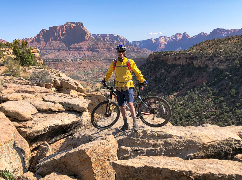 Wire Mesa Trail - Mount Kinesava on left, along with temples and mountains in Zion Canyon 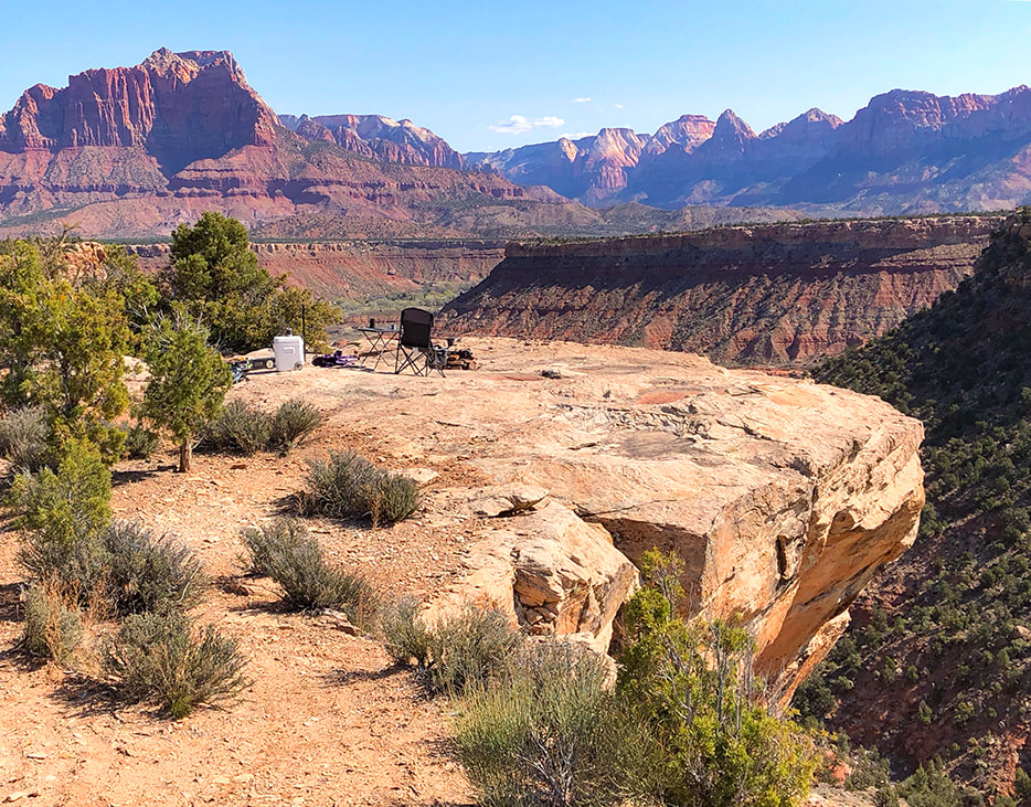 A great camp spot on Wire Mesa Trail. Mount Kinesava on left
 The art of "social distancing"  Ahhh, that beautiful red clay/sand soil of Southern Utah! 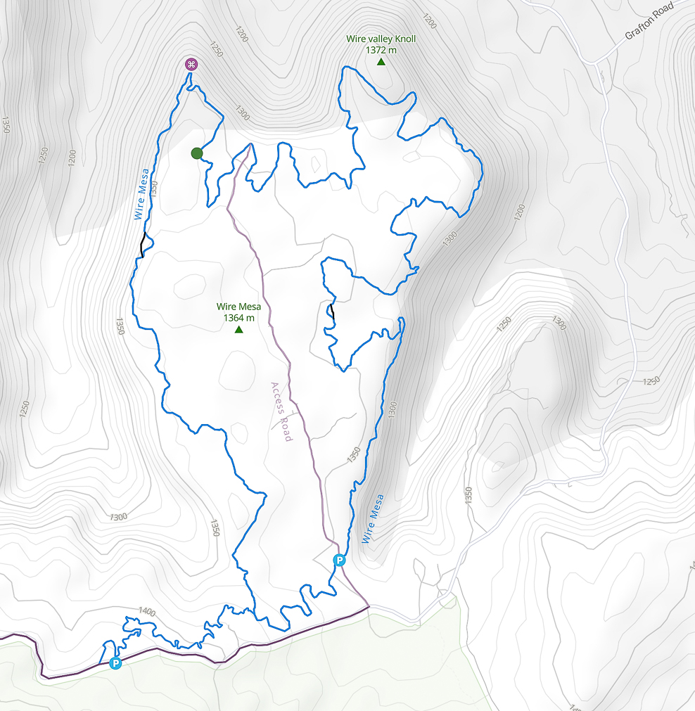 Map of Wire Mesa Trail south of Zion National Park, north of Canaan Mountain Wilderness
Click for larger image Canaan Mountain, a towering plateau of Navajo Sandstone is a classic southern Utah adventure through red sand, forested canyons and over ancient sand dune slickrock. Located south of Zion National Park, it is wild and beautiful. Related: Mt. Kinesava - Zion National Park Double Arch Alcove Hike - Zion National Park Angels Landing In Zion - Not for the Faint of Heart White Domes via Water Canyon - Canaan Mountain Wilderness Southern Utah Hikes 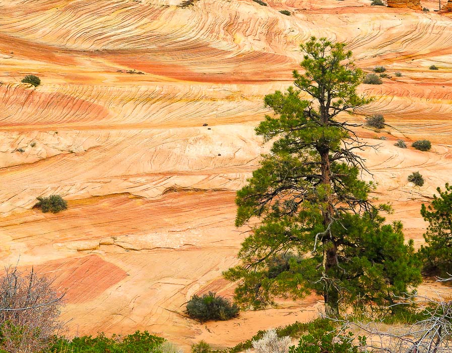 Ponderosa Pine and petrified sand dune on plateau below Canaan Mountain Trip Stats Overview: Experience a variety of colors and terrain on a hike that treks up a steep canyon to Navajo Sandstone pinnacles, domes, and hoo-doos. Walk through a broad canyon bottom with a stream and towering cottonwood trees, then up a beautifully forested canyon with waterfalls and hanging gardens. The trail then tops off onto a plateau with spectacular sandstone features and deep canyons; further climbing on open slickrock gets you to the summit of Canaan Mountain. Located several miles south of Zion National Park, Canaan Mountain Wilderness is on BLM land. Spectacular and wild without the crowds. Elevation gain: Canaan Mountain is a towering plateau measuring 8 miles by 10 miles; the highest point = 7,363 feet. We hiked to 6,863 feet. Trailhead elevation = 5,120 feet. Our elevation gain = 1,740 feet. Elevation gain to highest point on summit from Squirrel Creek Trailhead = 2, 242 feet. Distance: variable depending on which part of summit you access. Our round -trip distance = 12.5 miles. To go to Sawmill Spring at higher elevation, add ~ 3 miles one way. Location: highest point on summit: 37.0739° N / 113.0375°W Difficulty: Moderate; Squirrel Canyon steep toward top, requiring some light hand-support, route finding on Sawmill Trail is necessary as there are few cairn markers. Maps: USGS 7.5 min topo - Hildale, Utah-Arizona, Trail Map and Guide for St. George, Hurricane, and Zion NP, Utah by www.AdventureMaps.net, Topozone map. Links: BLM Canaan Mountain Wilderness, Cedar and Sand blogspot. Caution: Trail mostly in wilderness; there are no signs; be prepared with topo map and hike directions. Cairns mark route up Squirrel Canyon and then at intersection with Sawmill Trail. "It is not enough to fight for the land; it is even more important to enjoy it. While you can. While it’s still here. So get out there and hunt and fish and mess around with your friends, ramble out yonder and explore the forests, climb the mountains, bag the peaks, run the rivers, breathe deep of that yet sweet and lucid air, sit quietly for a while and contemplate the precious stillness, the lovely, mysterious, and awesome space." - Edward Abbey Driving Directions (from Hurricane, Utah) Traveling east/southeast on Utah Highway 59, turn left (east) onto Utah Avenue (right before Subway restaurant in 2018) in Hildale. Continue on pavement for ~ 2 miles, then Utah Avenue curves left (north) and becomes Canyon Street. At 2.5 miles from highway 59, turn right onto Water Canyon Road (road becomes dirt). Travel ~ 1 mile to a sign on the right of the road that reads "Squirrel Canyon Trailhead". Trailhead parking is just ahead.
Hike Directions
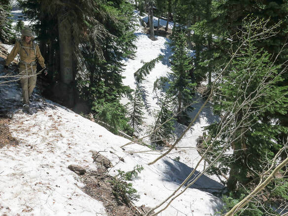
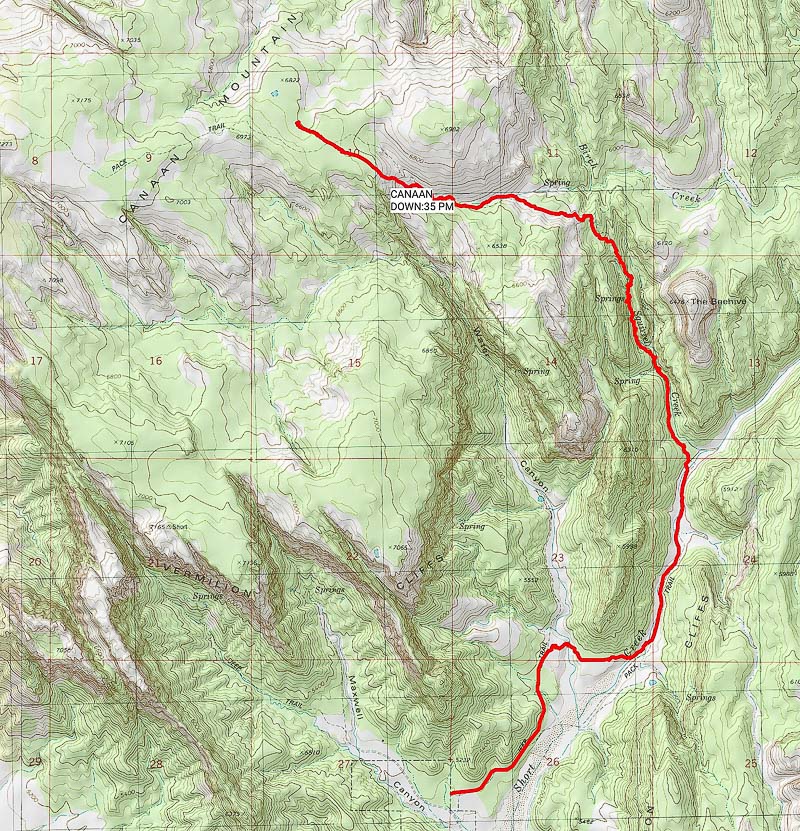 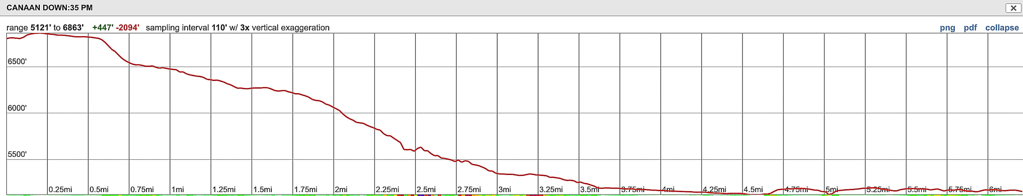 Our route up Squirrel Canyon to lower elevation of Canaan Mountain We ascended to 6,900 feet; the summit is 7,363 feet (note: profile illustrates trail starting at our highest point and descending back to trailhead) 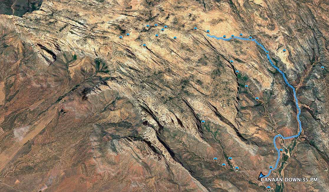 Our route up Short Canyon to Squirrel Canyon to summit of Canaan Mountain at 6,900 feet. The highest elevation of the summit is to the left (west) at 7,363 feet Beginning of trail at Squirrel Canyon Trailhead in foreground, red arrow points to trail that bears right around red bluff on left to go down into Short Creek in ~ 0.5 miles Our Hike We became "temporarily bewildered" when we didn't see the continuation of the trail just after the descent into the first wash (see photo above), so we lost some time with a little backtracking. This costs precious time, especially when days are short and the hike to the summit is long. We re-oriented and found the trail continued out of the wash and around the red bluff to the left, on its way to Short Canyon. There are no signs or trail markers until the climb up Squirrel Canyon, as this a wilderness area (an advantage: not many people on the trail!) We would still make Canaan Mountain, but not the highest point on its summit which is a longer hike. We stayed in Hurricane, Utah for Thanksgiving weekend in an old Zion NP ranger's cabin. Hiking in and near Zion National Park is a great way to celebrate the holidays. I have been hiking in Zion since the early 1990's. We avoided crowds this time by choosing hikes outside of the park. I was very impressed by the Canaan Mountain Wilderness because of its rugged beauty and all of the sandstone features throughout, and the fact that we basically had the place to ourselves. My kind of holiday! 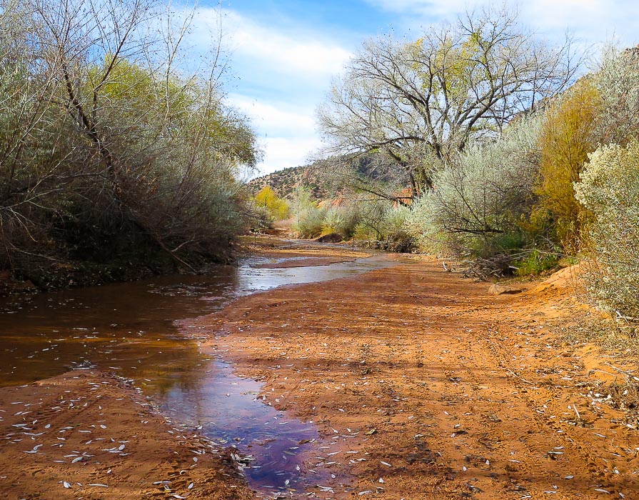 Entrance into Short Creek Entrance to Squirrel Canyon one mile upstream from this - hike along ATV road on right side of creek The hike starts by descending through deep orange sand, across a wash, and continues on the orange sand straight ahead. It rounds the red bluff to the left and then drops into Short Creek, ~ 0.5 miles from trailhead. There were a few people riding ATVs on the trails and washes; they looked like they were having fun. The steep canyon walls shaded Short Creek and its huge Cottonwood trees in the morning. This scene looked much different in the afternoon on the way back to the trailhead with the yellow leaves brightly glowing in the direct sunlight streaming through the canyon. The brief walk up the creek before the trail scrambles up a small bank under a huge grove of Cottonwoods is beautiful. Sand ripples alternating red and black lie under shallow water reflecting the sky. The trail then follows a 4 WD road along the creek, passing by plenty of grey rabbitbrush shrubs whose flower heads glow a cream color in the sun. Patches of white sand are deposited on the bank above the stream, possibly sediment from the white Navajo Sandstone layer further upstream. The entrance into Squirrel Canyon, about one mile upstream is obvious, as the ATV/hiking trail crosses Short Creek. A wide and relatively flat area at the entrance was covered with autumn leaves. The trail ascends Squirrel via the 4WD road and then a single track trail as the canyon narrows. Oak and maple trees surround and form an autumn canopy of red, brown and green, while green moss and maidenhair ferns dripped water seeping from vertical sandstone walls. The trail transitions from the soft tread of seasons of leaves to hard and angular slabs of sandstone to soft white sand as it emerges from the canyon then tops out on a beautiful plateau underneath The Beehive, an ancient sand dune. In a short distance from emerging, the canyon trail intersects with the Sawmill Trail with a pile of rocks marking this point. As we turned left at this point (west), I glanced back to make sure I wouldn't miss this intersection on the way down.  A somewhat ominous entrance into Squirrel Canyon  The Beehive, elevation 6,476 feet Seen as Squirrel Canyon Trail opens up onto plateau above canyon website for climbing The Beehive  Cairns mark route over sandstone while going up Squirrel Canyon An excellent feature of this hike is that it gains enough elevation to walk through at least two geologic formations. The top of Canaan Mountain consists of the massive Navajo Sandstone which is also observed in the towering walls of Zion National Park. The hike appears to be starting in the red cliffs of the Kayenta Formation (mudstone) that lies below the Navajo Sandstone. The transition I noticed was in leaving the red sands and cliffs behind in Squirrel Canyon and ending up on the white rocks and white sand on the plateau above. The upper walls of Canaan Mountain are the White Cliffs of Navajo Sandstone, and at the base are the Vermilion Cliffs which can be seen at the trailhead. These cliffs are widespread throughout southern Utah and Northern Arizona. At this location, they face southeast, and in the morning sun the walls are ablaze with intense orange, yellow and red (read more about geology of this area below). The plateau above the canyon is a wondrous world of layered, cross-bedded, curving cream-colored and orange sandstone, with never-ending examples of eroded Navajo Sandstone features. Huge junipers make you wonder how old they are. Dark and light-striped hoo-doos, domes and platforms in all shapes and sizes are so plentiful - I wished that I was camping up there so I could spend more time looking. Ponderosa pine and juniper contrast against the frozen-in-time deeply angled and curving sand dune cross-beds. The spectacular dark and forested V-shape of the entrance into Water Canyon looms to the south. Time was getting short. We left Sawmill Trail and scrambled up ledges of slickrock to the highest point on the summit north of us, which is not the highest on Canaan Mountain. We found ourselves in yet another world of a flat-topped forested plateau with soft white sand. Only a few hours of daylight left - we had to get back. Sawmill Trail required close attention because it was marked by cairns sparsely at best, requiring us to "hunt" for the trail sometimes. The trail alternated between soft sand and slickrock, steep in parts. Tire tread from a recent jeep was helpful to navigate the way. With each turn, rise and descent, there is almost an overload of beautiful, stark, weird, unusual sights along with the feeling of elevated space and expanse in every direction. 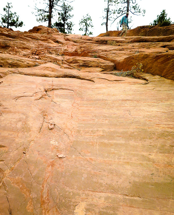 At this point on Sawmill Trail, the only marker for the trail was these scrapes in the slickrock. It rose steeply over the rocks on this rise  Sawmill Trail weaves in and out of soft sand and cross-bedded Navajo Sandstone  Sand of Sawmill Trail lower left hand corner. We hiked to the right, up to the top 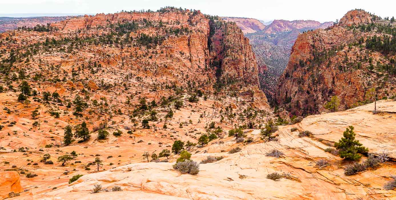 At 6,500 feet with view of the Notch toward the south  Leaves found on Squirrel Canyon floor Common trees of southern Utah canyons are Canyon Maple, Boxelder, Fremont Cottonwood, Scrub Oak, and Gambel Oak. Ponderosa Pine, Pinyon Pine, Gambel Oak, Manzanita, and Douglas Fir grow on slickrock.  Heading down Squirrel Canyon Beautiful canyon with bright green moss, clear pools and waterfalls, thick canopy of oak and maple trees We saw no one else in the canyon and on the slickrock plateau. It was easy to get sidetracked in Squirrel Canyon while getting almost hypnotized by watching oak leaves floating in clear pools that had ripples on the bottom. As we made our way back to the trailhead, on the ATV trail that runs along Short Creek, a large group of young backpackers were plodding towards us in the deep red sand, laughing and smiling, silhouetted by the late afternoon sun. Huge Cottonwoods, strong and rooted along the white-sand bank with leaves glowing yellow lined our way back down Short Creek. These had massive trunks - the vegetation in this area is so robust and healthy. I'm going back - I can see why the party of backpackers looked so joyous! Next time - Water Canyon! Geology and History The age of rocks on Canaan Mountain are Lower Jurassic (201 - 174 Ma). It is capped by 1,300-foot cliffs of Navajo Sandstone. The Kayenta Formation underlies the Navajo. The Kayenta is then underlain by the Moenave Formation. The base of the White Cliffs of Canaan Mountain is part of the greater extent of the Vermilion Cliffs, which extend over a large area of Utah and Arizona.
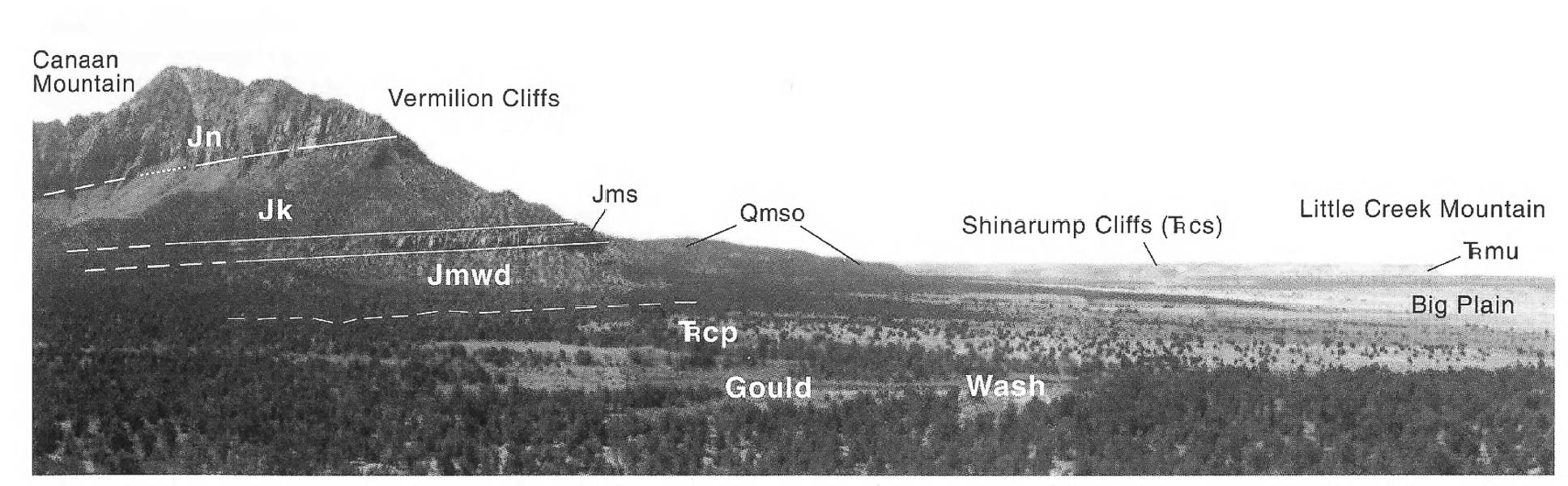 Key to stratigraphic units in above photo: Eroded Navajo Sandstone on cap of Canaan Mountain 1,200 feet thick; Canaan Mountain is ~ 2,000 feet higher than the plain (Jn). Kayenta Formation (Jk), Moenave Formation consisting of the Springdale Sandstone member (Jms), Whitmore Point and Dinosaur Canyon members (Jmwd). (From Geologic Map of the Smithsonian Butte Quadrangle, cited below). References:
   Temps in the 20's at night at ~ 6,200 feet in late November  Sawmill Trail treks through sand and sandstone  Cairns mark first trail off of Sawmill Trail that treks to the lower reaches of Canaan Mountain summit   Pool in Squirrel Canyon  Along Short Creek
Hike the remote cross-country route of the last mule U.S. mail delivery in the Phipps Death Hollow Wilderness Study Area through slickrock sandstone and sagebrush flats 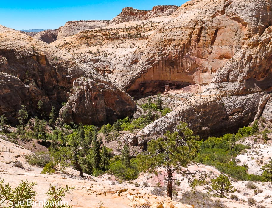 Descending into Death Hollow from northern route of Old Boulder Mail Trail Cross Country Route Trip Stats:
"If ever monuments are erected to unsung heroes, probably the tallest should be for those who brought the mail." - Nethella Woolsey, Escalante historian 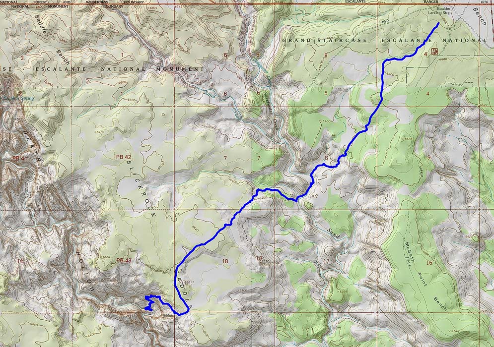 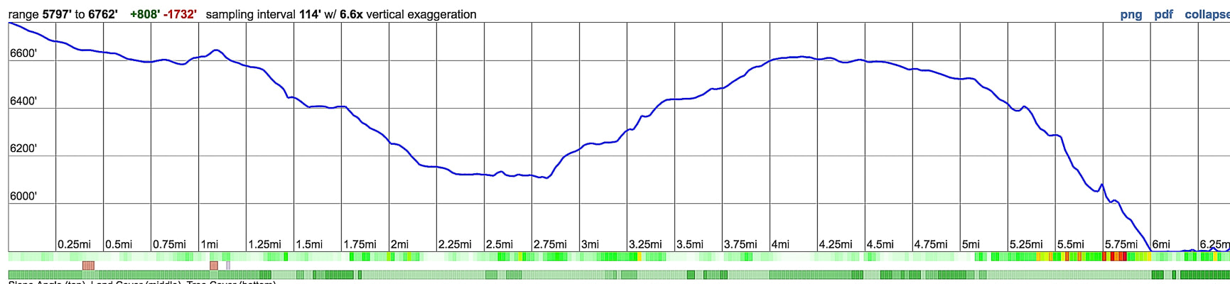 Northern section of Old Boulder Mail Trail Cross Country Route travels southwest from trailhead near Boulder Landing Strip to Death Hollow. This trail descends to Sand Creek, climbs to Slickrock Saddle, then descends again to Death Hollow. Our Adventure It was the vivid colors in Death Hollow that I remember most when Fred and I hiked the Boulder Mail Trail 18 years ago. Bright blue skies, red rounded rocks, orange and yellow cut walls, verdant willows: the whole scene reminded me of the hues on the art class color wheel. We saw only two other people on the trail that day - two guys swimming and splashing joyfully under steep walls. So extraordinarily different this hollow was from other streams I had hiked before whose colors, albeit beautiful, are usually various shades of brown, grey and green. Here, in the middle of an immense sandstone sea, we had color combinations only the desert can produce. On a very warm day in June this year, Fred and I hiked this trail again. The sandstone wall of Death Hollow as the Boulder Mail Trail enters it from the north is bright yellow and grey. I wondered if that rock surface could really be that colorful, and checked the colors of vegetation in the images I was taking. Maybe it was a reflection of the sun? Sandstones can be yellow due to dissolving of calcium carbonate, a common cementing material. The grey vertical stripes looked like weathering stains to me. 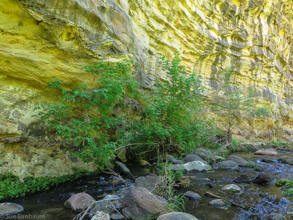 Death Hollow where Boulder Mail Trail enters from the north These days, the Boulder Mail Trail trailhead is generously marked. The first 1.5 miles trek steadily down a bench through a pinyon/juniper/sagebrush forest. Views suddenly open up as the trail drops down into sandstone hills and gulches of the Sand Creek tributaries. Rock cairns mark the trail for the remaining trek to Death Hollow (and then on to Escalante), except for a few sandy stretches where the trail is marked initially by a cairn. 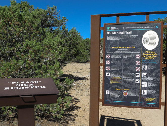 Boulder Mail Trail trailhead sign and register 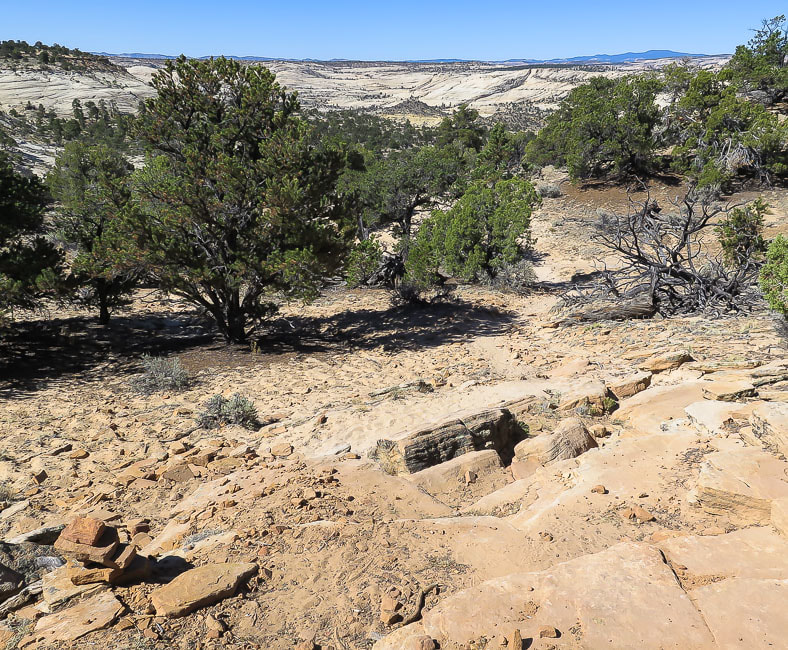 Nearing transition from plateau to shallow Navajo Sandstone canyon. Look at that marvelous open country in the distance that we get to walk through! 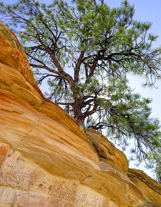 The trail zig-zags through a sandy opening of a shelf of eroded orange sandstone layers and deposits you onto the immense slickrock. As you leave the plateau behind, two and even three cairns can be seen ahead, linking the trail to Sand Creek. So much to see in such a stark landscape: grey lichen, aged wood, sand pockets, and water-smoothed channels. 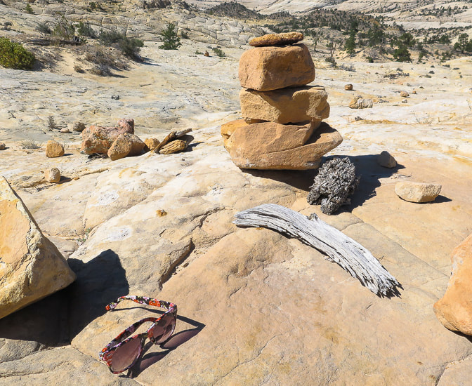 You never know what you may find on slickrock
At 2.7 miles, cross Sand Creek, flowing in mid-June. Walk on right (west) side of creek through willows for ~ 0.2 - 0.3 miles to cairns that climb out of creek bottom and briefly switchback over a knob. We had to backtrack here because we followed the creek too closely to the shore. The climb from Sand Creek to the highest point on Slickrock Saddle is ~ 500 feet. The initial climb out of the creek is steep, then alternates between less steep and steep rises (see profile chart, above), trekking around the northwest side of a large dome with hoodoos on top. Telephone wire installed 108 years ago runs along the trail as it treks through long stretches of deep sand in a pinyon/juniper forest. This segment leads to the summit of Slickrock Saddle Bench at 6,600 feet and the first view of Death Hollow.  Telephone line installed in 1910 runs along trail - insulators attached to trees like this one above in a dead Ponderosa Pine 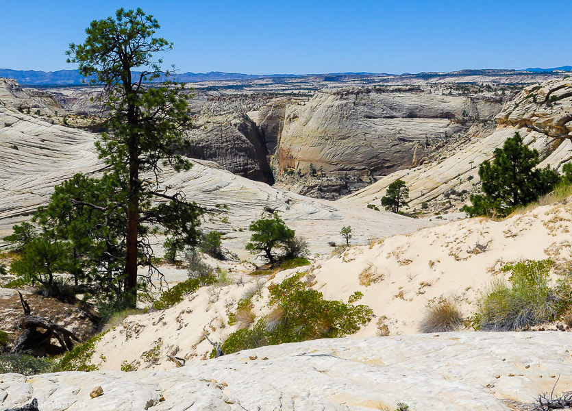 First view of Death Hollow from top of Slickrock Saddle Bench - last bit of sand hiking in foreground As you make your way off Slickrock Saddle Bench, the shadowy chasm of Death Hollow becomes deeper and deeper; you know it's there, but it just won't reveal itself right away. It's tempting to stare in awe at this unique sight, but stay focused on the cairns, too, because the trail swings south and skirts around a knob at 6,617 feet, heading for the best way off the bench. Next, the trail switchbacks and treks in a northwest direction. The steepest part lies ahead, and you wonder how mules delivering mail in the early 1900's walked across this precarious descent. A passage from the book "Advised them to Call the Place Escalante" reads: "To a reader sitting in a comfortable arm chair it is hard to describe the beauty of the Death Hollow Trail or the fear caused while sitting astride a horse trying to make its way safely over the rough terrain. It is said that horses' legs literally quivered as they gingerly picked their way down the trail." - Jerry C. Roundy, Escalante resident and author of "Advised them to Call the Place Escalante" This trail was known in the early 1900's as the Death Hollow Trail, and it was the shortest route between Boulder and Escalante. It was the fastest route if one was in a hurry, for the wagon road between the towns was a longer distance. Parts of this trail were "blasted out" in order for safe horse passage. Tales of cream cans and eggs being delivered via the Death Hollow Trail among other trail experiences are described in Jerry Roundy's book. The residents of Boulder and Escalante finally received the mail service they had been petitioning for in 1902 when the first government mail carrier's contract was given to an Escalante resident, who would deliver mail using the Death Hollow Trail twice per week. I'm more aware of my balance on the steep slickrock; most of the texture of the rock enables my boots to grip well, but there are smoother patches to look out for. I imagine what it was like to lead horses and mules over this section. Did they slip? During the winter was there ice? What would this place look like with several inches of snow? Or under a full moon? I believe the Death Hollow Trail mail carriers were pretty tough, and they got to see some of the most beautiful scenery in the world. Starting at ~ 5.25 miles, the well-marked trail switchbacks and descends 600 feet in 3/4 of a mile to the thick vegetation of the flowing creek in Death Hollow. Some moss-covered rocks were slippery to step onto. There's a sweet tent spot at the terminus, and from the paths seen on the treeless part of the shore on the descent, there are probably more tent spaces available. This time we didn't hike down Death Hollow as we did 18 years ago, although the water would have cooled us off in the mid-80's temperature. Vegetation along water seemed thicker this time, but the colors and textures no less beautiful. The cool shade, chatter of water over rocks, sudden splash of colors and tall vertical walls in Death Hollow contrast with the bright and open, mostly shadeless trek across sandstone country. After resting in the shade, we started the 6-mile hike back, looking forward to the largest elevation gain of the trip - 1,450 feet. On the way back, we took a break at Sand Creek, near huge rounded basalt boulders, probably from Boulder Mountain, whose basalt age is 6 - 16 Ma, and whose run-off streams provide water for Sand Creek. There's always numerous adventures awaiting me, and seeing Fred walk across the slickrock is even more fulfilling than the hike, which is hard to beat. One of the best parts of life is the hope of future adventures in the beautiful American West. Next time - the entire Boulder Mail Trail! Two days earlier, Fred and I hiked from Escalante to Mamie Creek along the Boulder Mail Trail (the southern portion). Although we didn't get all the way to Death Hollow, I feel that portion of the trail is even more gorgeous. We had the Phipps Death Hollow Wilderness all to ourselves that day, as we saw no one else. It's days like these that I will remember reverently - forever. Below are some images of the portion of the Boulder Mail Trail Cross Country Route south of Death Hollow. 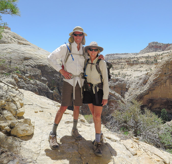 We ran into a retired biologist who took this photo of us after a detailed discussion of Fe+3, ferric iron in the rocks - very interesting to me, but Fred not so much! 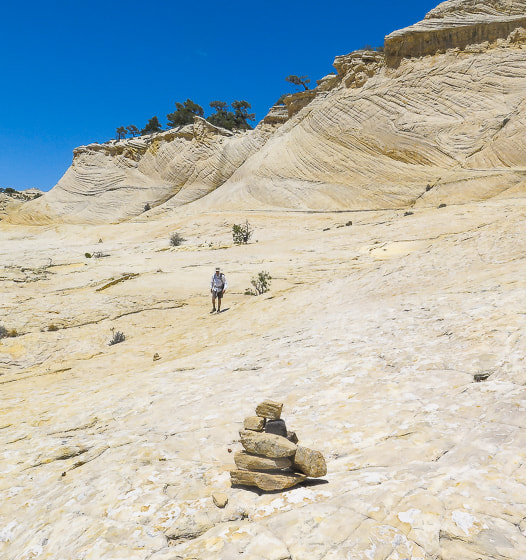 Thank goodness for cairns! Slickrock Saddle Bench  Basalt boulders near Sand Creek Images from south portion of Boulder Mail Trail Cross Country Route - Escalante to Mamie Creek 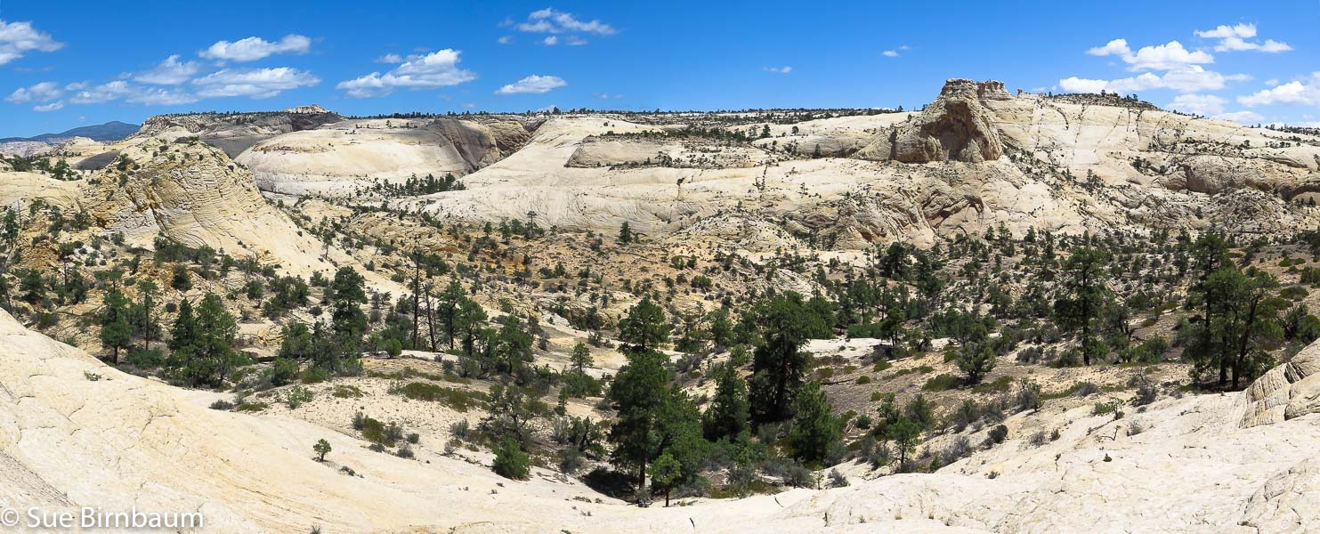 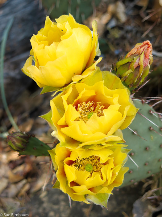 Prickly pear near junction of Pine Creek and Old Boulder Mail Trail   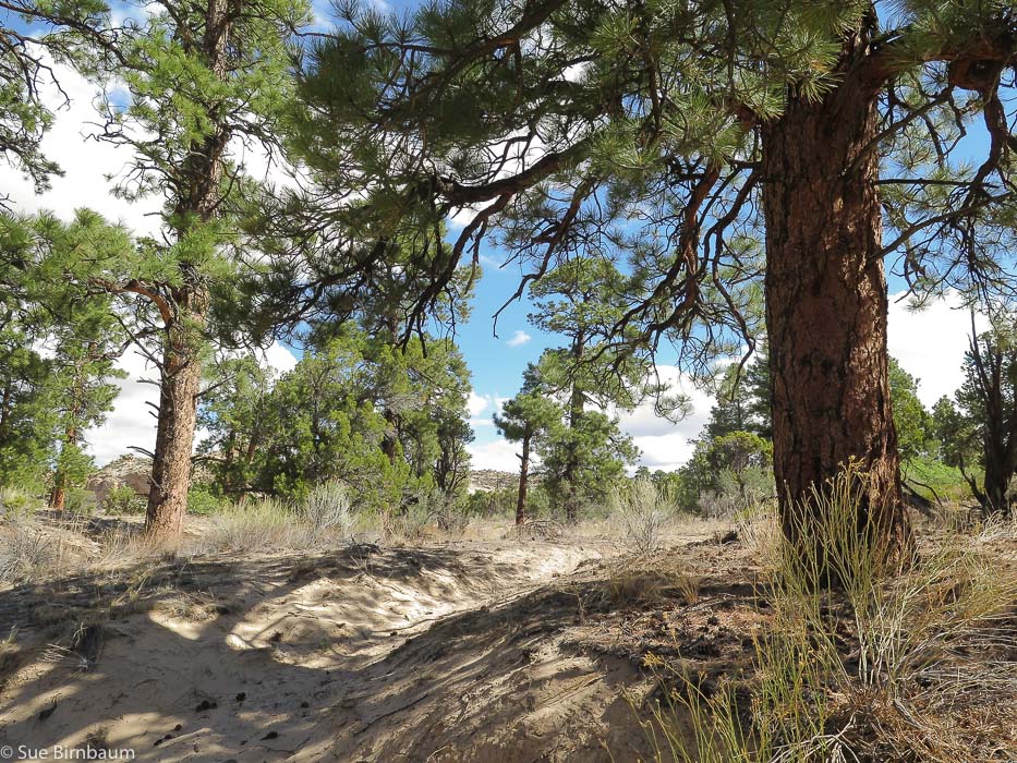 Heading up to Antone Flat 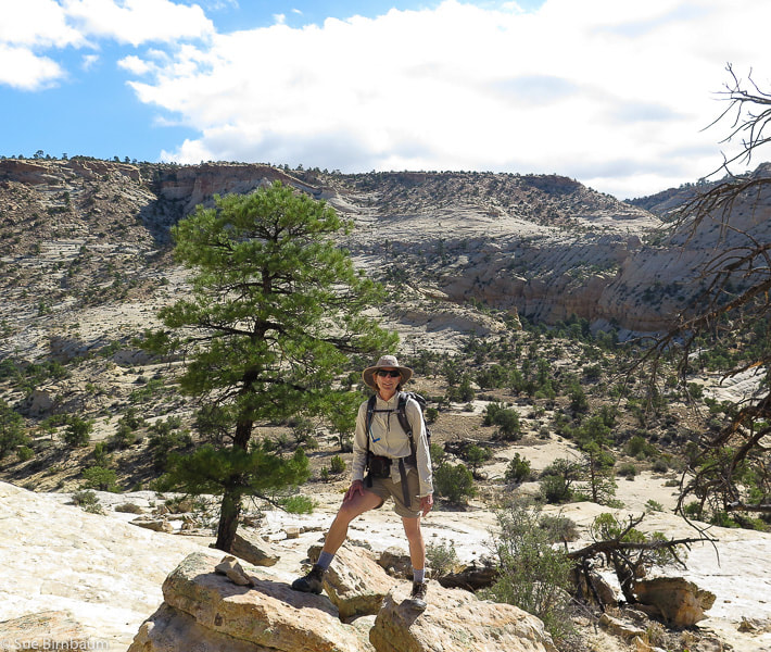 South end of Boulder Mail Trail from Escalante trailhead Trail goes to the left of large drainage and then treks to the right in this photo on the smooth portion at the base of plateau References:
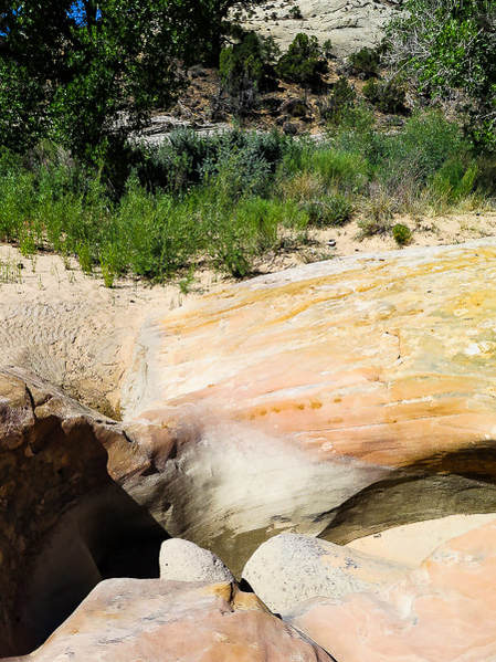
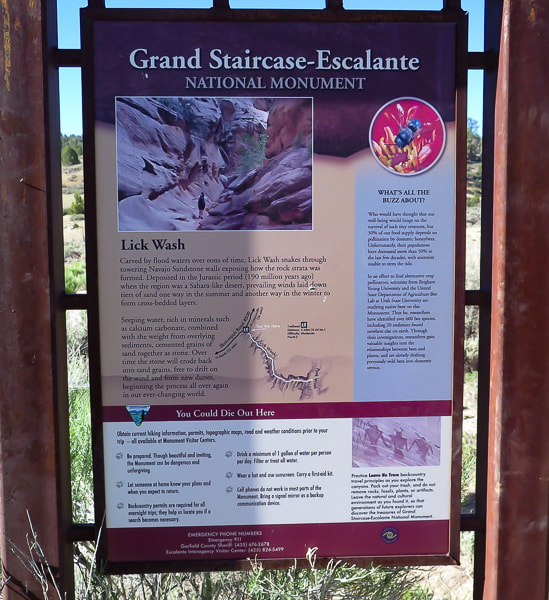
Boggs, S. Jr. 2012. Principles of Sedimentology and Stratigraphy, Fifth Ed. Pearson Education, Inc. Hackman, R.J., and Wyant, D.G., 1973, Geology, structure, and uranium deposits of the Escalante quadrangle, Utah and Arizona: U.S. Geological Survey, Miscellaneous Geologic Investigations Map I-744, scale 1:250,000. Parry, W. T. 2016. Geology of Utah's Mountain, Peaks and Plateaus. Friesen Press, Victoria, B.C., Canada. Roundy, J. C. 2000. "Advised them to Call the Place Escalante". Art City Publishing, Springville, Utah. 355 pp. UtahGeology.com. http://utahgeology.com/bin/formationdescs.php?fm=fm_navajo. A unique opportunity to see a near-relict, pristine desert ecosystem on the most inaccessible mesa in Grand Staircase - Escalante National Monument: No Mans Mesa, accessed from Lick Wash trail is solitary, remote, and undisturbed. 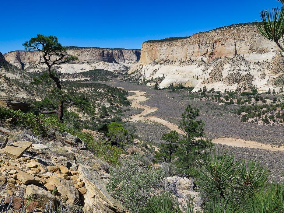 View of Park Wash and Navajo sandstone cliffs from rock fan of No Mans Mesa This hike follows the 4-WD road to the right of wash Trip Stats
"In sublimity - the superlative degree of beauty - what land can equal the desert?" - John C. Van Dyke
Lick Wash Trailhead sign 18 miles down Skutumpah Road; large ponderosa pine and Navajo Sandstone walls ~ 1/2 mile down Lick Wash 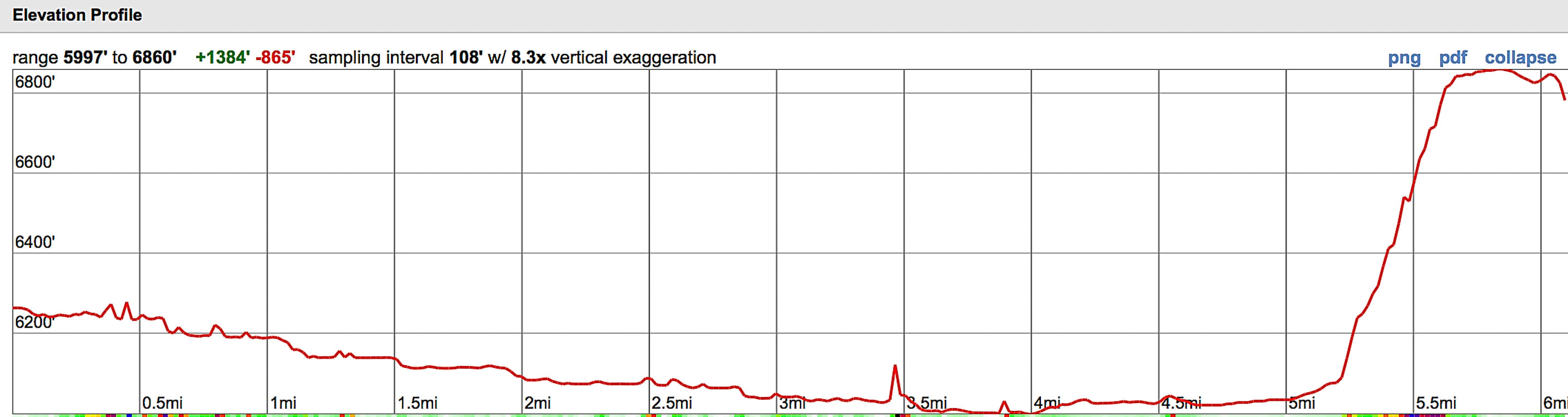 Hike elevation profile - Lick Wash trailhead to top of No Mans Mesa Route travels southeast down Lick Wash, then meets with Park Wash to travel northeast to northern tip of No Mans Mesa 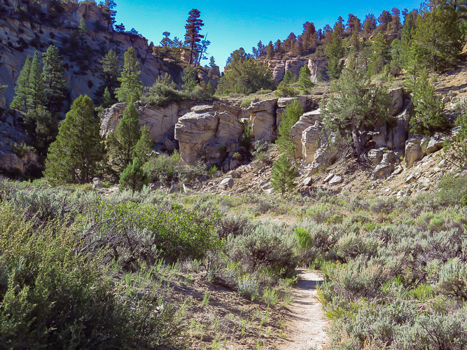 Entrance into Lick Wash, shortly after trailhead 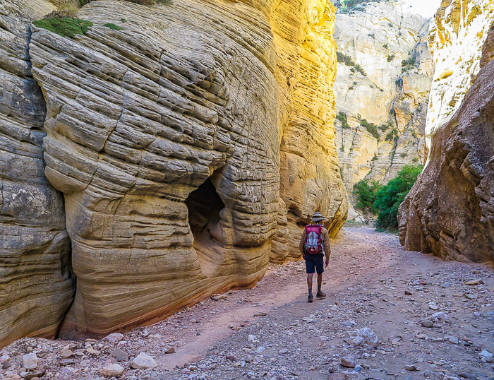 Towering sandstone walls dominate on the first mile of Lick Wash hike I was excited to get to the top of No Mans Mesa, since I do field work surveying ecological sites, work on conservation of a rare plant, and volunteer for habitat restoration. Fred and I had attempted to hike to this mesa 3 years ago, but the condition of Skutumpah Road was too risky after a few rainstorms. At a bend in Lick Wash about 2.5 miles from the trailhead, after steep walls had given way to a wider, less-constrained channel, Fred and I got our first view of No Mans Mesa. It's long length and towering 1,200-foot white walls were just emerging from morning shadows. Like a fortress it stood, looking impenetrable, at least to this first view. There's a small passage, however that climbs through the walls to the top, and we were hoping to find it. The next goal for this journey was to find the intersection of Lick Wash and Park Wash, and locate the trail that would take us past the LeFevre line cabin, through the sagebrush flat of Park Wash, then to the bottom of the rock debris fan located on the north side of No Mans Mesa in Grand Staircase-Escalante National Monument. We had driven 18 miles down Skutumpah Road to the Lick Wash trailhead and hiked the wash in a southeastward direction. I was prepared with the excellent hiking route directions from the website Earthline: The American West. Sure enough, at 4.0 miles, we reached the large Park Wash that continues the hike in a northeast direction between the walls of Calf Pasture Point and No Mans Mesa. Massive white Navajo Sandstone walls of Calf Pasture Point kept us in shade but only briefly, then we merged into the blazing sunlight of wide Park Wash, walking on a sandy trail that shortly intersected with an even sandier four-wheel-drive road. What a unique place to be in this remote wilderness! We trudged up the road that parallels the wash to the first shade we could find under a juniper and took a break. It was here that we saw what was unmistakably the rock debris fan that we would have to ascend. 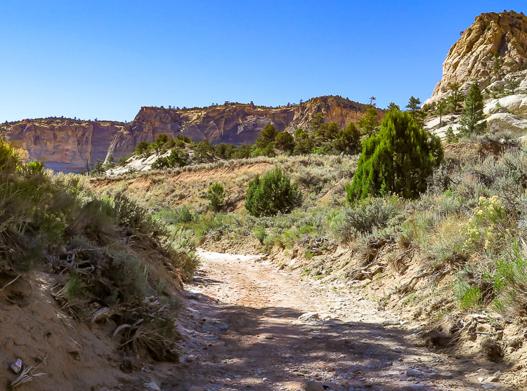 First view of No Mans Mesa 2.5 miles down Lick Wash 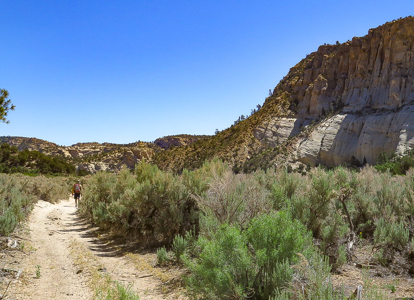 View of debris fan (rockslide) on northernmost point of No Mans Mesa from 4-WD road At 4.5 miles into the hike, we reached the dramatic scene of the LeFevre cabin dwarfed against the bleached Navajo Sandstone overhang of Calf Pasture Point, and tucked under ponderosa pines. At ~ 4.9 miles, trudging in the sand, we passed a fence line, walked a few more minutes and found a defined stock (and human?) trail leading toward the debris slide. We crossed deep Park Wash, wove around sagebrush and found ourselves at the bottom of the debris fan. The top of the steep cliffs was 800 feet above, and we tried to locate our only passage to the nearly pristine crest of No Mans Mesa. We followed a faint trail and located our first rock cairn trail marker a few hundred feet up the rock slide and after this, the cairns were usually easily seen and numerous enough to follow the trail (June 2018). Back and forth the trail switchbacks to the top of the fan. The transition point from exiting the debris fan to entering the steep cliff walls is a rock "bridge" ~ 20 feet across with a steep and loose gully tumbling down to the right.  LeFevre cabin in Park Wash - 4.5 miles from Lick Wash trailhead 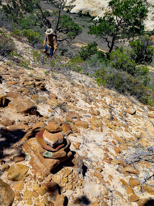 Cairn marking trail up debris fan. Park Wash with trail below Eroded bedding provides a staircase as you walk on more solid ground. The trail gets steeper and more exposed. Stunning views open up. It appears that in some places sandstone has been chiseled to make the trail, probably by Jepson, the goat herder in 1927. From the wash floor, the cliff walls looked impenetrable - now we were squeezing through the only known passage to the top. Then suddenly we were taking the first steps into the relict, almost surreal world of No Mans Mesa with its relatively long and flat terrain, nothing but blue sky above. Savoring each step, we took a break in pinyon pine shade near a ledge of burnt orange rock with hints of blue-grey - part of the Carmel Formation. Many wildflowers were in seed. There were no cheatgrass seeds getting stuck in my socks, only open bright sand weaving around healthy bunch grasses and small sand dunes sprouting native Arizona thistle. On a short walk around the top, I found chert debitage, a white rock flake that shows evidence of stone tool-making. Surprised by the presence of sand dunes, I then realized that in fact, Navajo Sandstone was created by deposition of wind-blown sand into large dunes (eolian environment). It was originally red: it was turned to a brilliant white color after reducing fluids dissolved the iron oxide from the grains of the deeply buried sandstone.  Trail shortly after crossing "bridge" between talus of debris fan and entrance into cliff rocks  Nearing top through break in cliff to No Mans Mesa 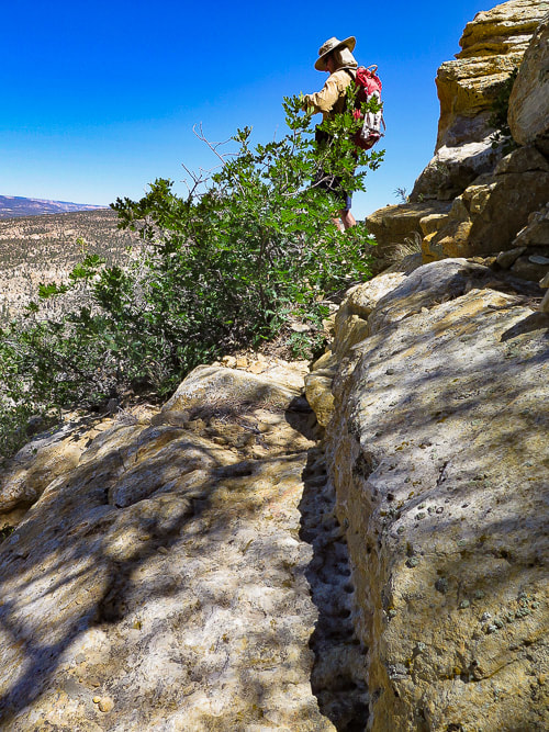 Trail appears to be chiseled into the rock at a few places 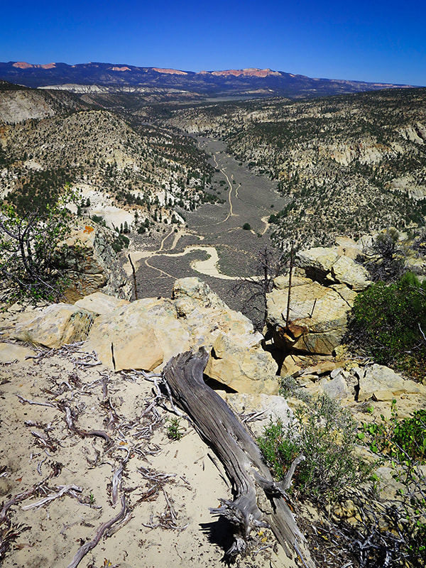 Finally at the top! View from top of No Mans Mesa of Park Wash and Pink Cliffs For the Phytocurious According to the study A Comparison of a near-relict site and a grazed site in a pinyon-juniper community in the Grand Staircase National Monument, Utah, no non-native species were found on the study plots on No Mans Mesa. This study compares vegetation species cover and richness, cryptobiotic crust cover and soil on No Mans Mesa and Deer Spring Point, ~ 2 km southwest of No Mans Mesa. Deer Spring Point is accessed by a road branching from Skutumpah Road and is grazed in the summer by domestic livestock. Characteristics for these two study sites are similar: same geology, elevation, soil, aspect and plant community type. Major findings comparing plant communities in the grazed site and the non-grazed, near-relict site:
In our short exploration at the top, I was aware of just about every step on that isolated, ecologically "pure" mesa elevated above lands that held invasive plants in this remote wilderness. I felt I was taking steps about 200 years back in time before invasive species were introduced. Reluctantly, I walked out of that beautiful land and committing to memory what this place looks like. We found our steep entrance and hiked down past the rusty mangled fence that Jepson must have used to keep his goats on the mesa. Still not a cloud in the sky on this mid-June day. White wash and trails curved their way through the dark sagebrush flat 800 feet below us. This time, as we neared the lower section of the debris fan, we veered north and found a less rocky and more sandy descent to the valley floor. By this time we were hiking in full blazing sun - it was getting pretty darn hot. Pausing to rest under any shade we could find, we bypassed side canyons that would have to wait until next time. At last we reached the cooler narrows of Lick Wash and shed our sweat-soaked shirts for awhile. I wish I were in the shade of those sandstone walls, sliding my hands over the ancient and eroded beds, hearing the crunch of the purple-hued trail, and smelling the ponderosa pines. We will be back here, but time keeps ticking. A recently retired friend, talking about his planned adventures, said to me, "I don't know if I have enough money, but I sure as hell don't have enough time!" How true. 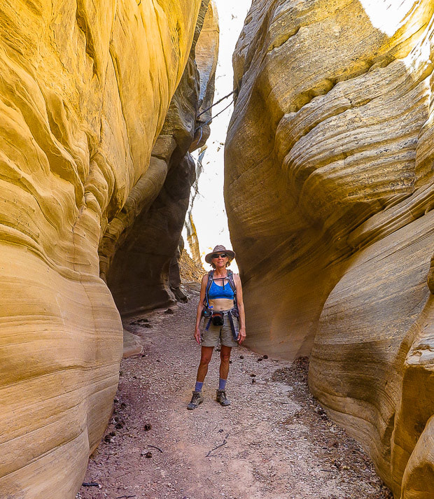 Lick Wash narrows 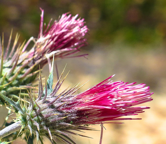 Native Arizona thistle 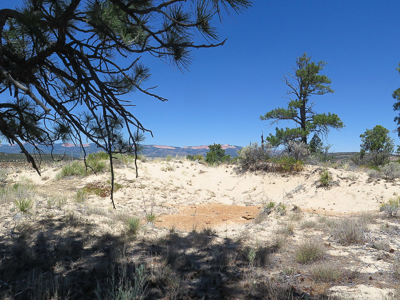 Sand dune! Northern No Mans Mesa 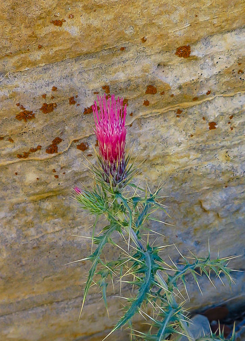 Arizona thistle (Cirsium arizonicum) against Navajo Sandstone No Mans Mesa  Loamy sand of No Mans Mesa 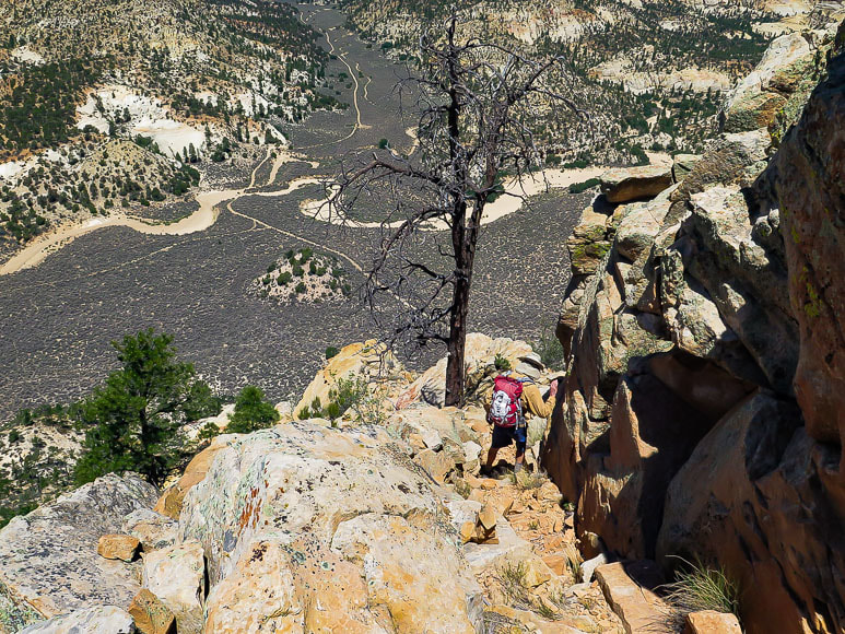 Making our way down - a few loose rocks  North tip of No Mans Mesa Ascend left side (northernmost point) 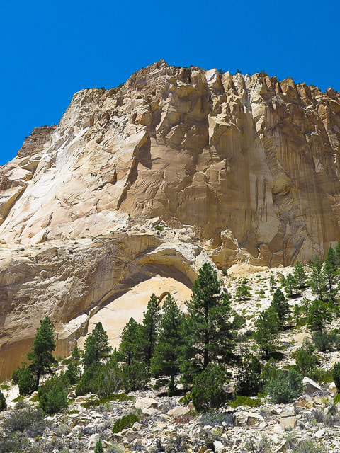 Navajo Sandstone cliffs of Calf Pasture Point  References:
Atkison, Ron. Hiking Grand Staircase-Escalante and the Glen Canyon Region. 1998. Falcon Publishing. pp 288-292. Gregory, Herbert E. 1951. The Geology and Geography of the Paunsaugunt Region Utah. Geological Survey Professional Paper 226. United States Government Printing Office. Guenther, D., Stohlgren, Thomas J., Evangelista, P. 2003. A Comparison of a near-relict site and a grazed site in a pinyon-juniper community in the Grand Staircase National Monument, Utah, In book: The Colorado Plateau: cultural, biological and physical research. The University of Arizona Press, pp. 153-162. Mason, Lamar R., Andrews, Horace M., Carley, James A., Haacke, E. Dwain. 1967. Vegetation and Soils of No Man's Mesa Relict Area, Utah. Journal of Range Management 20: 45-49. This beautiful hike in the less-visited Kolob Canyons district of Zion National Park packs in a lot of geology, history and glowing sandstone colors for such a short hike. Related: Mt. Kinesava hike - Zion National Park Angels Landing in Zion: Not for the Faint of Heart Utah's Red Rock Country Desert Plant Photos Trip Stats: Location: Double Arch Alcove lies at the end of Middle Fork of Taylor Creek hike in the Kolob Canyons section of Zion National Park. This hike ends at the lower arch alcove; there is an arch above this, hence the name double arch alcove. Difficulty: easy - moderate class 1. Distance/Elevation Gain: 6.0 miles out and back, 500' elevation gain to double arch alcove. Trail head: 2 miles past the Kolob Canyons Visitor Center and Kolob Canyons Road within Zion National Park. Geology: Geologic features such as tilted and chevron-folded sediment layers and marine fossils in limestone can be seen on the way to double arch alcove. This trail traverses the Taylor Creek Thrust-Fault Zone and goes through 3 geologic formations as you climb. Some of the features are: Petrified Forest Member of the Chinle Formation, Moenave Formation (including the Kanarraville fold), Kayenta Formation and ending in Navajo Sandstone. History: 2 homestead cabins are located on this trail - both built in 1930. Best time to hike: Early morning light in this box canyon is beautiful due to sun reflections off towering Tucupit and Paria Points that reflect orange light. We like hiking this trail in the fall.  Double Arch Alcove, Kolob Canyons, Zion National Park  Navajo Sandstone of the Double Arch Alcove - Kolob Canyons - Zion National Park Taylor Creek Trail to Double Arch Alcove contains a treasure-trove of exposed geologic features in a relatively short distance. In the 450 feet of elevation from trailhead to alcove, the hike passes through three geologic formations. Like most box canyons, the hike starts at the lower, wider part of the canyon and climbs to narrower, higher walls on both sides. The towering wall seen from the north side of the canyon is Tucupit Point, and the wall seen from the south side is Paria Point. The hike ends at the alcove carved into Navajo Sandstone. Geology aside, you can enjoy the sheer beauty of this hike because of the creek's waterfalls, the pines and junipers, and the colors and patterns on the rock. The Larson homestead cabin, built in 1930, lies at the confluence of the Middle Fork and North Fork of Taylor Creek. The Fife homestead cabin is located further up the trail. Both are preserved well, and you can imagine what it might be like living through cold winter nights in this canyon. Early morning is the best time to hike along the Middle Fork of Taylor Creek to Double Arch Alcove because of the quality of the light. As the rising sun shines on towering red rock walls along the creek, it reflects an orange glow onto everything in the canyon. I feel like I'm enveloped in a soft light that relaxes me as I hike further. Everything is still, devoid of harsh shadows and colors are vibrant. The orange sand is soft underfoot and the creek crossings don't create an interruption in our stride. 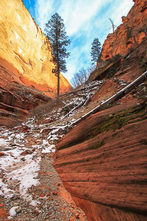  Small pond near creek where leaves were slowly circling together in a counter-clockwise direction  Chevron fold seen in Middle Fork Taylor Creek in the Dinosaur Canyon member of the Moenave Formation - note chevron structure of folds due to compressional stresses placed on the rock During the Mesozoic Era, Western North America was in a mountain-building phase with compressional forces due to the Pacific Plate sliding underneath the North American Plate. The rocks of the Kolob Canyons were squeezed, compressed and uplifted. In the Middle Fork Taylor Creek Canyon, this resulted in the Taylor Creek Thrust-Fault Zone and the Kanarraville Fold. The photo above was taken on Thanksgiving 4 years ago when Fred and I first hiked this canyon.  Gray limestone with bivalve fossils probably from the lower Carmel Formation 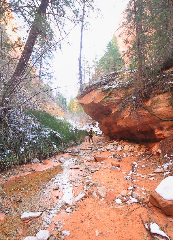  Gustive Larson Cabin built in 1930  Early Morning in Late November Taylor Creek - Kolob Canyons  Reflection from Tucupit Point into Middle Fork of Taylor Creek 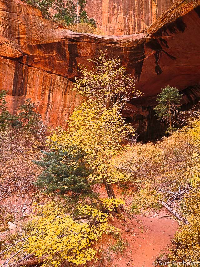  Middle Fork of Taylor Creek - Kolob Canyons - Zion National Park  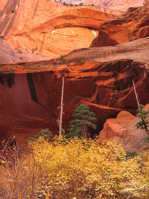 Double Arch Alcove  Maidenhair fern on moist sandstone wall The scenery becomes more intense as you walk up the canyon. Then suddenly a wall of orange and red Navajo sandstone with black mineral stains looms above. The lower arch provides a wide alcove with water seeping from its walls. This is in fact what probably the impetus for the lower arch formation. Ground water seepage weakens and dissolves the cement between sandgrains, breaking down the sandstone. Blocks of sandstone then fall from the arch, accumulating below it only to be carried away by wind and water. The blind upper arch appears high above the lower arch. The whole scene is enveloped in a warm orange glow that is a reflection of light from the north canyon wall. The terrain is devoid of footfalls because of the soft orange sand. The green trees contrast with the orange and red. And to have some snow along the way as we did when we hiked this trail on Thanksgiving 2013 was an added bonus.  Yucca in Snow Canyon State Park near St. George, Utah References: Biek, R. F., Geologic Trail Guides to Zion National Park, Utah - Kolob Canyon Trails - Middle Fork of Taylor Creek Trail. Utah Geological Survey https://www.utahgeology.org/road_logs/uga-29_first_edition/NP_guide/ziontrai.pdf Website - "Watching for Rocks - Travels of a Sharp-eyed Geologist". Blog post April 21, 2011 http://www.watchingforrocks.com/2011/04/folding-and-faulting-in-kolob-canyons.html Website - "Zion National Park - Plate Tectonics" http://zion-gardner-bosch.weebly.com/plate-tectonics.html Trip Stats:
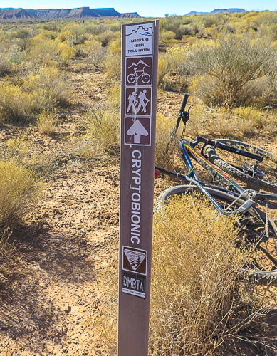
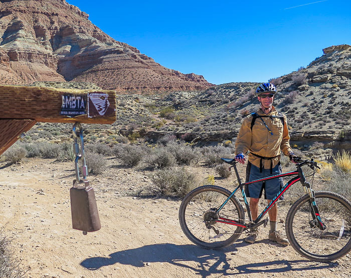 Fred at cowbell at top of Dead Ringer trail climb Last weekend Fred and I got out of our Boise mountain bike trail comfort zone and rode some Utah trails near Hurricane. The Boise ride we're used to is a steady gravelly climb up of mostly non-technical trails. Although this ride was not technical, we found our legs getting adjusted to riding over blocks of limestone and up and down roller-coaster-like arroyos and small hills that ran along the base of towering cliffs and then out into a valley. These trails were singletrack cruisin' and so fun as to bring a grin to our faces. Utah bikers must have a "soft tail" or a suspended seat post, we concluded. But we talked to a few other bikers and they all said they thought their hard tails were actually better. So, we concluded that our bikes are just fine and we need to get down to Utah for more mountain biking. The terrain can be challenging and it is so beautiful! The initial descent down J.E.M. trail that puts you riding alongside a gorge was a little sketchy for me, so I walked a few of the steep switchbacks, while two young and fast kids whizzed past and out of sight (maybe I've seen too many physical therapy patients with broken bones and sprained ligaments as a result of bike crashes!). 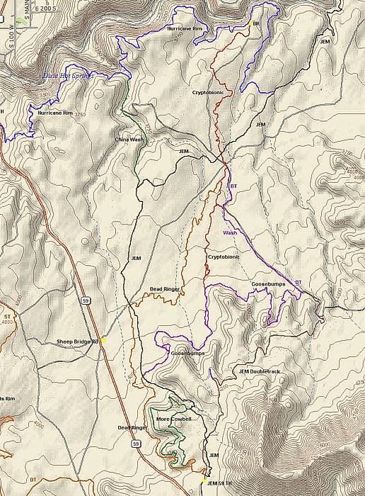 Trails from J.E.M. trailhead (bottom of map) in the Hurricane Rim trail system, near Hurricane, Utah Our Loop ~ 10 miles (J.E.M., Goosebumps, Cryptobionic, Dead Ringer and More Cowbell trails)
Cryptobionic trail sign and cryptobiotic soil It seemed fitting that in a sea of cryptobiotic soil we would be riding on Cryptobionic trail. We admired the "geology-mindedness" and a play on words that the trail builders provided us. Cryptobiotic soil crusts consist of soil cyanobacteria, lichens and mosses. In arid areas, these crusts help prevent soil erosion, increase water infiltration, and are good sources of fixed carbon. A large percentage of the soil in this trail system had cryptobiotic crusts. One source I read said that it takes an estimated minimum of 45 years to for damaged cryptobiotic soil in Southern Utah to be restored if crushed. 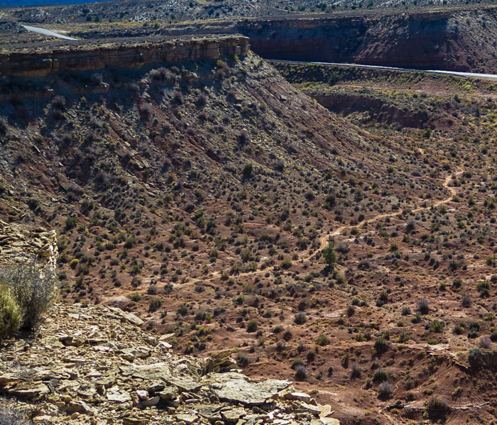 Dead Ringer trail leading south toward J.E.M. trailhead and cowbell The cowbell hanging from a post at the top of Dead Ringer trail is within easy reach as you get to the top. As we took a break at the top, several bikers hit the bell as they rode past it. The story, we heard is that the cowbell was found on/near a cow skeleton while the trails were being built. At the cowbell, you can keep going to the trailhead or you can take a left and cruise on More Cowbell trail. Of course, we opted to keep cruisin' on this great trail that traces the edge of the mesa we had just climbed. 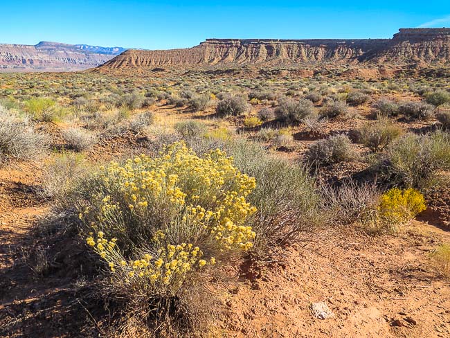 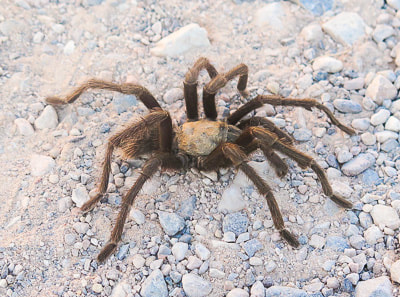 Tarantula on gravel road in Snow Canyon State Park 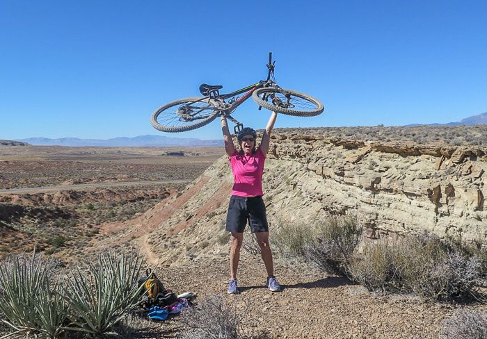 The joy of riding More Cowbell trail and the beautiful single track behind me! So much to explore in the St. George, Utah area, so little time. We'll get back on these trails, that's for sure! Longer loop next time! Reference:
Belnap, J., Cryptobiotic Soils: Holding the Place in Place https://geochange.er.usgs.gov/sw/impacts/biology/crypto/ Breathtaking view of Zion Canyon in Zion National Park; if you don't mind steep drop-offs, this hike's for you! Trip Stats:
 Top of Angels Landing - Zion National Park Looking down Zion Canyon 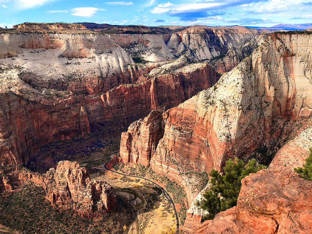 View of Zion Canyon from Cable Mountain, Zion National Park Angels Landing lower left Utah's Red Rock Country Angels Landing, the summit of a towering slab of orange and yellow Navajo Sandstone rises almost 1,500 feet from the floor of Zion Canyon in Zion National Monument. At first glance, it looks as if someone took a flat chunk of rock and tilted it up 90 degrees to rest on its side; however, if you study the rock more closely, you can see the relatively horizontal cross-bedding of sand layers that were laid down 180 million years ago. When you stand at almost the highest elevation in the park, Observation Point, you can look down onto Angels Landing, 700 feet below your boots. From this vantage point, Angels Landing is a fin of vertical sandstone. From any vantage point, it seems impossible that there would be a hiking trail to the top, but in fact, people have been hiking Angels Landing since the trail was built in 1926. 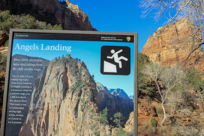 Warning sign at the West Rim trailhead in Zion Canyon, with Angels Landing in background Fred and I were fortunate enough to hike Angels Landing the Monday before Thanksgiving. We were trying to remember how many times each of us had been to the top. I did my first Angels Landing hike nearly 20 years ago, and Fred the same. We have done it about 3 or 4 times since, and each time we are reminded what a special and spectacular hike it is. However, 20 years later, a lot more people know about the trail, and it has become a destination for many a Zion hiker. At the trailhead, a sign warns hikers of the perils that lie ahead. The sign reads: “Since 2004, six people have died falling from the cliffs on this route. The 1.1 mile round-trip route from Scout Lookout to Angels Landing is a strenuous climb on a narrow ridge over 1,400 feet above the canyon floor. This route is not recommended during high winds, storms, or if snow or ice is present.”  Waterfall in Refrigerator Canyon in November 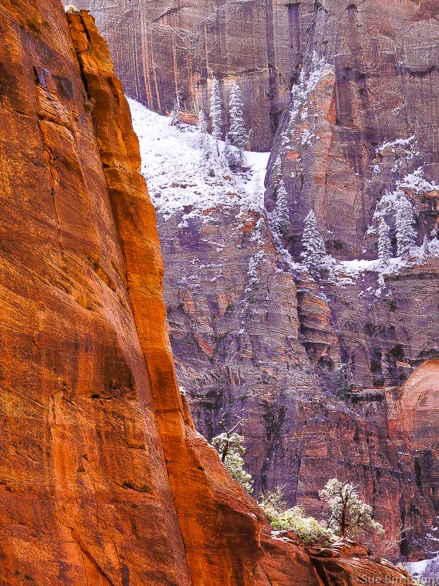 Base of Angels Landing in Zion National Park as viewed from West Rim Trail After hiking a short distance along the Virgin River, the erosive force mostly responsible for the creation of Zion Canyon, the trail ascends steeply up switchbacks to enter Refrigerator Canyon. I can see how this canyon got its name because even in warmer months, it is still a cool and welcome change from the sun-baked trail below. While still in this canyon, the next task is to hike up through “Walter’s Wiggles”, named for Zion’s first superintendant, who helped build the trail in 1926. There are 21 short, very steep, heart-pounding switchbacks. Upon exiting Refrigerator Canyon and the “wiggles”, the first close-up view of the vertical walls of Angels Landing comes into view. It is here that your heart pounds for a different reason: there before you lies a spectacular site of a narrow straight-up trail with lots of people holding onto thick metal chains that have been placed on most of the route. 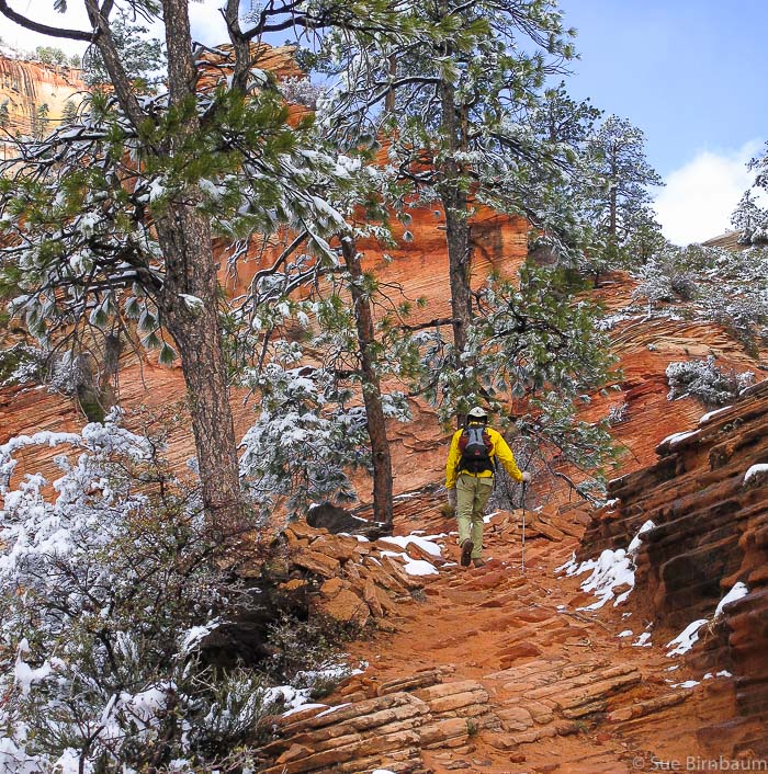 West Rim Trail past Scout Lookout and the trailhead to Angels Landing 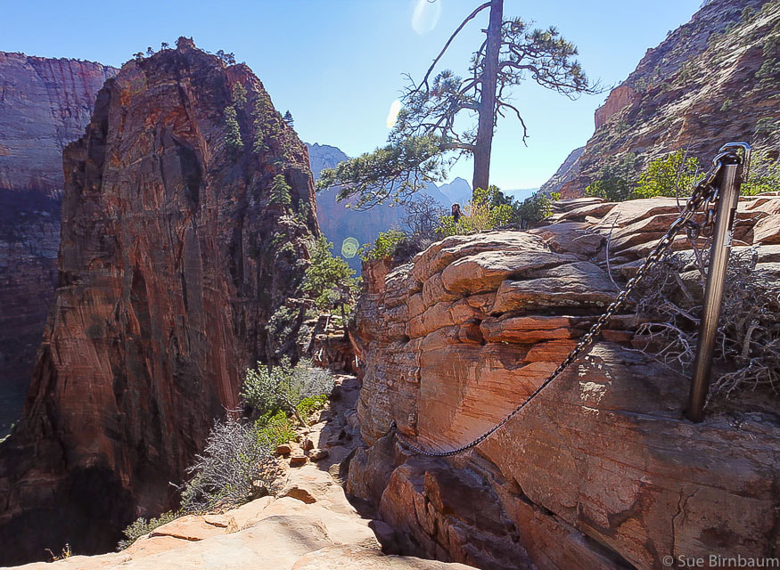 Heavy steel chain bolted into sandstone - Angels Landing at left on top of sandstone fin  The final climb The chains drilled into the sandstone make this exposed, dizzying hike much more manageable. In fact, there was a trail crew working on the chains, replacing some clamps that attached the chains to the poles. As we waited for them to complete their task, I made sure not to look at the 1,200 foot sheer drop-off just a few feet to my left. 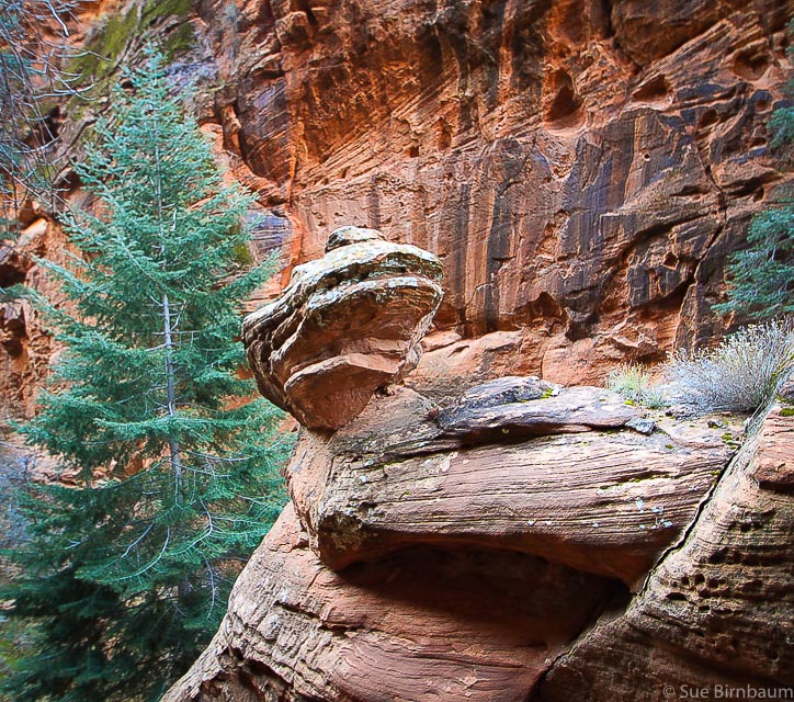 Refigerator Canyon with cross-bedded sandstone 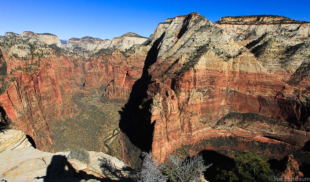 On Angels Landing - view to the north, toward the narrows of the Virgin River Oh glorious summit! The reward is worth the guts, nerves, and courage of the adventurer. There are about 15 people on the sun-drenched summit, all smiling and taking photos. To the north, the Virgin River snakes through the top of the canyon, and to the south, famous Zion Canyon landmarks can be seen, such as the Great White Throne. 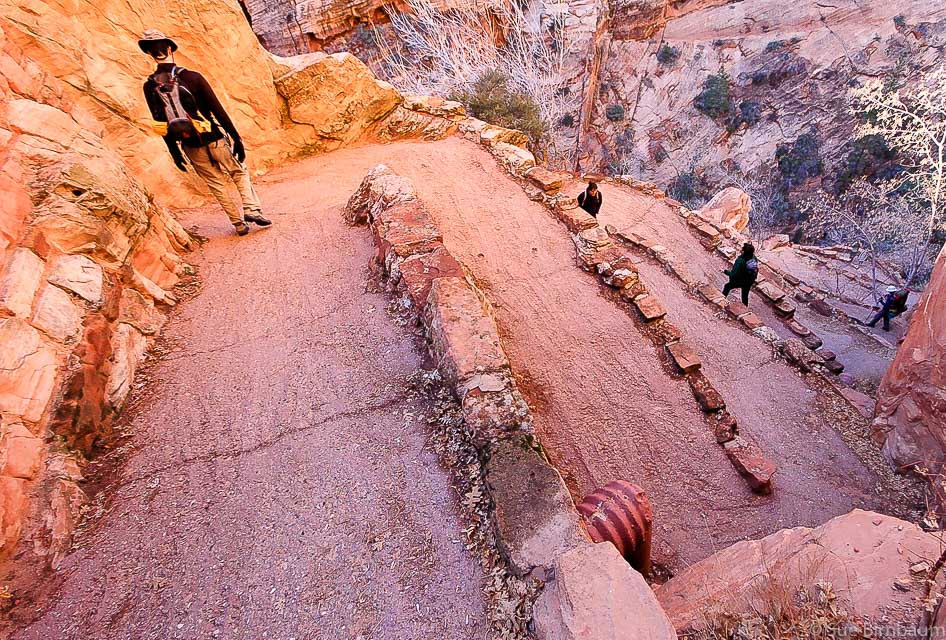 Fred walking down Walter's Wiggles - switchbacks in Refrigerator Canyon named after Zion's first superintendent, who helped build this trail in 1926 Zion Canyon is the remnant of ancient sand dunes that covered a huge portion of North America, and formed about 175 million years ago. It is at Zion that these ancient sand dunes are the greatest thickness.
We head back down, and find many more hikers coming up, and since trail etiquette dictates that uphill hikers have the right of way, we pause a few times to encourage climbers. At one point, a woman sees what lies ahead of her and wants to turn back, muttering something about just eating lunch. I tell her that “it’s not as bad as it looks” and she bravely goes on. Because it’s true, it’s really not as scary as it looks. We will be back someday. |
Categories
All

Sue and Fred

About this blogExploration documentaries – "explorumentaries" list trip stats and highlights of each hike or bike ride, often with some interesting history or geology. Years ago, I wrote these for friends and family to let them know what my husband, Fred and I were up to on weekends, and also to showcase the incredible land of the west.
To Subscribe to Explorumentary adventure blog and receive new posts by email:
Happy Spring!

About the Author
|