EXPLORUMENTARY
  • Home
    • Cactus to Clouds Hike
    • More Quotes
    • Ann Zwinger Quotes
    • Mary Oliver Poems
  • Hikes by State
    • Idaho
    • Southern Utah
    • Arizona
    • California Desert
    • Nevada
    • Wyoming
  • BLOGS
    • Adventure Blog
    • Women and the Land
  • GALLERY
    • DESERT PLANTS >
      • Beavertail cactus
      • Brittlebush
      • Christmas Cactus
      • Arizona Barrel Cactus
      • Parry's penstemon
      • Agave
      • Arizona Rainbow Hedgehog
      • Claret Cup Hedgehog
      • Desert Agave
      • Palmer's Penstemon
      • Silver Cholla
      • Cristate Saguaro
      • Indian Paintbrush
      • Ocotillo
      • Santa Rita Prickly Pear
      • Spiny Cliffbrake
      • California Barrel Cactus
      • Engelmann Prickly Pear
      • Velvet Mesquite
      • Joshua Tree
      • Buckhorn Cholla
      • Hedgehog Cactus
      • Fishhook cactus
      • Thompson's Woolly Locoweed
    • NATURE
    • BOISE
    • EARTH + SKY
    • URBAN
    • WATER
    • PATRIOT
    • ORCHIDS
  • Fit After 50
    • Brian Holgate
    • Fred Birnbaum
    • Dave Brasuell
    • Bus' Little Black Book
    • Mike Carlson
    • Ray Wilson
    • Bryan Krouse
    • Vickie Kearney
    • Maria Keezer
    • DOUG TRAUBEL
    • Boise Cross Fit Masters Ladies
    • Tim Clemens
    • Marcia Bondy
    • Becky Borczon Blake >
      • Becky B Downtown
    • Jennifer Cera and Sue Birnbaum
    • Dave Brasuell
    • Vance Powell
  • About
    • CONTACT

No Mans Mesa hike in Grand Staircase - Escalante National Monument

7/21/2018

7 Comments

 
A unique opportunity to see a near-relict, pristine desert ecosystem on the most inaccessible mesa in Grand Staircase - Escalante National Monument:  No Mans Mesa, accessed from Lick Wash trail  is solitary, remote, and undisturbed.​
Picture
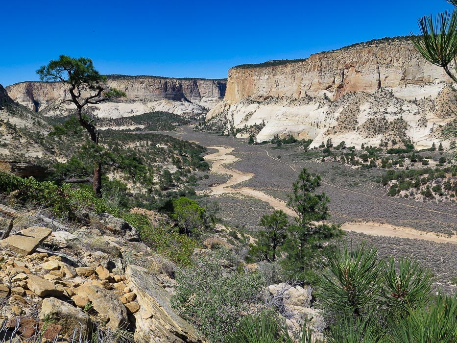
View of Park Wash and Navajo sandstone cliffs from rock fan of No Mans Mesa
This hike follows the 4-WD road to the right of wash
Trip Stats
  • Overview:  Challenging and memorable hike with spectacular views of Grand Staircase-Escalante National Monument and the unique experience of witnessing a nearly untouched environment.  Begin by walking down Lick Wash through dramatic carved sandstone to Park Wash, walk past Le Fevre line cabin, then northeast toward the moderate - strenuous climb through the only entry onto No Mans Mesa.
  • CAUTION:  To keep this area's wonderful ecology as it is, make sure that your gear and boots are free of vegetation and seeds before entering it.
  •  Distance:  12 miles out and back to entrance of No Mans Mesa
  •  Elevation gain:   Trailhead at 6,259 feet, intersection of Lick Wash and Park Wash at 6,013 feet, entry into No Mans Mesa at 6,827 feet:  Gain from intersection to No Mans Mesa = 814 feet.
  • Difficulty:  Class 1 in washes, strenuous Class 2 and 3 with unstable rocks with moderate exposure on debris fan ascent to No Mans Mesa.  Only hikers experienced with steep loose rock and route-finding should attempt this hike.
  • Navigation:   Topo maps and experience with navigation skills strongly recommended.
  • Maps:  Trails Illustrated Topographic Map for Grand Staircase/Paunsaugunt Plateau (# 714), USGS topo map for Deer Spring Point, Utah
  • ​Best seasons:  April - early June, September - October
  • Directions to trailhead:​  From Utah Scenic Byway 12 in Cannonville, 36 miles west of Escalante, travel south on Cottonwood Canyon Road.  The sign on UT 12 reads "Kodachrome Basin - 9". Drive 2.8 miles to Skutumpah Road which travels south/southwest.  At this intersection, zero-out your odometer.  In 3 miles, cross Sheep Creek; in 5.5 miles, bear left at the intersection with BLM road 530.  Pass the Willis Creek Trailhead in 6.2 miles and the Bull Valley Gorge trailhead in 8.8 miles.  Lick Wash trailhead is at mile 18 miles down Skutumpah Road.  Parking area to left of road.
  • Hike directions:​  1.  Lick ​​Wash trailhead to intersection with 4-WD road in Park Wash at ~ 4.0 miles.  After emerging from Lick Wash, follow trail that rounds under Calf Pasture Point to the left and eventually parallels road in ~ .2 miles.    2. Hike this road northeast up Park Wash, pass LeFevre cabin at 4.5 miles.  Pass fence line at ~ 4.9 miles.  3.  Shortly after fence, follow major stock trail through sagebrush to your right toward debris fan on the northernmost point of No Mans Mesa, crossing deep Park Wash.  4.  Climb rock fan ~ 200 feet to locate first rock cairn.  Follow the frequent cairns (as of June 2018) to the top paying close attention due to risk of exposure and steep drop-offs if you get off course.
  • Geology:  No Mans Mesa is described as an erosion remnant on a terrace in the Paunsaugunt Plateau.  The cliff walls are of Navajo Sandstone (190 - 174 Ma), the top is capped by erosion-resistant limestone/mudstone/sandstone of the Carmel Formation (160 Ma).  Soil texture is loamy sand.
  • History:  Probably native peoples accessed No Mans Mesa (I found debitage chert).  Jepson, a local rancher, cut the trail that we follow today in order to graze his goat herd in 1927 and 1928.
  • CAUTION:  Skutumpah Road can be hazardous after a rain storm which makes the bentonite clay surface dangerous to travel.  This road is steep in parts and subject to wash-outs.​
"In sublimity - the superlative degree of beauty  - 
    what land can equal the desert?"

     -  John C. Van Dyke
Picture
Picture
Lick Wash Trailhead sign 18 miles down Skutumpah Road;  large ponderosa pine and Navajo Sandstone walls ~ 1/2 mile down Lick Wash
Picture
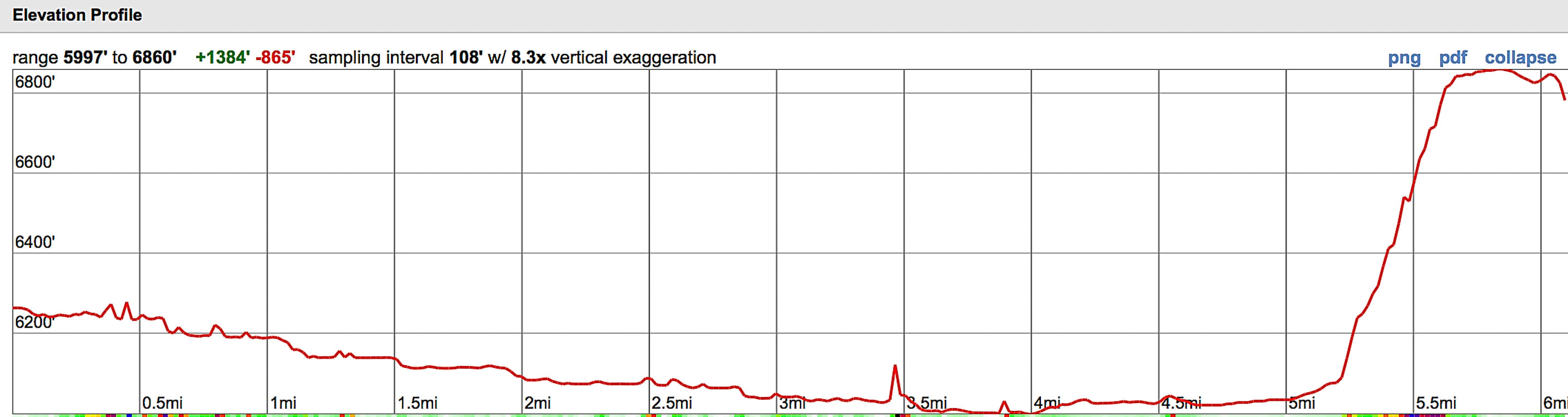
Hike elevation profile - Lick Wash trailhead to top of No Mans Mesa
Route travels southeast down Lick Wash, then meets with Park Wash to travel northeast to northern tip of No Mans Mesa
Picture
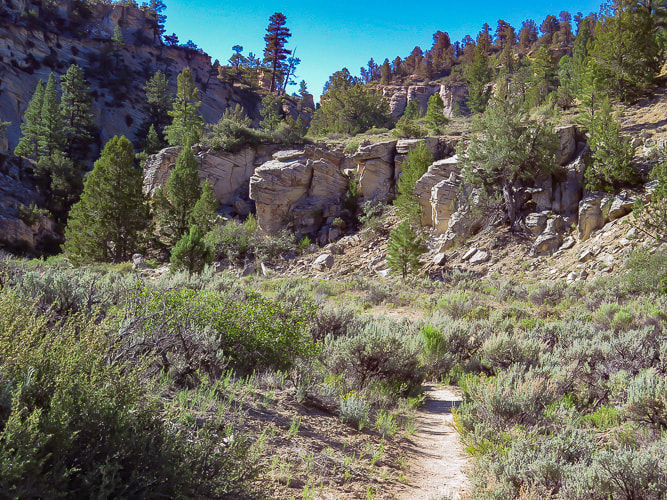
Entrance into Lick Wash, shortly after trailhead
Picture
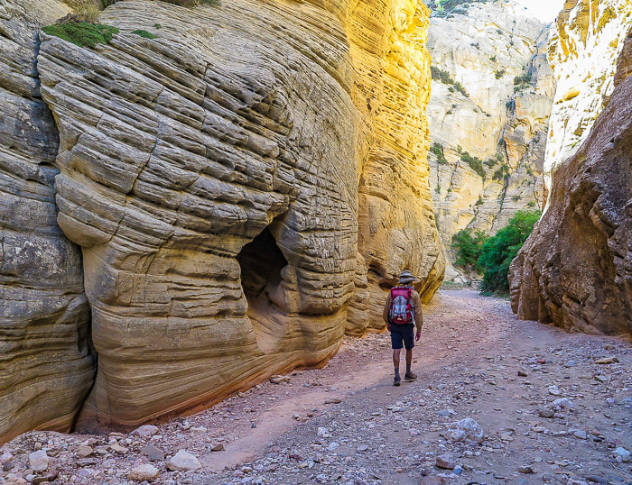
Towering sandstone walls dominate on the first mile of Lick Wash hike
I was excited to get to the top of No Mans Mesa, since I do field work surveying ecological sites, work on conservation of a rare plant, and volunteer for habitat restoration.   Fred and I had attempted to hike to this mesa 3 years ago, but the condition of Skutumpah Road was too risky after a few rainstorms.

At a bend in Lick Wash about 2.5 miles from the trailhead,  after steep walls had given way to a wider, less-constrained channel, Fred and I got our first view of No Mans Mesa.  It's long length and towering 1,200-foot white walls were just emerging from morning shadows.  Like a fortress it stood, looking impenetrable, at least to this first view.  There's a small passage, however that climbs through the walls to the top, and we were hoping to find it.  The next goal for this journey was to find the intersection of Lick Wash and Park Wash, and locate the trail that would take us past the LeFevre line cabin, through the sagebrush flat of Park Wash, then to the bottom of the rock debris fan located on the north side of No Mans Mesa in Grand Staircase-Escalante National Monument.


We had driven 18 miles down Skutumpah Road to the Lick Wash trailhead and hiked the wash in a southeastward direction. I was prepared with the excellent hiking route directions from the website Earthline:  The American West.  Sure enough, at 4.0 miles, we reached the large Park Wash that continues the hike in a northeast direction between the walls of Calf Pasture Point and No Mans Mesa.   Massive white Navajo Sandstone walls of Calf Pasture Point kept us in shade but only briefly, then we merged into the blazing sunlight of wide Park Wash, walking on a sandy trail that shortly intersected with an even sandier four-wheel-drive road.   What a unique place to be in this remote wilderness!  We trudged up the road that parallels the wash to the first shade we could find under a juniper and took a break.  It was here that we saw what was unmistakably the rock debris fan that we would have to ascend.
Picture
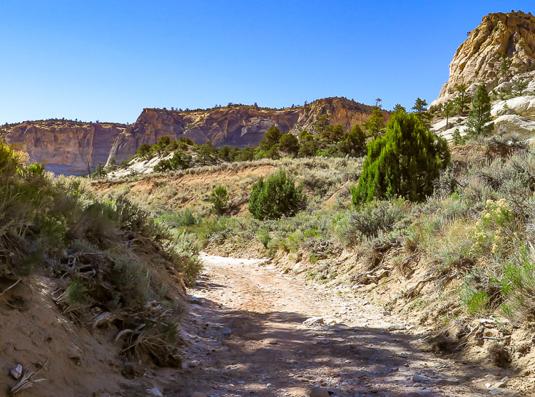
First view of No Mans Mesa 2.5 miles down Lick Wash 
Picture
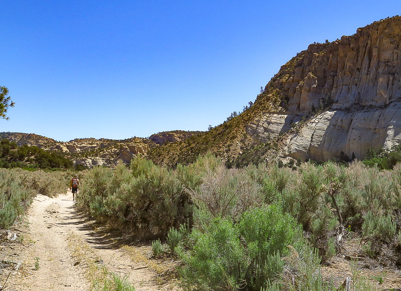
View of debris fan (rockslide) on northernmost point of No Mans Mesa from 4-WD road
At 4.5 miles into the hike, we reached the dramatic scene of the LeFevre cabin dwarfed against the bleached Navajo Sandstone overhang of Calf Pasture Point, and tucked under ponderosa pines.  At ~ 4.9 miles, trudging in the sand, we passed a fence line, walked a few more minutes and found a defined stock (and human?) trail leading toward the debris slide.  We crossed deep Park Wash, wove around sagebrush and found ourselves at the bottom of the debris fan.

The top of the steep cliffs was 800 feet above,  and we tried to locate our only passage to the nearly pristine crest of No Mans Mesa
.  We followed a faint trail and located our first rock cairn trail marker a few hundred feet up the rock slide and after this, the cairns were usually easily seen and numerous enough to follow the trail (June 2018).  Back and forth the trail switchbacks to the top of the fan.  The transition point from exiting the debris fan to entering the steep cliff walls is a rock "bridge" ~ 20 feet across with a steep and loose gully tumbling down to the right.  
Picture
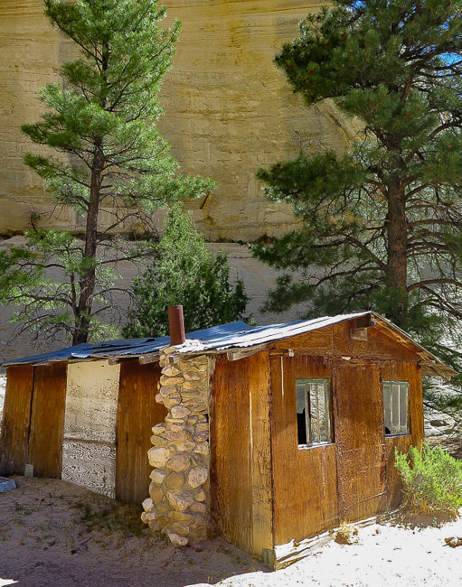
LeFevre cabin in Park Wash - 4.5 miles from Lick Wash trailhead 
Picture
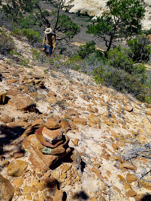
Cairn marking trail up debris fan.  Park Wash with trail below
Eroded bedding provides a staircase as you walk on more solid ground.  The trail gets steeper and more exposed.  Stunning views open up.  It appears that in some places sandstone has been chiseled to make the trail, probably by Jepson, the goat herder in 1927.  From the wash floor, the cliff walls looked impenetrable - now we were squeezing through the only known passage to the top.

Then suddenly we were taking the first steps into the relict, almost surreal world of No Mans Mesa with its relatively long and flat terrain, nothing but blue sky above.  Savoring each step, we took a break in pinyon pine shade near a ledge of burnt orange rock with hints of blue-grey - part of the Carmel Formation.   Many wildflowers were in seed.  There were no cheatgrass seeds getting stuck in my socks, only open bright sand weaving around healthy bunch grasses and small sand dunes sprouting native Arizona thistle.  On a short walk around the top, I found chert debitage, a white rock flake that shows evidence of stone tool-making.  Surprised by the presence of sand dunes, I then realized that in fact, Navajo Sandstone was created by deposition of wind-blown sand into large dunes (eolian environment).  It was originally red:  it was turned to a brilliant white color after reducing fluids dissolved the iron oxide from the grains of the deeply buried sandstone.
Picture
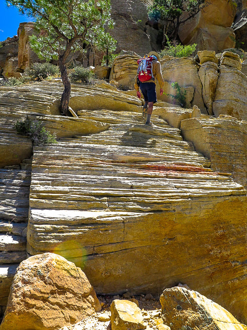
Trail shortly after crossing "bridge" between talus of debris fan and entrance into cliff rocks
Picture
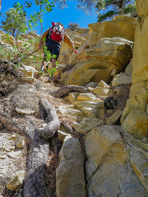
Nearing top through break in cliff to No Mans Mesa
Picture
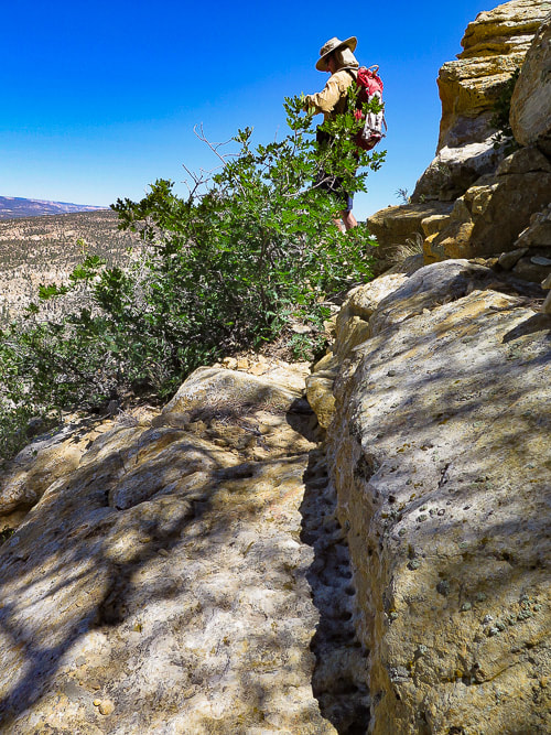
Trail appears to be chiseled into the rock at a few places
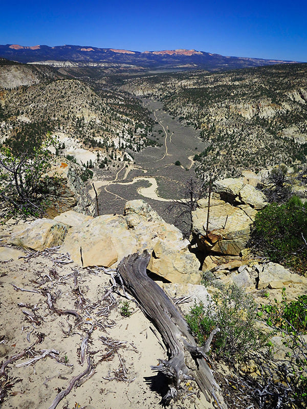
Picture
Finally at the top!
​View from top of No Mans Mesa of Park Wash and Pink Cliffs
For the Phytocurious
According to the study A Comparison of a near-relict site  and a grazed site in a pinyon-juniper community in the Grand Staircase National Monument, Utah,​ no non-native species were found on the study plots on No Mans Mesa.  This study compares vegetation species cover and richness, cryptobiotic crust cover and soil on  No Mans Mesa and Deer Spring Point, ~ 2 km southwest of No Mans Mesa.  Deer Spring Point is accessed by a road branching from Skutumpah Road and is grazed in the summer by domestic livestock.  Characteristics for these two study sites are similar:  same geology, elevation, soil, aspect and plant community type. 

Major findings comparing plant communities in the grazed site and the non-grazed, near-relict site:
  • Well-developed cryptobiotic crust cover was 60% less on Deer Spring Point than on No Mans Mesa.
  • Significantly more shrub cover on Deer Spring Point compared to No Mans Mesa, however, No Mans Mesa had more shrub diversity.
  • Consistently greater total vegetation cover and greater native vegetation cover was found on      Deer Spring Point compared to No Mans Mesa.
  • No difference in grass cover, but Muttongrass and Needle-and-Thread grass have twice as much cover on No Mans Mesa as on Deer Spring Point:   composition was different.
  • Non-native species were not abundant at either grazed or relict site.
  • Researchers did not find considerably more invasive species on the grazed site.
In our short exploration at the top, I was aware of just about every step on that isolated, ecologically "pure"  mesa elevated above lands that held invasive plants in this remote wilderness.   I felt I was taking steps about 200 years back in time before invasive species were introduced.

Reluctantly, I walked out of that beautiful land and committing to memory what this place looks like. We found our steep entrance and hiked down past the rusty mangled fence that Jepson must have used to keep his goats on the mesa.  Still not a cloud in the sky on this mid-June day.  White wash and trails curved their way through the dark sagebrush flat 800 feet below us.  This time, as we neared the lower section of   the debris fan, we veered north and found a less rocky and more sandy descent to the valley floor.  

By this time we were hiking in full blazing sun - it was getting pretty darn hot.  Pausing to rest under any shade we could find, we bypassed side canyons that would have to wait until next time.  At last we reached the cooler narrows of Lick Wash and shed our sweat-soaked shirts for awhile.

I wish I were in the shade of those sandstone walls, sliding my hands over the ancient and eroded beds, hearing the crunch of the purple-hued trail, and smelling the ponderosa pines.  We will be back here, but time keeps ticking.  A recently retired friend, talking about his planned adventures, said to me, "I don't know if I have enough money, but I sure as hell don't have enough time!"
How true.
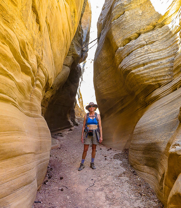
Picture
Lick Wash narrows
Picture
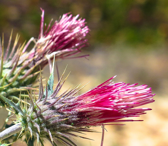
Native Arizona thistle
Picture
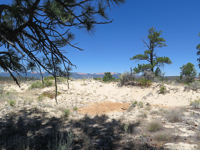
Sand dune!
Northern No Mans Mesa

Picture
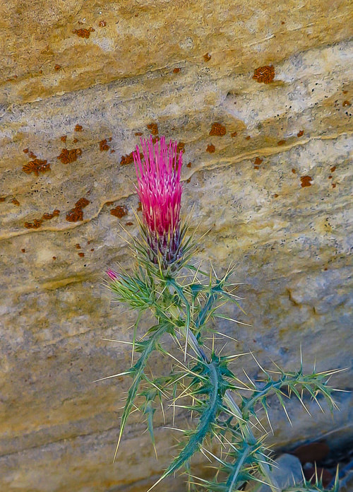
Arizona thistle (Cirsium arizonicum) against Navajo Sandstone
No Mans Mesa
Picture
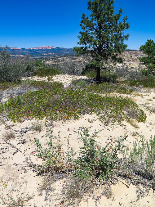
Loamy sand of No Mans Mesa
Picture
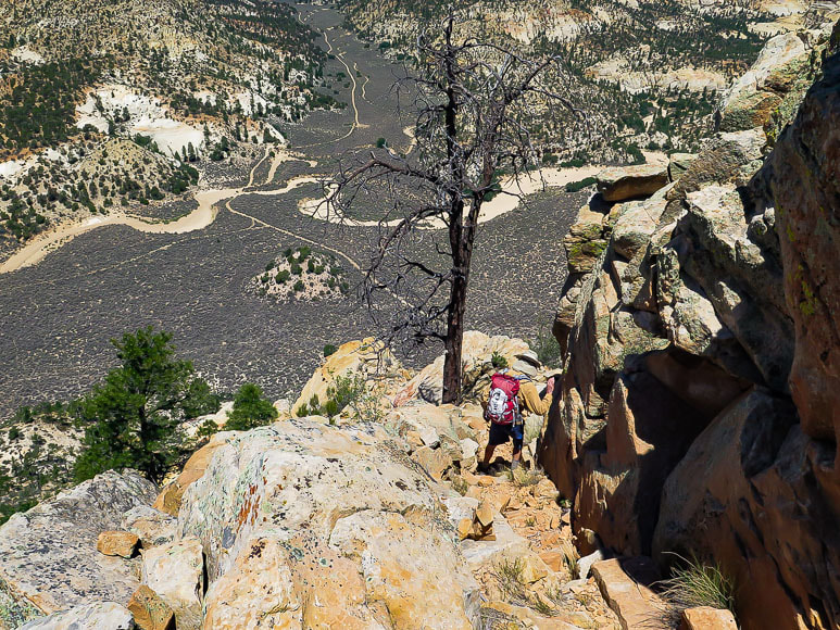
Making our way down - a few loose rocks
Picture
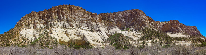
North tip of No Mans Mesa 
Ascend left side (northernmost point)
Picture
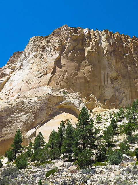
Navajo Sandstone cliffs of Calf Pasture Point
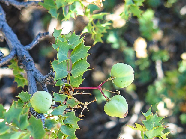
Picture
References:

Atkison, Ron. Hiking Grand Staircase-Escalante and the Glen Canyon Region.  1998.  Falcon Publishing. pp 288-292.
​
Gregory, Herbert E.  1951. The Geology and Geography of the Paunsaugunt Region Utah.  Geological Survey Professional Paper 226.  United States Government Printing Office.  

Guenther, D., Stohlgren, Thomas J., Evangelista, P.  2003.  A Comparison of a near-relict site  and a grazed site in a pinyon-juniper community in the Grand Staircase National Monument, Utah,​  In book:  The Colorado Plateau:  cultural, biological and physical research.  The University of Arizona Press, pp. 153-162.

Mason, Lamar R.,  Andrews, Horace M., Carley, James A., Haacke, E. Dwain.  1967.  Vegetation and Soils of No Man's Mesa Relict Area, Utah.  Journal of Range Management 20:  45-49.

7 Comments

    Categories

    All
    Arizona Hikes
    California Desert Hiking
    Idaho Summits
    Nevada Hikes
    Snowshoe Hikes
    Southern Utah Hikes/Bikes

    Complete list of Hikes/Bikes on HOME page
    Picture
    Sue and Fred
    Picture

    About this blog

    Exploration documentaries          –  "explorumentaries"  list trip stats and highlights of each hike or bike ride, often with some interesting history or geology.  Years ago, I wrote these for friends and family to let them know what my husband, Fred and I were up to on weekends, and also to showcase the incredible land of the west.  

    To Subscribe to Explorumentary adventure blog and receive new posts by email:

    submit
    Picture
    Happy Spring!
    Picture

    About the Author
    Sue Birnbaum

    A  trip to Jumbo Rocks Campground in Joshua Tree National Monument 38 years ago sparked my passion for hiking, exploring, and learning about desert ecosystems.  For the past 25 years, my husband Fred and I have explored the American West together; we love this land and I hope to inspire you to get out and explore through my photographs and trip descriptions.
    In 1992, Ray Wilson and I conceived the first Cactus to Clouds hike which climbs over 10,000 feet in one day to the summit of Mt. San Jacinto near Palm Springs, California.
    CACTUS TO CLOUDS HIKE 
    READ MORE
    ABOUT SUE

    Archives

    February 2023
    January 2023
    December 2022
    November 2022
    October 2022
    September 2022
    August 2022
    July 2022
    June 2022
    May 2022
    April 2022
    February 2022
    January 2022
    December 2021
    November 2021
    October 2021
    August 2021
    July 2021
    May 2021
    March 2021
    February 2021
    January 2021
    November 2020
    October 2020
    August 2020
    July 2020
    June 2020
    April 2020
    March 2020
    February 2020
    January 2020
    November 2019
    October 2019
    September 2019
    August 2019
    July 2019
    June 2019
    May 2019
    April 2019
    February 2019
    December 2018
    November 2018
    October 2018
    September 2018
    July 2018
    June 2018
    May 2018
    April 2018
    March 2018
    February 2018
    January 2018
    December 2017
    November 2017
    October 2017
    September 2017
    August 2017
    July 2017
    June 2017
    April 2017
    February 2017
    November 2013
    August 2013
    July 2013

    Some of my favorite websites:
    Awkward Botany
    ​citizen botany for the phytocurious

    Bird and Hike

    ​"Intended to encourage people to visit, learn about, and fall in love with the desert."
    ​

    Draw and Shoot
    Beautiful Photography

    Earthline: The American West
    Debra "writes to extol our beloved Earth." Detailed hike info, excellently written.
    ​

    Geologypics.com
    Geology and Geologic Time through Photographs

    Glenn Suokko
    Vermont artist's paintings "inspired by a place based on the land .... drawn to painting the representation and abstraction of nature."

    In the Company of Plants and Rocks
    ​A natural history blog about botany, plant ecology, and geology.

    Nature's Depths

    Walking through nature with John Palka, a neuroscientist who loves plants and ponders big questions

    Rangewriter - What Comes Next?
    ​With excellent writing, Linda tells the story of her unique mother's life including WWII era; with beautiful photographs.

    SeekingLost - Hiking and Backpacking Adventures.

    Stav Is Lost- Unconventional, out-of-the way hikes in the American West.


    Uprooted Magnolia
    ​Leah Yetter's beautiful "photo journal on life, love, and the spirit of Wyoming."
HOME

Cactus to Clouds Hike
More Quotes
HIKES BY STATE

Idaho Hikes
Utah Hikes/Bikes
​Arizona Hikes
​California Desert Hikes
​Wyoming Hikes
​Nevada Hikes

BLOGS

Adventure Blog
Women and the Land
GEAR REVIEWS
FIT AFTER 50
Fred Birnbaum
Dave Brasuell
Bus' Little Black Book
​Mike Carlson
​Ray Wilson
​Marcia Bondy
Bryan Krouse
​Maria Keezer
​Tim Clemens
​Doug Traubel
​Brian Holgate
​
Becky Borczon Blake
​Jennifer Cera and
​Sue Birnbaum

​Vance Powell
​Boise Cross Fit Masters Ladies
​Vickie Kearney

GALLERY

Desert Plants
Nature
Earth + Sky
Urban
Water
Patriot 
​Orchids
Boise
​
  ABOUT
    Contact

​
© 2017 - 2023 by Sue Birnbaum.  Photos on this website are the sole property of Sue Birnbaum unless otherwise indicated.  Please receive permission before publishing my trip reports and photos.
I try my best to be accurate with my hike descriptions; please research your adventures, always bring a map and compass and know how to read them, be prepared!  All of these hikes can be dangerous; hike at your own risk.  ALWAYS carry the Ten Essentials with you on hikes. 
​Please feel free to contact me with comments or questions, or if you see any errors that need attention.
Thank-you for stopping by!


EXPLORUMENTARY.com
  • Home
    • Cactus to Clouds Hike
    • More Quotes
    • Ann Zwinger Quotes
    • Mary Oliver Poems
  • Hikes by State
    • Idaho
    • Southern Utah
    • Arizona
    • California Desert
    • Nevada
    • Wyoming
  • BLOGS
    • Adventure Blog
    • Women and the Land
  • GALLERY
    • DESERT PLANTS >
      • Beavertail cactus
      • Brittlebush
      • Christmas Cactus
      • Arizona Barrel Cactus
      • Parry's penstemon
      • Agave
      • Arizona Rainbow Hedgehog
      • Claret Cup Hedgehog
      • Desert Agave
      • Palmer's Penstemon
      • Silver Cholla
      • Cristate Saguaro
      • Indian Paintbrush
      • Ocotillo
      • Santa Rita Prickly Pear
      • Spiny Cliffbrake
      • California Barrel Cactus
      • Engelmann Prickly Pear
      • Velvet Mesquite
      • Joshua Tree
      • Buckhorn Cholla
      • Hedgehog Cactus
      • Fishhook cactus
      • Thompson's Woolly Locoweed
    • NATURE
    • BOISE
    • EARTH + SKY
    • URBAN
    • WATER
    • PATRIOT
    • ORCHIDS
  • Fit After 50
    • Brian Holgate
    • Fred Birnbaum
    • Dave Brasuell
    • Bus' Little Black Book
    • Mike Carlson
    • Ray Wilson
    • Bryan Krouse
    • Vickie Kearney
    • Maria Keezer
    • DOUG TRAUBEL
    • Boise Cross Fit Masters Ladies
    • Tim Clemens
    • Marcia Bondy
    • Becky Borczon Blake >
      • Becky B Downtown
    • Jennifer Cera and Sue Birnbaum
    • Dave Brasuell
    • Vance Powell
  • About
    • CONTACT