EXPLORUMENTARY
  • Home
    • Cactus to Clouds Hike
    • Grand Canyon Rim to Rim - Hikes and Training
    • More Quotes
    • Ann Zwinger Quotes
    • Mary Oliver Poems
  • Hikes by State
    • Southern Utah
    • Idaho
    • Arizona
    • California Desert
    • Nevada
    • Wyoming and New Hampshire
  • Petroglyphs and Pictographs
  • BLOG
    • Adventure Blog
  • GALLERY
    • DESERT PLANTS >
      • Beavertail cactus
      • Brittlebush
      • Christmas Cactus
      • Arizona Barrel Cactus
      • Parry's penstemon
      • Agave
      • Arizona Rainbow Hedgehog
      • Claret Cup Hedgehog
      • Desert Agave
      • Palmer's Penstemon
      • Silver Cholla
      • Cristate Saguaro
      • Indian Paintbrush
      • Ocotillo
      • Santa Rita Prickly Pear
      • Spiny Cliffbrake
      • California Barrel Cactus
      • Engelmann Prickly Pear
      • Velvet Mesquite
      • Joshua Tree
      • Buckhorn Cholla
      • Hedgehog Cactus
      • Fishhook cactus
      • Thompson's Woolly Locoweed
      • Desert Five Spot
    • NATURE
    • BOISE
    • EARTH + SKY
    • URBAN
    • WATER
    • PATRIOT
    • ORCHIDS
  • Gear Reviews
  • Fit After 50
    • Brian Holgate
    • Fred Birnbaum
    • Dave Brasuell
    • Bus' Little Black Book
    • Mike Carlson
    • Ray Wilson
    • Bryan Krouse
    • Vickie Kearney
    • Maria Keezer
    • DOUG TRAUBEL
    • Boise Cross Fit Masters Ladies
    • Tim Clemens
    • Marcia Bondy
    • Becky Borczon Blake
    • Jennifer Cera and Sue Birnbaum
    • Dave Brasuell
    • Vance Powell
  • Contact

Lucky Peak Hike - Winter Ascent

3/19/2018

5 Comments

 
Snowshoe climb to Lucky Peak from Boise River Wilderness Management Area after a March snowstorm.
Related:  Four "Grand Slam Peaks" in Boise National Forest -
Cervidae Peak
Mt. Heinen:  Grand Slam Peaks Completed!
Kepros Mountain Hike
​
Lucky Peak:  The Ridge Less Traveled
Picture
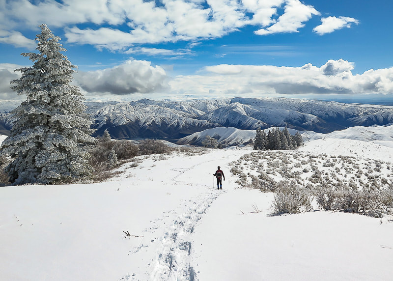
Trekking down from summit of Lucky Peak on southeast ridge
​Boise National Forest on horizon

Trip Stats
​
Overview:  This southeast approach to Lucky Peak (AKA Shaw Mountain) begins at the Boise River WMA following a dirt road that travels northwest along creek with burned vegetation from the Mile Marker 14 Fire July 2016.  It has less usage and more trees than the Homestead Trail approach from the southwest.  It passes an intersection to a road leading to Adelmann Mine, then climbs ridge to the summit.  Elk herds and deer often present.  Spectacular views of Treasure Valley and Boise National Forest close to Boise.  Side trip to Adelmann Mine with historic buildings not far from main road.
Difficulty:  moderate with no snow; moderate - strenuous with snow.  Route-finding skills needed if going off road and onto ridge.
Elevation gain:  Boise River Wilderness Management Area (trailhead) at 3,624':  Lucky Peak elevation 5,904' = ~ 2,280 feet.
Lucky Peak Coordinates:  43°36'18.82"N, 116°03'39.98"W.  Boise River Wilderness Management Area Coordinates:  43°34'26.7"N,  116°1'18.62"W
Map:  USGS Lucky Peak quad, 7.5-min series
Distance:  7 miles out and back.
Directions to trailhead:  Boise River WMA is on the west side of ID-21, 6.8 miles from E. Warm Springs Rd. and ID-21 intersection east of Boise.  It is a left hand turn to a small parking area with a gate just after Highland Valley Summit if you are heading north.
Geology:  Granite of Idaho Batholith, Cretaceous age 117 - 62 million years ago.
History:  Adelmann Mine's primary mineral was gold.​
Our Hike
A good friend commented, after reading my last post on Cervidae Peak, that Fred and I were "lucky" to have Lucky Peak as a training mountain.  We've hiked it many times during the 18 years that we have lived in Boise.  When we hike "the front side" of Lucky via Homestead Trail, the elevation gain is 3,000 feet and we always try to improve our time.   

​This time we snowshoed what we call the "back side" after a late winter snowstorm.  Snow depths varied from a few inches at the trailhead to ~ 12 inches at the summit.  A steady breeze from the northwest provided a good headwind for most of the climb.  The visibility at the summit was 300 yards, and hard rime ice created by heavy fog coated fir branches and last season's blue-bunch wheatgrass.  Fred and I took turns breaking trail through untracked snow.  On our way down, the clouds broke revealing a spectacular winter scene with views of the Boise National Forest to the northeast, Lucky Peak Lake to the southeast, and the Owyhee Mountain range to the south.  The contrast between the flat, dark Treasure Valley under shifting clouds and the bright white snow of mountains stretching to the horizon was of jaw-dropping beauty, the kind that makes you stop in your tracks.  Idaho is an incredible place!
Picture
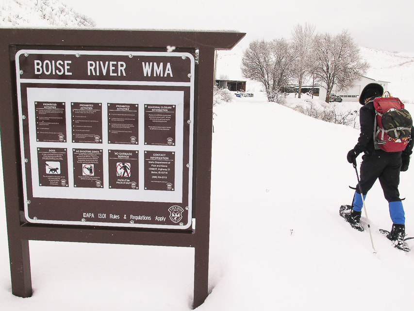
Boise River Wildlife Management Area sign at trailhead at ID Highway 21
Picture
Fred at start of ridge climb,  2 miles from trailhead, after intersection with trail to Adelmann Mine.
Picture
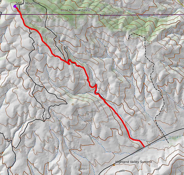
GPS tracks from WMA Headquarters trailhead on ID Hwy 21 to Lucky Peak (AKA Shaw Mountain)
​Follow road for 2 miles, then onto ridge to summit.
Picture
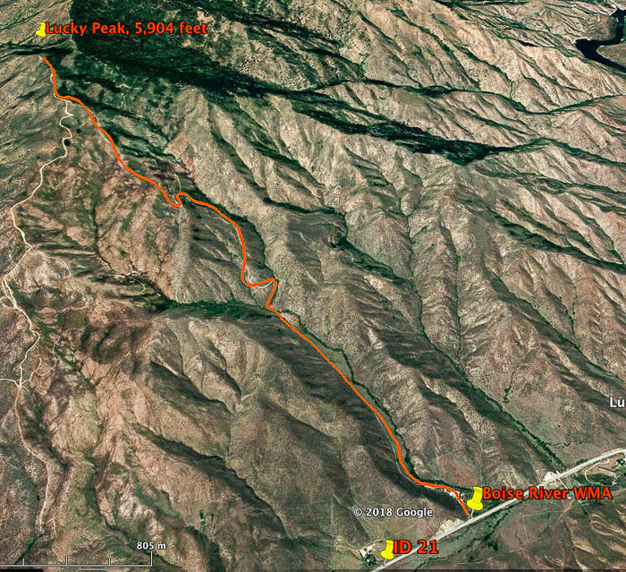
Our route to Lucky Peak (AKA Shaw Mountain) from Boise River WMA on ID Highway 21.  This route intersects with Route E. Shaw Mountain Road near the summit (on left).  Total hiking distance ~ 3.5 miles to summit with 2,280 feet of elevation gain.
This trail begins at the Boise River WMA buildings, following an often-muddy road in a northwest direction, with the tree line of Lucky Peak coming into view in about  .5 miles.  It crosses a creek, then begins a steep climb for 1 mile to the intersection of the road that leads to the abandoned buildings of Adelmann mine.  At this intersection, take the road to the left for a short climb to a ridge overlooking the valley to the south.  The road continues to the northwest and can be followed to the summit; it's here that we get off the road and take the more direct ridge route, beginning at two log stumps and a "No Motor Vehicles" sign.  We gain the ridge where the snow is wind-blown and not as deep and follow it towards the tree line on the right.  Toward the top, there is an intersection with E. Shaw Mountain Road, marked by a wooden birdhouse.  Our route continues on this road to an outhouse with the radio towers of Lucky Peak in view, then a short steep climb to the top.
Picture
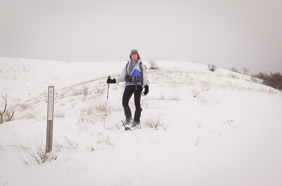
Point at which we leave the road to climb to ridge:  this is on a saddle separating Adelmann Mine to the north and Black Hornet Mine to the south
Picture
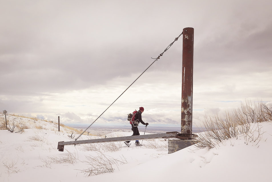
Mine apparatus (?) or gate (?) at ridge between Black Hornet Mine and Adelmann Mine, shortly after intersection of road to Adelmann Mine.  This marks the point on our route where we get off the road and climb Lucky Peak's southeast ridge 
Picture
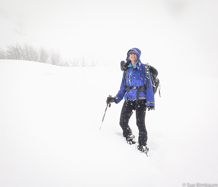
 Lucky Peak hike February 2019
Picture
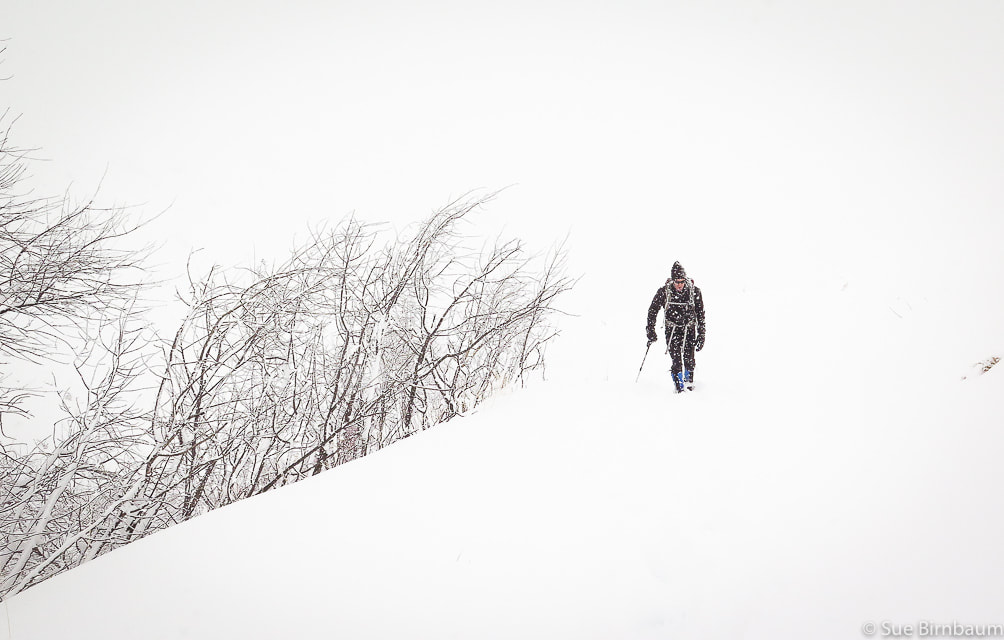
Lucky Peak hike during snowstorm - February 2019
Picture
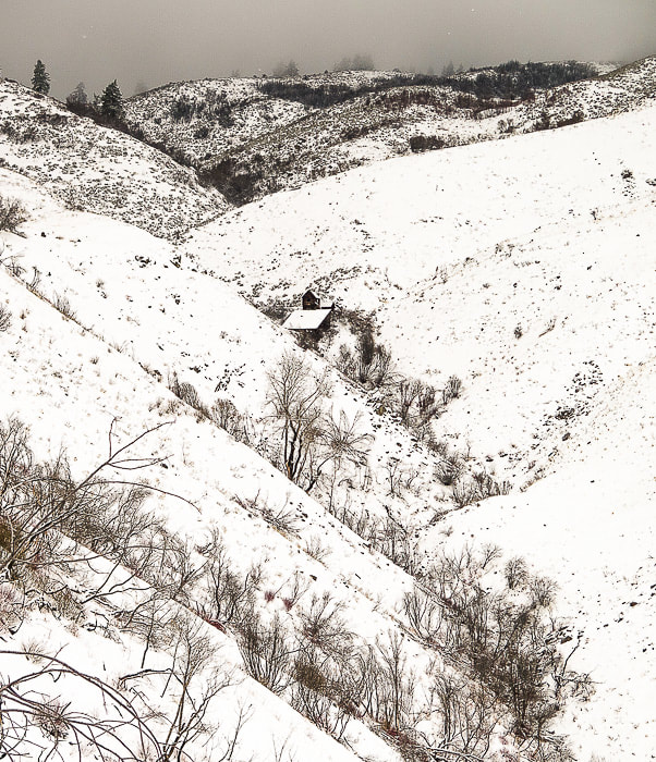
Building at Adelmann Mine
Picture
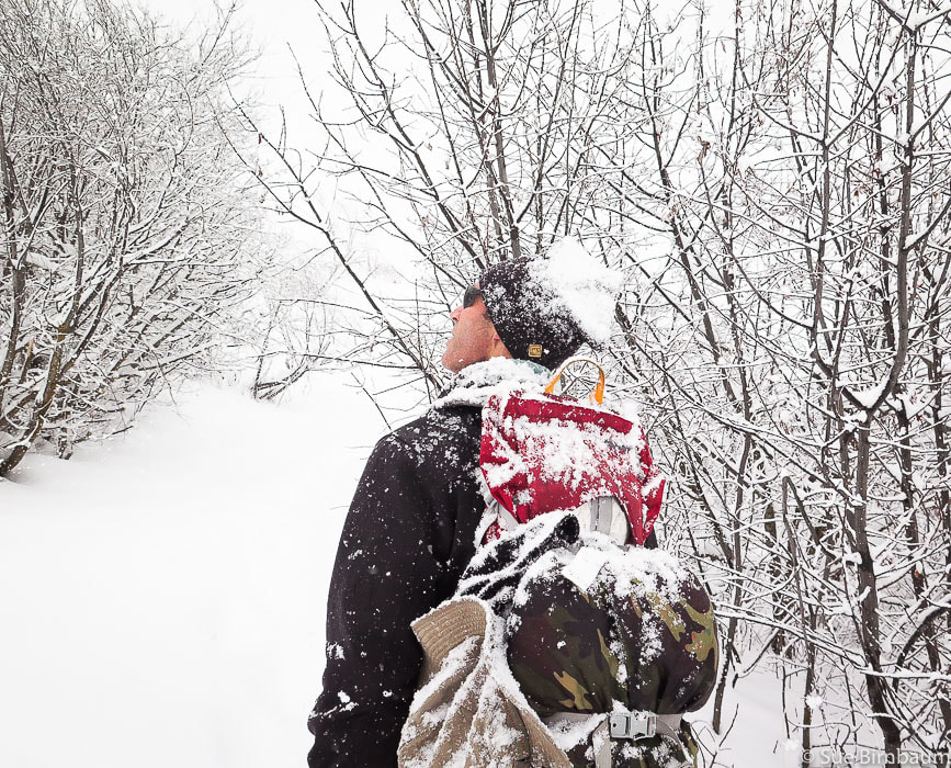
At intersection with road that leads to Adelmann Mine 
Picture
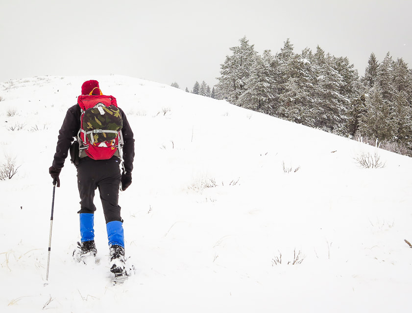
Hike up ridge toward Lucky Peak with trees to the right
Picture
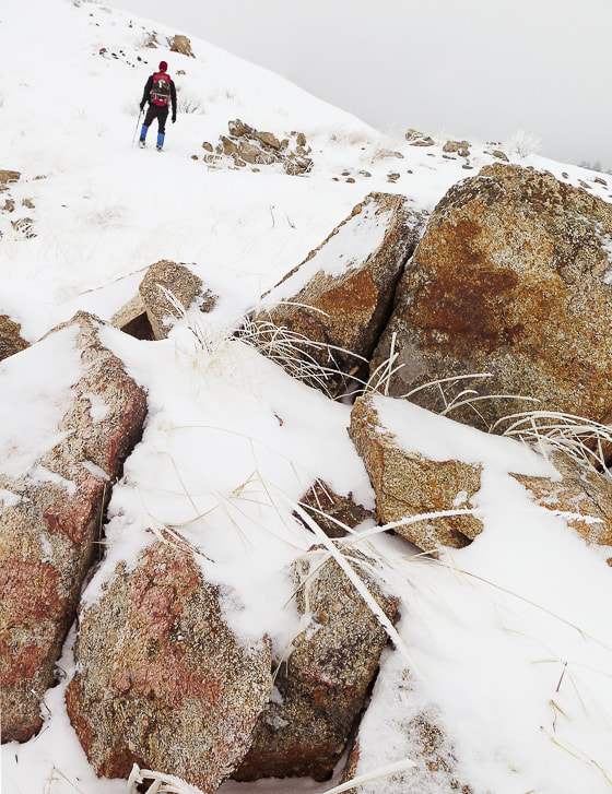
Granite of the Idaho Batholith
Hard rime ice had accumulated on the windward side of everything enveloped in the fog at the top.  We cleared a place in the snow, sat and ate lunch until we cooled down from the climb.  As we hiked down, the clouds thinned, illuminating trees, grasses and shrubs in a golden light, and a little further down we found ourselves in bright white fresh snow, walking toward the dark blue and white peaks of the Boise National Forest.  Since Lucky Peak is the highest point for miles around, it gives you the feeling that you are walking above almost everything else.
Picture
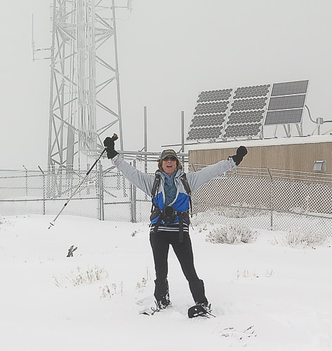
Radio Towers on summit of Lucky Peak - 5,904 feet
Picture
Picture
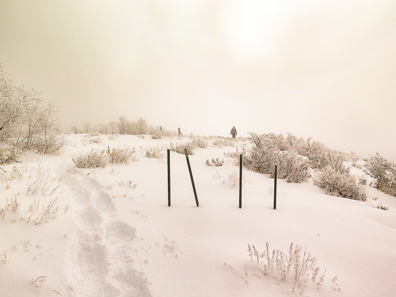
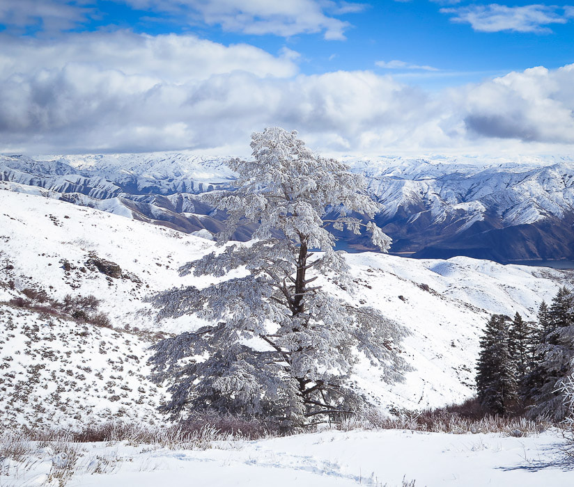
Douglas Fir with hard rime ice at higher elevations on Lucky Peak, looking northeast to Boise National Forest.
Picture
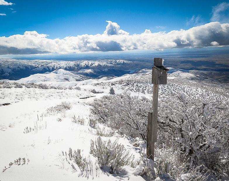
At intersection of our route and Route E. Shaw Mountain Road - follow this road to the summit of Lucky Peak
Picture
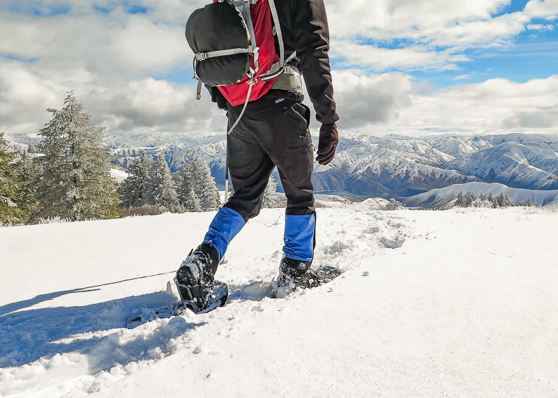
Great views of Boise National Forest and Lucky Peak Lake on the way down
Picture
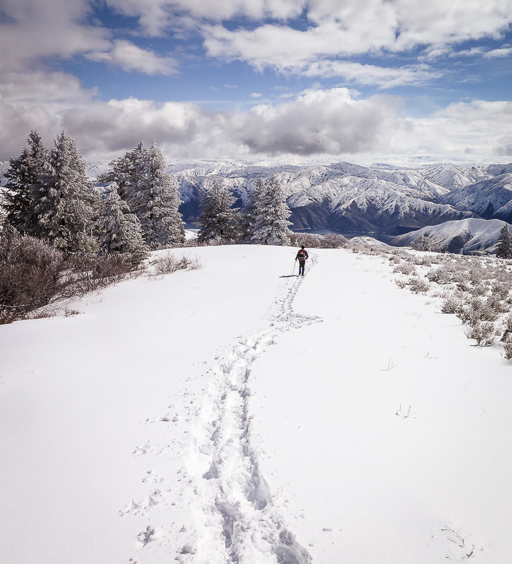
Clouds clearing on the way down- walking toward Lucky Peak Lake and Boise National Forest
Picture
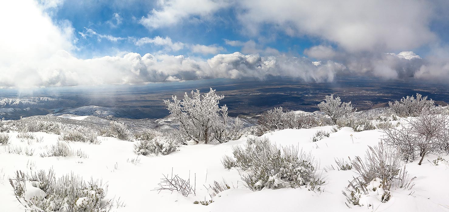
Antelope bitterbrush overlooking the Treasure Valley including Boise, Idaho.
Picture
Picture
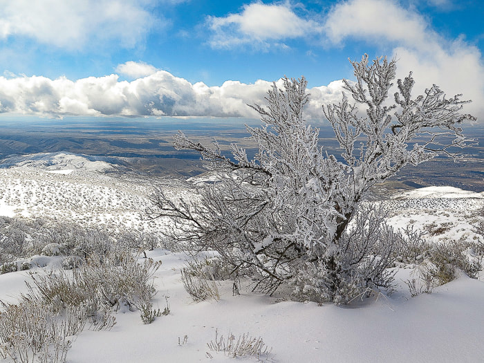
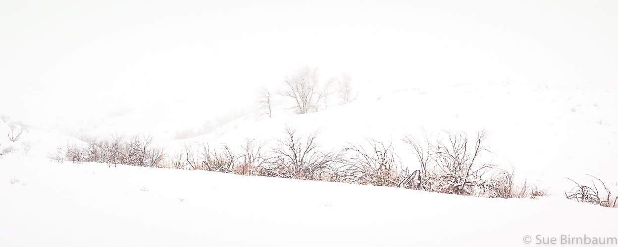
There's lots of advantages to snowshoeing vs. hiking with no snow:  vegetation is not damaged, you sharpen navigational and preparation skills, and best of all, quiet and solitude.  We went up into the clouds facing a steady headwind and came down in sun and breaking clouds with warmer temperatures.   We are lucky in Boise to have the opportunity to experience great snowshoeing treks.
5 Comments
Uncle Jim
3/28/2018 05:28:48 am

Great trek; awesome pictures!!!

Reply
Sue link
3/28/2018 06:43:57 pm

Thanks Uncle Jim!!! While you guys were enjoying the warm weather in Houston, we were in the snow in Boise! Looking forward to "the summer of love"

Reply
Sevenius link
10/31/2023 10:50:08 am

This wass great to read

Reply
Alexa Blyth link
8/1/2024 03:12:36 am

Amazing article, Thanks for this wonderful information.

Reply
Sue link
8/1/2024 07:00:50 am

Alexa, thanks for reading and commenting! I look back on our Idaho snowshoeing adventures and miss them - it's really awesome to get out there on the snowshoes. We live in southern Utah now so it takes more effort to find snow adventures!

Reply


Leave a Reply.

    Categories

    All
    Arizona Hikes
    California Desert Hiking
    Idaho Summits
    Nevada Hikes
    Petroglyphspictographs
    Snowshoe Hikes
    Southern Utah Hikesbikes

    To Subscribe to Explorumentary adventure blog and receive new posts by email:

    submit
    Picture
    Sue and Fred
    Picture
    Happy Winter!
    Picture

    About this blog

    Exploration documentaries          –  "explorumentaries"  list trip stats and highlights of each hike or bike ride, often with some interesting history or geology.  Years ago, I wrote these for friends and family to let them know what my husband, Fred and I were up to on weekends, and also to showcase the incredible land of the west.  
    Picture
    Picture

    About the Author
    ​
    Sue Birnbaum

    A  trip to Jumbo Rocks Campground in Joshua Tree National Monument 40 years ago sparked my passion for hiking, exploring, and learning about desert ecosystems.  I met my husband Fred on Mt. San Jacinto.  We've explored the American West together; we love this land and I hope to inspire you to get out and explore through my photographs and trip descriptions.
    In 1992, Ray Wilson and I conceived the first Cactus to Clouds hike which climbs over 10,000 feet in one day to the summit of Mt. San Jacinto near Palm Springs, California.
    CACTUS TO CLOUDS HIKE 
    READ MORE
    ABOUT SUE
    Some hiking
    websites I enjoy:

    Beyond my Couch

    Bird and Hike

    ​"Intended to encourage people to visit, learn about, and fall in love with the desert."

    Daring Dayhikes
    "Interesting places you can visit with a daypack."  Terrific Tucson and other desert hikes and East Coast, too.


    Earthline: The American West
    Debra "writes to extol our beloved Earth." Detailed hike info, excellently written.


    ​SeekingLost - Hiking and Backpacking Adventures.

    surgent.net - Scott Surgent's site, since 2002 describing lots of hikes in the southwest, especially Arizona, and other states.


    Stav Is Lost- Unconventional, out-of-the way hikes in the American West.
    Other Websites
    ​Awkward Botany
    ​amateur botany for the phytocurious.

    Draw and Shoot
    Beautiful Photography


    ​Glenn Suokko
    Vermont artist's paintings "inspired by a place based on the land .... drawn to painting the representation and abstraction of nature."


    ​Rangewriter - What Comes Next?
    ​Linda's excellent writing brings to life her interesting adventures, "curiosities and thoughts", post-retirement.

    MishMoments:  Joy of Photography
    this website is "
    about capturing that special moment in life’s journey and making the most of the time we have."
    ​

    Nature's Depths
    Walking through nature with John Palka, a neuroscientist who loves plants and ponders big questions.

    In the Company of Plants and Rocks
    ​A natural history blog about botany, plant ecology, and geology.


    Geologypics.com
    Geology and Geologic Time through Photographs.
    ​

    Archives

    November 2025
    October 2025
    July 2025
    April 2025
    March 2025
    January 2025
    December 2024
    November 2024
    October 2024
    September 2024
    August 2024
    July 2024
    June 2024
    May 2024
    April 2024
    March 2024
    January 2024
    December 2023
    November 2023
    October 2023
    September 2023
    August 2023
    July 2023
    June 2023
    May 2023
    April 2023
    February 2023
    January 2023
    December 2022
    November 2022
    October 2022
    September 2022
    August 2022
    July 2022
    June 2022
    May 2022
    April 2022
    February 2022
    January 2022
    December 2021
    November 2021
    October 2021
    August 2021
    July 2021
    May 2021
    March 2021
    February 2021
    January 2021
    November 2020
    October 2020
    August 2020
    July 2020
    June 2020
    April 2020
    March 2020
    February 2020
    January 2020
    November 2019
    October 2019
    September 2019
    August 2019
    July 2019
    June 2019
    May 2019
    April 2019
    February 2019
    December 2018
    November 2018
    October 2018
    September 2018
    July 2018
    June 2018
    May 2018
    April 2018
    March 2018
    February 2018
    January 2018
    December 2017
    November 2017
    October 2017
    September 2017
    August 2017
    July 2017
    June 2017
    April 2017
    February 2017
    November 2013
    August 2013
    July 2013

HOME

Cactus to Clouds Hike
More Quotes
​
Mary Oliver Poems
Ann Zwinger Quotes
HIKES BY STATE

Idaho Hikes
Utah Hikes/Bikes
​Arizona Hikes
​California Desert Hikes
​Wyoming Hikes
​Nevada Hikes

BLOG

Adventure Blog
Women and the Land
GEAR REVIEWS
FIT AFTER 50

GALLERY

Desert Plants
Nature
Earth + Sky
Urban
Water
Patriot 
​Orchids
Boise
​
ABOUT
 Contact

​
© 2017 - 2026 by Sue Birnbaum.  Photos on this website are the sole property of Sue Birnbaum unless otherwise indicated.  Please receive permission before publishing my trip reports and photos.
I try my best to be accurate with my hike descriptions; please research your adventures, always bring a map and compass and know how to read them, be prepared!  All of these hikes can be dangerous; hike at your own risk.  ALWAYS carry the Ten Essentials with you on hikes. 
​Please feel free to contact me with comments or questions, or if you see any errors that need attention.
Thank-you for stopping by!


EXPLORUMENTARY.com
  • Home
    • Cactus to Clouds Hike
    • Grand Canyon Rim to Rim - Hikes and Training
    • More Quotes
    • Ann Zwinger Quotes
    • Mary Oliver Poems
  • Hikes by State
    • Southern Utah
    • Idaho
    • Arizona
    • California Desert
    • Nevada
    • Wyoming and New Hampshire
  • Petroglyphs and Pictographs
  • BLOG
    • Adventure Blog
  • GALLERY
    • DESERT PLANTS >
      • Beavertail cactus
      • Brittlebush
      • Christmas Cactus
      • Arizona Barrel Cactus
      • Parry's penstemon
      • Agave
      • Arizona Rainbow Hedgehog
      • Claret Cup Hedgehog
      • Desert Agave
      • Palmer's Penstemon
      • Silver Cholla
      • Cristate Saguaro
      • Indian Paintbrush
      • Ocotillo
      • Santa Rita Prickly Pear
      • Spiny Cliffbrake
      • California Barrel Cactus
      • Engelmann Prickly Pear
      • Velvet Mesquite
      • Joshua Tree
      • Buckhorn Cholla
      • Hedgehog Cactus
      • Fishhook cactus
      • Thompson's Woolly Locoweed
      • Desert Five Spot
    • NATURE
    • BOISE
    • EARTH + SKY
    • URBAN
    • WATER
    • PATRIOT
    • ORCHIDS
  • Gear Reviews
  • Fit After 50
    • Brian Holgate
    • Fred Birnbaum
    • Dave Brasuell
    • Bus' Little Black Book
    • Mike Carlson
    • Ray Wilson
    • Bryan Krouse
    • Vickie Kearney
    • Maria Keezer
    • DOUG TRAUBEL
    • Boise Cross Fit Masters Ladies
    • Tim Clemens
    • Marcia Bondy
    • Becky Borczon Blake
    • Jennifer Cera and Sue Birnbaum
    • Dave Brasuell
    • Vance Powell
  • Contact