EXPLORUMENTARY
  • Home
    • Cactus to Clouds Hike
    • More Quotes
    • Ann Zwinger Quotes
    • Mary Oliver Poems
  • Hikes by State
    • Idaho
    • Southern Utah
    • Arizona
    • California Desert
    • Nevada
    • Wyoming
  • BLOGS
    • Adventure Blog
    • Women and the Land
  • GALLERY
    • DESERT PLANTS >
      • Beavertail cactus
      • Brittlebush
      • Christmas Cactus
      • Arizona Barrel Cactus
      • Parry's penstemon
      • Agave
      • Arizona Rainbow Hedgehog
      • Claret Cup Hedgehog
      • Desert Agave
      • Palmer's Penstemon
      • Silver Cholla
      • Cristate Saguaro
      • Indian Paintbrush
      • Ocotillo
      • Santa Rita Prickly Pear
      • Spiny Cliffbrake
      • California Barrel Cactus
      • Engelmann Prickly Pear
      • Velvet Mesquite
      • Joshua Tree
      • Buckhorn Cholla
      • Hedgehog Cactus
      • Fishhook cactus
      • Thompson's Woolly Locoweed
    • NATURE
    • BOISE
    • EARTH + SKY
    • URBAN
    • WATER
    • PATRIOT
    • ORCHIDS
  • Fit After 50
    • Brian Holgate
    • Fred Birnbaum
    • Dave Brasuell
    • Bus' Little Black Book
    • Mike Carlson
    • Ray Wilson
    • Bryan Krouse
    • Vickie Kearney
    • Maria Keezer
    • DOUG TRAUBEL
    • Boise Cross Fit Masters Ladies
    • Tim Clemens
    • Marcia Bondy
    • Becky Borczon Blake >
      • Becky B Downtown
    • Jennifer Cera and Sue Birnbaum
    • Dave Brasuell
    • Vance Powell
  • About
    • CONTACT

Cervidae Peak - Southeast Ridge Route

3/16/2018

2 Comments

 
Short and steep hike along ridge overlooking Lucky Peak Reservoir with great views, Boise National Forest
Related Posts: 
Four "Grand Slam Peaks" in Boise National Forest -
Mt. Heinen - Grand Slam Peaks Completed!
Lucky Peak - Winter Ascent
​Kepros Mountain Hike
Trip Stats
Overview:  Trail to Cervidae Peak is only 17 miles east of Boise and traverses along the ridge between Mores Creek to the west and Lucky Peak Reservoir to the south.  Vegetation includes bunch grasses, rabbitbrush, antelope bitterbrush and sagebrush.  Spectacular views of Spring Shores Marina and Lucky Peak Reservoir to the south, Lucky Peak to the west, and Shafer Butte to the northwest.
Distance:   2.3 miles to summit (according to my GPS)
Elevation Gain:   Trailhead at 3,120 feet,  summit at 4,987 feet = 1,867 feet.  Add to this ~ 120 feet of elevation due to loss/gain on ridge - Total elevation gain ~ 2,000 feet in 2.3 miles.
Coordinates:   Cervidae Peak:  43°36'50.66"N, 115°58'26.75"W.
Driving Directions:  Drive ID-21 north from Boise past Lucky Peak Dam, over Highland Summit.  Cross over the High Bridge that crosses Mores Creek with vertical basalt cliffs.  Almost immediately after the bridge, turn right on FS-269 that leads to Spring Shores Marina and Atlanta.  About 2 miles past the marina, park on the right in a large pull-out.  Trailhead at large gate across road.
Trail:  After passing the gate, the trail starts to the left of a short gravel road, where it contours the bottom of the southeast ridge heading east and then turns to the northwest, gaining the ridge.  The trail is well-worn and heads straight up the southeast ridge to the summit.
Picture
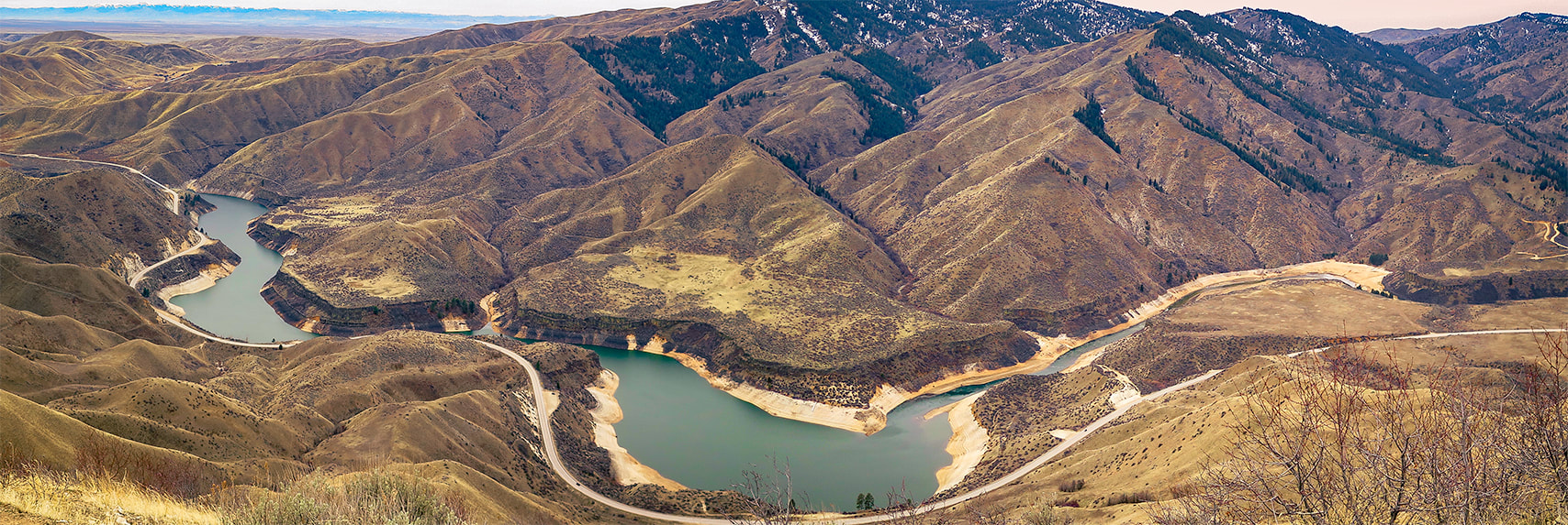
View of Lucky Peak Lake and Lucky Peak from Cervidae Mountain trail
Picture
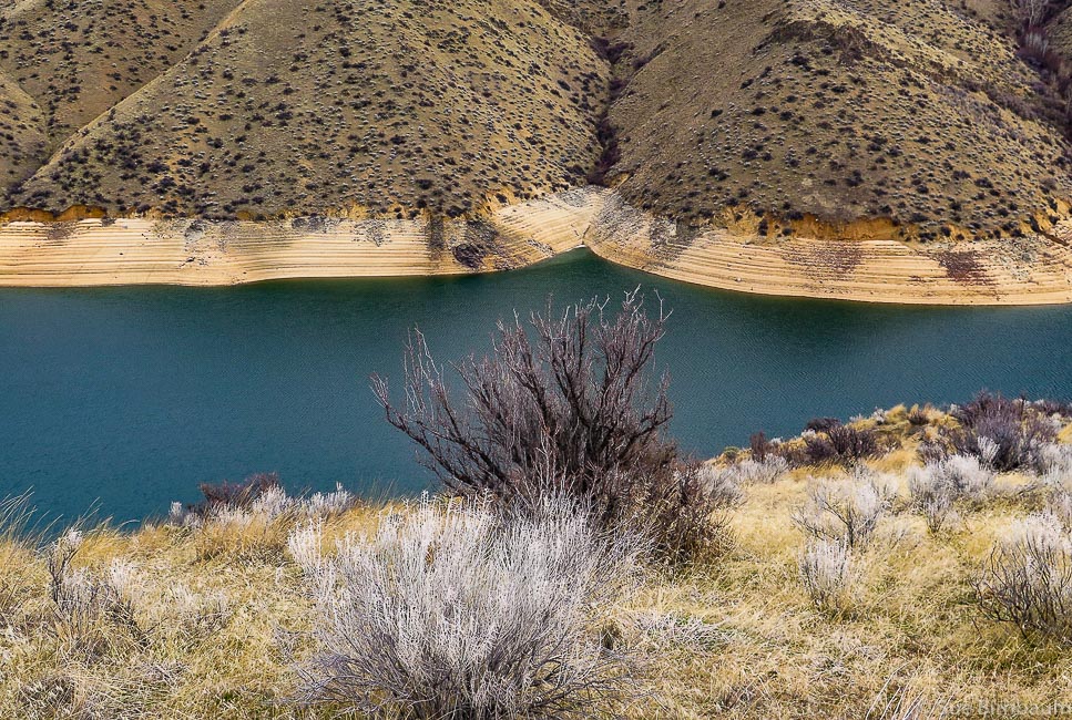
View from east side of ridge
Cervidae Peak is one of the 4  "Grand Slam Peaks" that Tom Lopez, author of Idaho:  A Climbing Guide describes.  The other 3 peaks are Mt. Heinen, Kepros Mountain, and Lucky Peak, all close to Boise.  As Tom Lopez does, Fred and I use Cervidae and Lucky Peak to train for our summer  mountain summit hikes.  We discovered Cervidae when we wanted to add variety to our usual Lucky Peak training.

Cervidae Peak is great for a lot of reasons:  it's close to Boise, the trail is steep with no switchbacks once you get on the ridge, so you can get a decent work-out in a short amount of time and see some awesome views.  It's a great opportunity to get a good view of Lucky Peak Reservoir and identify landmarks at the 360 degree view at the top.  The family Cervidae is a scientific classification that includes deer, elk, moose and reindeer.
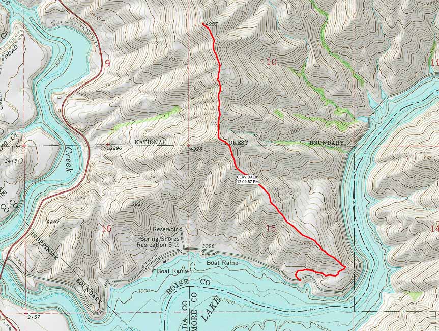
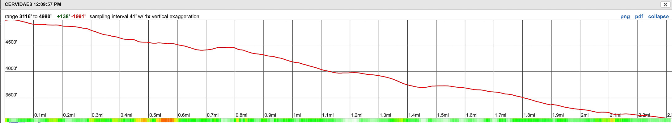
Picture
Picture
Southeast Ridge route and elevation profile -  Cervidae Peak (4,987 feet)
Lucky Peak Lake at bottom of photo - High Bridge  over Mores Creek (ID-21) lower left
Distance = 2.3 miles one way with elevation gain of ~ 2,000 feet
Picture
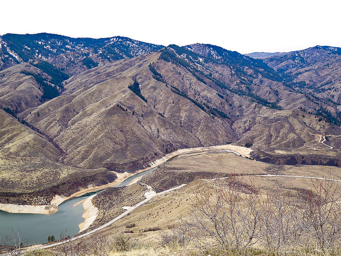
Lucky Peak Reservoir
Lucky Peak (high forested peak on left)
Picture
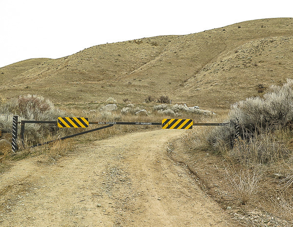
Gate at start of Cervidae Peak hike - follow gravel road to right, in about 200 yards, the trail starts  on the left side of the road
History
The Lucky Peak Dam was built in 1955 to be included in the system of flood control and use of irrigation water from the Boise River.  This was done mainly as an assurance to water users of the Boise River system that their supply of water would be protected and the Arrowrock Dam and Anderson Ranch Dam above the Lucky Peak Dam could be drained down during flood control measures.  It was a way of adding water capacity; building Anderson Ranch and Lucky Peak reservoirs were moves toward multiple-use reservoirs.

The Reclamation Service, a U.S. Federal government agency started construction of Arrowrock Dam, a few miles further upstream from Cervidae's trailhead on the Boise River for the purpose of storing water for irrigation in the early 1900's.  Arrowrock Dam was dedicated in 1915 by Reclamation; it was the tallest dam in the world at that time and 4,000 people gathered to witness the dedication.  The report, History of Boise River Reservoir Operations gives a great history and overview of management of the Boise River.

Geology
Large granitic intrusions during Cretaceous time (144 - 65 mya) that formed the ​Idaho Batholith  make up the bedrock of Cervidae and the upper Boise River drainage.  Cervidae Peak can also be summited from its west ridge; it's near this access where basalt dikes that cut through the granitic basement are seen along the east side of ID 21 a few miles past the high bridge that spans vertical basalt cliffs.  
Picture
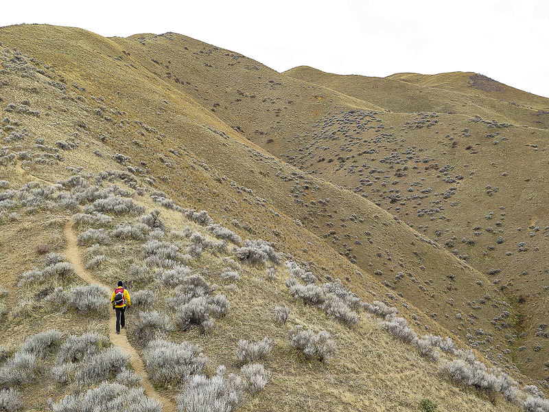
No switchbacks here - Cervidae is on right side of ridgeline
Picture
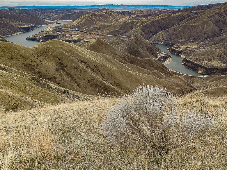
Native Grey Rabbitbrush and bunchgrass overlooking Lucky Peak Reservoir
Owhyee Mountains to the south on far horizon
Most of the trail is steep and it's about all that you can see in front of you at times,  but then you get to a rise on the ridge and see expansive views.  About 3/4 of the way up this trail, the trail from the west side of the ridge intersects.  This trail is accessed from Highway 21 and provides a more direct hike to the summit.  The trail loses some elevation near the summit only to regain it,  followed by less steep terrain toward the top.

We found a register at the summit pile of granite.  A steady, bitter cold breeze had made us cold despite having climbed almost 2,000 feet.  Surprisingly, the summit was calm but cold.  Looking toward the northeast, we tried to identify Mount Heinen, a climb on our spring bucket list.

We did this hike with 2 friends a couple of summers ago - in the afternoon!  Not the best time to do this hike - it was hot and there's no shade.  This is a good late winter/early spring hike.  
Picture
Picture
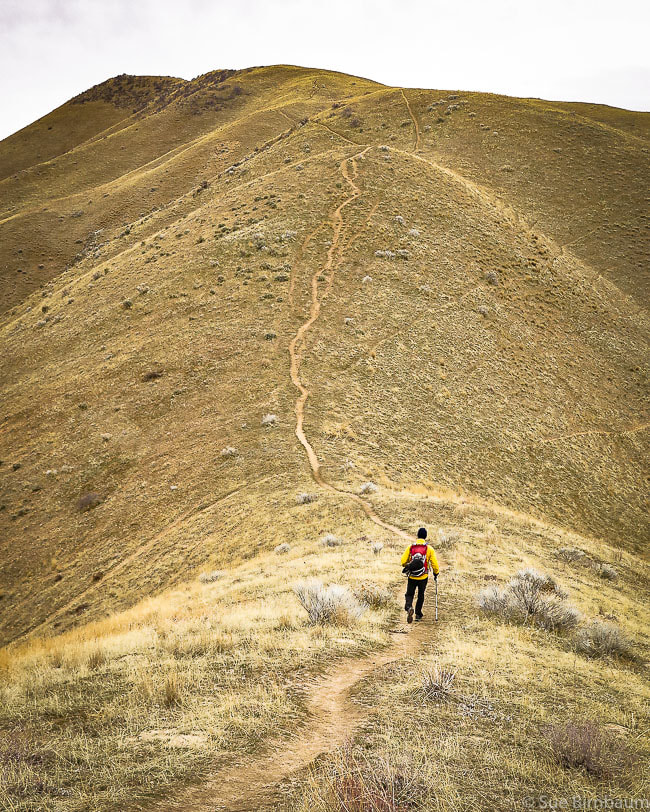
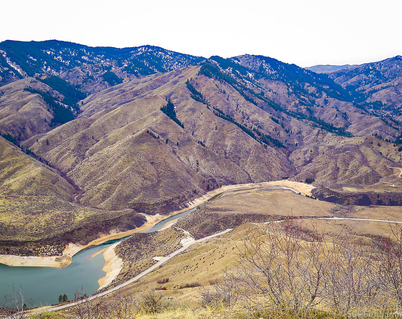
View of Lucky Peak (far left)  ~ 900 feet higher in elevation than Cervidae Peak
Lucky Peak elevation = 5,904 feet

Picture
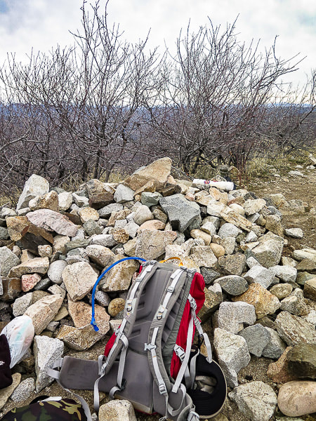
Cervidae Peak summit - 4,987 feet
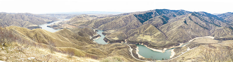
Picture
 References
Bliss, James D., and Phillip R. Moyle. 2001.  Assessment of the Sand and Gravel Resources of the Lower Boise River Valley Area, Idaho.  U.S. Dept. of the Interior - U.S. Geological Survey,  41 pages.

Idaho Batholith:  Idaho's Natural History Online from Idaho Museum of Natural History/Idaho State University.  Retrieved from:  http://imnh.isu.edu/digitalatlas/geo/bathlith/bathdex.htm.
​
Othberg, Kurt L. and Willis L. Burnham. 1990.  Geologic Map of the Lucky Peak Quadrangle,  Ada County, Idaho.  Idaho Geological Survey, University of Idaho, Moscow, ID,  13 pages.

Stevens, Jennifer. 2015.  History of Boise River Reservoir Operations, 1912-1995.  Stevens Historical Research Associates, 67 pages.
2 Comments
top essay writers link
12/1/2018 04:59:01 am

 I want to reach the Cervidae Peak someday. Well! I just started reaching mountains. It would definitely be a great experience for me if I will be given the chance to reach the said peak since it was said to be one of the hardest peaks to reach in the country. Hiking is one of the activities I started doing this year. So far, I enjoy the activity and I still no have plan on stopping for it! I also influenced my friends to do the same thing so that they can join me whenever they want.

Reply
Sue link
12/1/2018 08:57:23 am

That's awesome that you are influencing your friends! I hope you will get more and more hikes accomplished and let me know how you are doing! Cervidae is short but really steep and the views are worth it. Thanks for your comment and keep on exploring!

Reply


Leave a Reply.

    Categories

    All
    Arizona Hikes
    California Desert Hiking
    Idaho Summits
    Nevada Hikes
    Snowshoe Hikes
    Southern Utah Hikes/Bikes

    Complete list of Hikes/Bikes on HOME page
    Picture
    Sue and Fred
    Picture

    About this blog

    Exploration documentaries          –  "explorumentaries"  list trip stats and highlights of each hike or bike ride, often with some interesting history or geology.  Years ago, I wrote these for friends and family to let them know what my husband, Fred and I were up to on weekends, and also to showcase the incredible land of the west.  

    To Subscribe to Explorumentary adventure blog and receive new posts by email:

    submit
    Picture
    Happy Spring!
    Picture

    About the Author
    Sue Birnbaum

    A  trip to Jumbo Rocks Campground in Joshua Tree National Monument 38 years ago sparked my passion for hiking, exploring, and learning about desert ecosystems.  For the past 25 years, my husband Fred and I have explored the American West together; we love this land and I hope to inspire you to get out and explore through my photographs and trip descriptions.
    In 1992, Ray Wilson and I conceived the first Cactus to Clouds hike which climbs over 10,000 feet in one day to the summit of Mt. San Jacinto near Palm Springs, California.
    CACTUS TO CLOUDS HIKE 
    READ MORE
    ABOUT SUE

    Archives

    February 2023
    January 2023
    December 2022
    November 2022
    October 2022
    September 2022
    August 2022
    July 2022
    June 2022
    May 2022
    April 2022
    February 2022
    January 2022
    December 2021
    November 2021
    October 2021
    August 2021
    July 2021
    May 2021
    March 2021
    February 2021
    January 2021
    November 2020
    October 2020
    August 2020
    July 2020
    June 2020
    April 2020
    March 2020
    February 2020
    January 2020
    November 2019
    October 2019
    September 2019
    August 2019
    July 2019
    June 2019
    May 2019
    April 2019
    February 2019
    December 2018
    November 2018
    October 2018
    September 2018
    July 2018
    June 2018
    May 2018
    April 2018
    March 2018
    February 2018
    January 2018
    December 2017
    November 2017
    October 2017
    September 2017
    August 2017
    July 2017
    June 2017
    April 2017
    February 2017
    November 2013
    August 2013
    July 2013

    Some of my favorite websites:
    Awkward Botany
    ​citizen botany for the phytocurious

    Bird and Hike

    ​"Intended to encourage people to visit, learn about, and fall in love with the desert."
    ​

    Draw and Shoot
    Beautiful Photography

    Earthline: The American West
    Debra "writes to extol our beloved Earth." Detailed hike info, excellently written.
    ​

    Geologypics.com
    Geology and Geologic Time through Photographs

    Glenn Suokko
    Vermont artist's paintings "inspired by a place based on the land .... drawn to painting the representation and abstraction of nature."

    In the Company of Plants and Rocks
    ​A natural history blog about botany, plant ecology, and geology.

    Nature's Depths

    Walking through nature with John Palka, a neuroscientist who loves plants and ponders big questions

    Rangewriter - What Comes Next?
    ​With excellent writing, Linda tells the story of her unique mother's life including WWII era; with beautiful photographs.

    SeekingLost - Hiking and Backpacking Adventures.

    Stav Is Lost- Unconventional, out-of-the way hikes in the American West.


    Uprooted Magnolia
    ​Leah Yetter's beautiful "photo journal on life, love, and the spirit of Wyoming."
HOME

Cactus to Clouds Hike
More Quotes
HIKES BY STATE

Idaho Hikes
Utah Hikes/Bikes
​Arizona Hikes
​California Desert Hikes
​Wyoming Hikes
​Nevada Hikes

BLOGS

Adventure Blog
Women and the Land
GEAR REVIEWS
FIT AFTER 50
Fred Birnbaum
Dave Brasuell
Bus' Little Black Book
​Mike Carlson
​Ray Wilson
​Marcia Bondy
Bryan Krouse
​Maria Keezer
​Tim Clemens
​Doug Traubel
​Brian Holgate
​
Becky Borczon Blake
​Jennifer Cera and
​Sue Birnbaum

​Vance Powell
​Boise Cross Fit Masters Ladies
​Vickie Kearney

GALLERY

Desert Plants
Nature
Earth + Sky
Urban
Water
Patriot 
​Orchids
Boise
​
  ABOUT
    Contact

​
© 2017 - 2023 by Sue Birnbaum.  Photos on this website are the sole property of Sue Birnbaum unless otherwise indicated.  Please receive permission before publishing my trip reports and photos.
I try my best to be accurate with my hike descriptions; please research your adventures, always bring a map and compass and know how to read them, be prepared!  All of these hikes can be dangerous; hike at your own risk.  ALWAYS carry the Ten Essentials with you on hikes. 
​Please feel free to contact me with comments or questions, or if you see any errors that need attention.
Thank-you for stopping by!


EXPLORUMENTARY.com
  • Home
    • Cactus to Clouds Hike
    • More Quotes
    • Ann Zwinger Quotes
    • Mary Oliver Poems
  • Hikes by State
    • Idaho
    • Southern Utah
    • Arizona
    • California Desert
    • Nevada
    • Wyoming
  • BLOGS
    • Adventure Blog
    • Women and the Land
  • GALLERY
    • DESERT PLANTS >
      • Beavertail cactus
      • Brittlebush
      • Christmas Cactus
      • Arizona Barrel Cactus
      • Parry's penstemon
      • Agave
      • Arizona Rainbow Hedgehog
      • Claret Cup Hedgehog
      • Desert Agave
      • Palmer's Penstemon
      • Silver Cholla
      • Cristate Saguaro
      • Indian Paintbrush
      • Ocotillo
      • Santa Rita Prickly Pear
      • Spiny Cliffbrake
      • California Barrel Cactus
      • Engelmann Prickly Pear
      • Velvet Mesquite
      • Joshua Tree
      • Buckhorn Cholla
      • Hedgehog Cactus
      • Fishhook cactus
      • Thompson's Woolly Locoweed
    • NATURE
    • BOISE
    • EARTH + SKY
    • URBAN
    • WATER
    • PATRIOT
    • ORCHIDS
  • Fit After 50
    • Brian Holgate
    • Fred Birnbaum
    • Dave Brasuell
    • Bus' Little Black Book
    • Mike Carlson
    • Ray Wilson
    • Bryan Krouse
    • Vickie Kearney
    • Maria Keezer
    • DOUG TRAUBEL
    • Boise Cross Fit Masters Ladies
    • Tim Clemens
    • Marcia Bondy
    • Becky Borczon Blake >
      • Becky B Downtown
    • Jennifer Cera and Sue Birnbaum
    • Dave Brasuell
    • Vance Powell
  • About
    • CONTACT