EXPLORUMENTARY
  • Home
    • Cactus to Clouds Hike
    • More Quotes
    • Ann Zwinger Quotes
    • Mary Oliver Poems
  • Hikes by State
    • Southern Utah
    • Idaho
    • Arizona
    • California Desert
    • Nevada
    • Wyoming and New Hampshire
  • Petroglyphs and Pictographs
  • BLOG
    • Adventure Blog
  • GALLERY
    • DESERT PLANTS >
      • Beavertail cactus
      • Brittlebush
      • Christmas Cactus
      • Arizona Barrel Cactus
      • Parry's penstemon
      • Agave
      • Arizona Rainbow Hedgehog
      • Claret Cup Hedgehog
      • Desert Agave
      • Palmer's Penstemon
      • Silver Cholla
      • Cristate Saguaro
      • Indian Paintbrush
      • Ocotillo
      • Santa Rita Prickly Pear
      • Spiny Cliffbrake
      • California Barrel Cactus
      • Engelmann Prickly Pear
      • Velvet Mesquite
      • Joshua Tree
      • Buckhorn Cholla
      • Hedgehog Cactus
      • Fishhook cactus
      • Thompson's Woolly Locoweed
    • NATURE
    • BOISE
    • EARTH + SKY
    • URBAN
    • WATER
    • PATRIOT
    • ORCHIDS
  • Fit After 50
    • Brian Holgate
    • Fred Birnbaum
    • Dave Brasuell
    • Bus' Little Black Book
    • Mike Carlson
    • Ray Wilson
    • Bryan Krouse
    • Vickie Kearney
    • Maria Keezer
    • DOUG TRAUBEL
    • Boise Cross Fit Masters Ladies
    • Tim Clemens
    • Marcia Bondy
    • Becky Borczon Blake >
      • Becky B Downtown
    • Jennifer Cera and Sue Birnbaum
    • Dave Brasuell
    • Vance Powell
  • Contact

Bald Mountain via Station Creek - Garden Valley, Idaho

11/30/2019

2 Comments

 
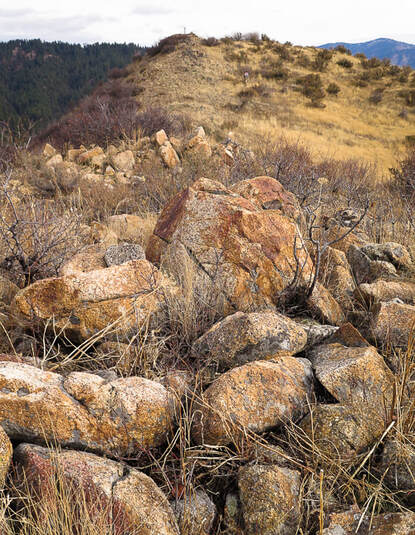
From doorstep to summit in just a few hours, this hike close to Boise offers a quiet Ponderosa pine forest, a good climb and great views of Boise National Forest.
Related:
​Jackson Peak Lookout, 8,124' - Boise NF
​
Wolf Mountain and Point 8,610  via Jennie Lake, Boise NF
Picture
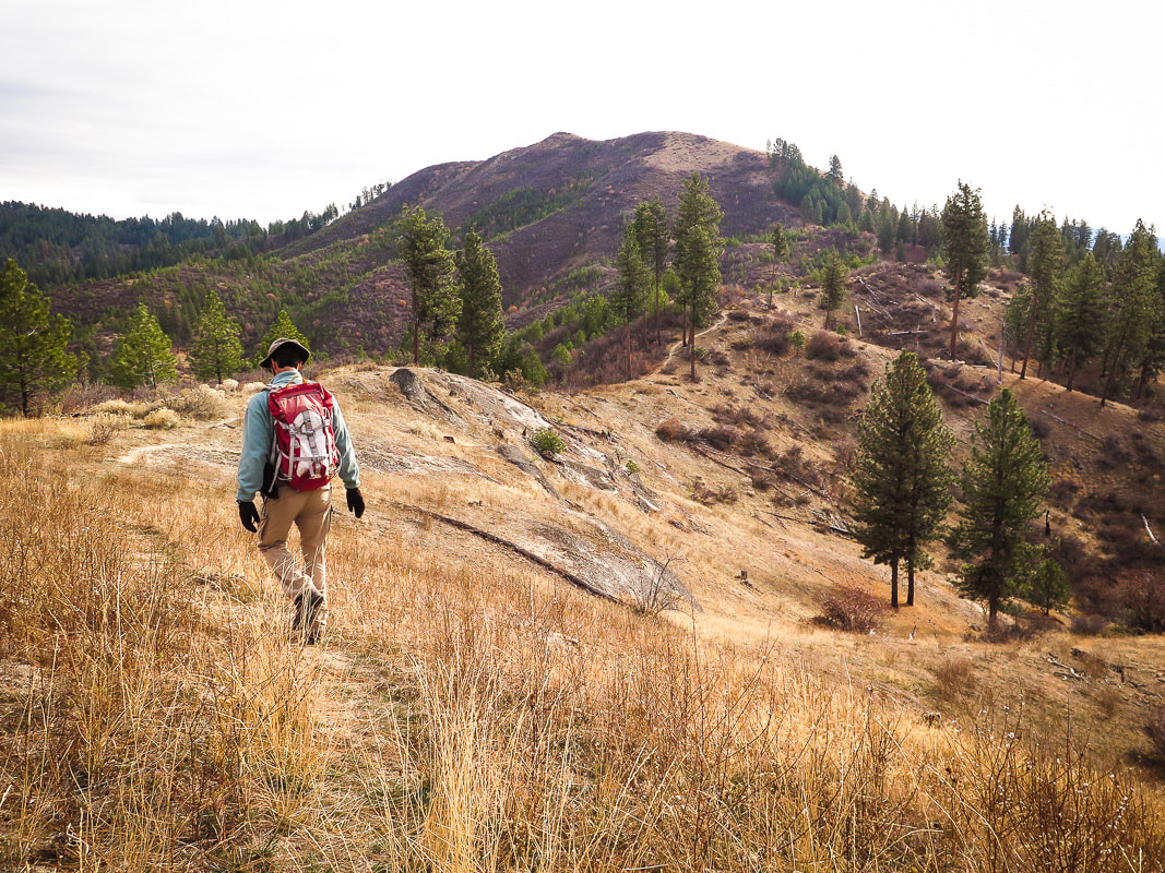
Final approach to Bald Mountain's (aka Poorman) summit; Little Anderson watershed to the left and drainage into Poorman Creek to the right.  Nice exposures of Idaho batholith granite.  Elevation - 5,134 feet.
Trip Stats:
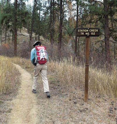
Location:  Southwest Salmon River Mountains in the Boise National Forest, with North Fork of the Payette River to the west and South Fork Payette River to the south.  Just over one hour's drive from Boise, near Garden Valley, Idaho.
Distance: 7.6 miles round-trip.
Elevation gain:  Trailhead = 3,190 feet, summit = 5,134 feet.  Total net gain = 2,500 feet.
Difficulty:  Moderate Class 1 single track trail.
Trail location:  Station Creek Trail #152.  Trailhead just across from Garden Valley Ranger Station on the Banks-Lowman Road, Hwy 17 (Wildlife Canyon Scenic Byway).
Permit:  None
Map:  Boise National Forest - U.S. Forest Service and USDA.  See our GPS tracks on topo map below.
Date Hiked:  November 16, 2019.
Alternate route:  2 loops below the summit - Stueby's Outdoor Journal.
Summit location:  44.0815   -1158890
Geology:  Atlanta Lobe of the Idaho Batholith;  granodiorite and two-mica granite - Cretaceous (85-67 Ma).
Boise National Forest - History and Culture.  USDA
​​Driving Directions​
Hiking Directions
Picture
Picture
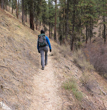
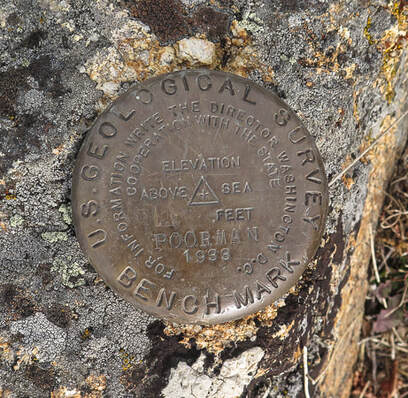
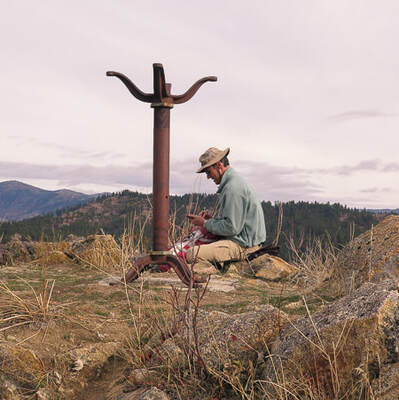
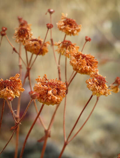
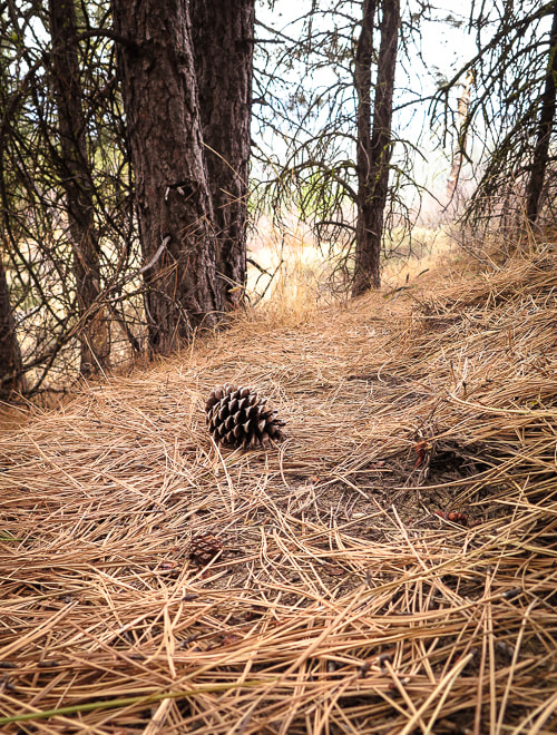
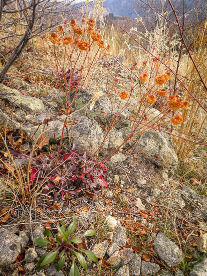
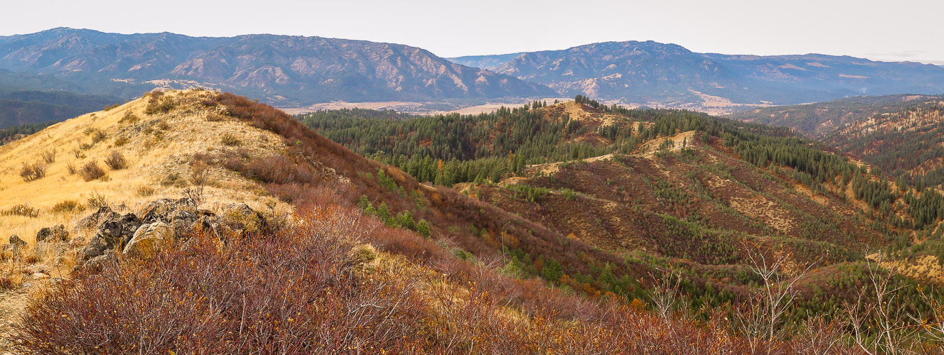
One of Idaho's greatest assets is the ability to find forest solitude in a short amount of time.  After an hour's drive north from Boise, we started our walk on the Station Creek Trail in the Boise National Forest's 2.5 million acres, weaving through a Ponderosa pine forest to a ridge with a view of Bald Mountain.  The summit feels grander than its relatively low elevation would suggest.   It stands high above Little Anderson Creek to the north, and Poorman Creek to the south, with views of snow-dusted Salmon River Mountains to the northeast.  Everything is good on this adventure - beautiful drive, challenging grade on a relatively short distance with great views.

"Poorman" is engraved on Bald Mountain's summit benchmark, a triangulation station established by the U.S. Geological Survey in 1933.   The History of the Boise National Forest - 1905-1976, an informative document, covers many subjects from the area's Native Americans, to the creation and administration of the Boise National Forest, its resources and its settlement.  The Sawtooth Forest Reserve was created in 1905 by President Theodore Roosevelt.  A combination of the west portion of this reserve and the 1.5-million acre Payette Forest Reserve created the Boise National Forest July 1, 1908.  Idaho is one of the top states that has a large percentage of publicly-owned lands - 62% of it under federal jurisdiction of BLM and Forest Service.  This does not include state-owned land.

The Payette River was named after Francois Payette, a French-Canadian Hudson Bay Company fur trapper who explored southwestern Idaho.  Bald Mountain is tucked in between the main waterways of North Fork and South Fork of Payette River.
Picture
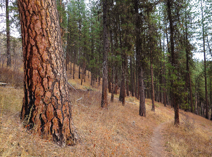
The stately Ponderosa pine is easy to recognize because of its orange-brown bark arranged in large vertical plates.  In the spring, the tree's sap produces a vanilla scent.  The needles are 5-10 inches long and grow in clusters of three.
Access the Station Creek trailhead just off the Banks-Lowman Highway, right across from Garden City Ranger Station and heliport, past Mile 12 and Boise National Forest sign.  The trail treks north as it follows Station Creek, crosses it at 0.8 miles, then climbs the ridge that separates Station Creek and Poorman Creek.  At mile 2.6, this ridge tops out at Point 4,772 with bare-topped Bald Mountain in full view.
Picture
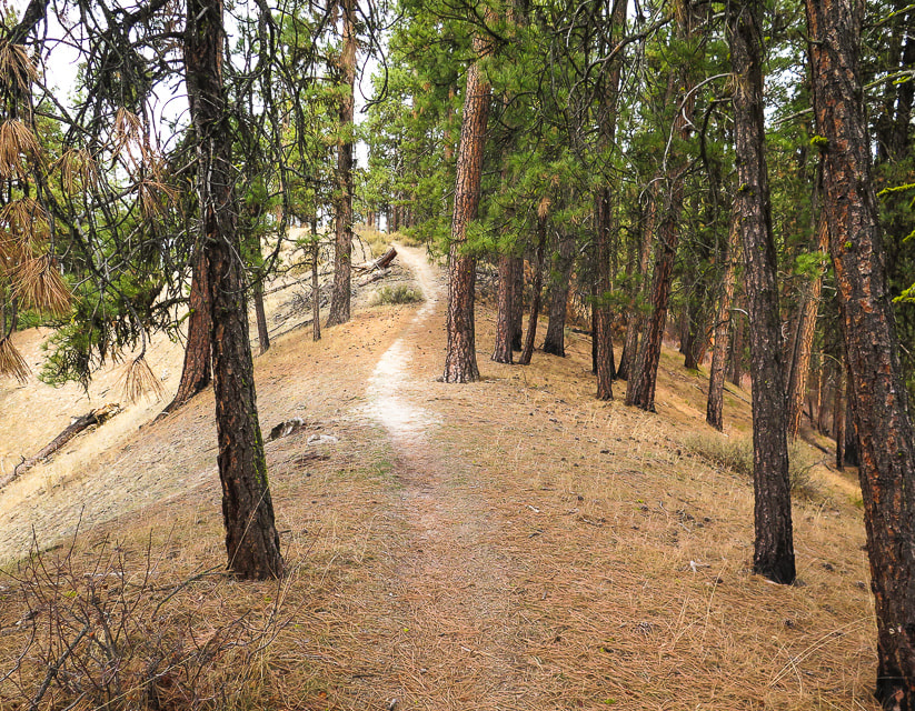
Single track over combination of pine needles and gravel on ridge between Station Creek and Poorman Creek leading to Point 4,772.
Picture
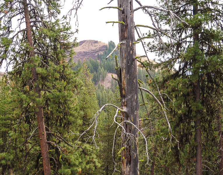
View of Bald Mountain from ridge
From point 4,772, hike 1.2 miles east/southeast to Bald Mountain's summit past some exposed granite outcrops.  The trail becomes less defined as it traverses across the top of the watershed for Little Anderson Creek, then through a tall shady stand of Ponderosa pines.  The trail then climbs the steep, open and grassy western slope to Bald Mountain's granite summit surrounded by the fall hues of red, yellow and orange senescent buckwheat and lomatium flowers.  

Bald Mountain stands above Garden Valley to the west and deep South Fork of the Payette River to the south and the snow-dusted  Salmon River Mountains to the north.  For a peak close to home, it feels and looks like wilderness - a quick nature fix.

An iron stand bolted into cement on the summit looks like it might have supported something, or is merely a marker.  I was unable to find information on this and the origin of the word "Poorman", although it could be in reference to previous mining activity.

Many Ponderosa pine trunks are blackened from the 18,000-acre West Anderson fire that occurred due to a lightning strike in August of 1986.  Four firefighters from New Mexico died when their truck tumbled down a dry creek bed near Crouch as they were driving from their fire camp.  Map of Boise National Forest fire history.

In the spring, this trail is bright with wildflowers, but autumn produces muted colors and textures, just as beautiful.  There are two loops that can be hiked instead of summiting Bald Mountain (Stueby's Outdoor Journal).  
Picture
Picture
Picture
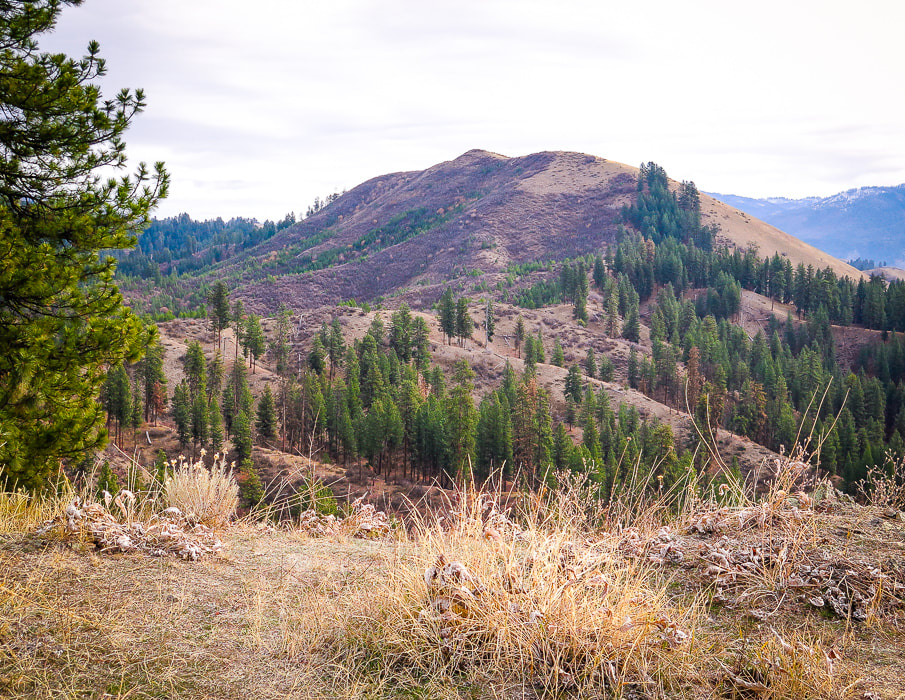
Poorman triangulation marker on Bald Mountain's summit placed in 1933.
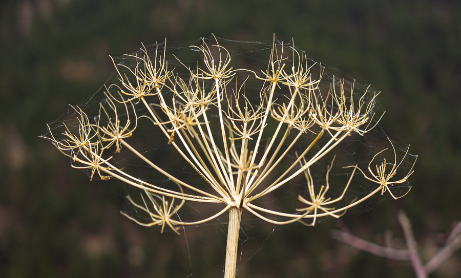
Picture
Granite of the Idaho batholith - Cretaceous
Summit with iron stand in distance

Picture
Eriogonum (Buckwheat)
Picture
Picture
Autumn lomatium
Picture
Picture
Picture
From the summit - view of Garden Valley to the west
Picture
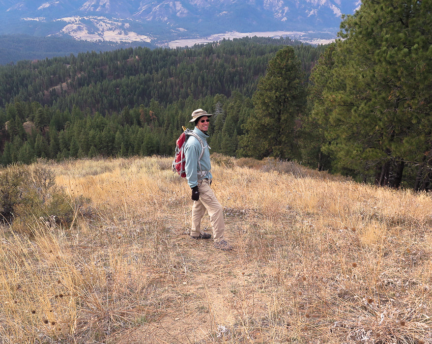
Descending just off summit - I Love Idaho!
Picture
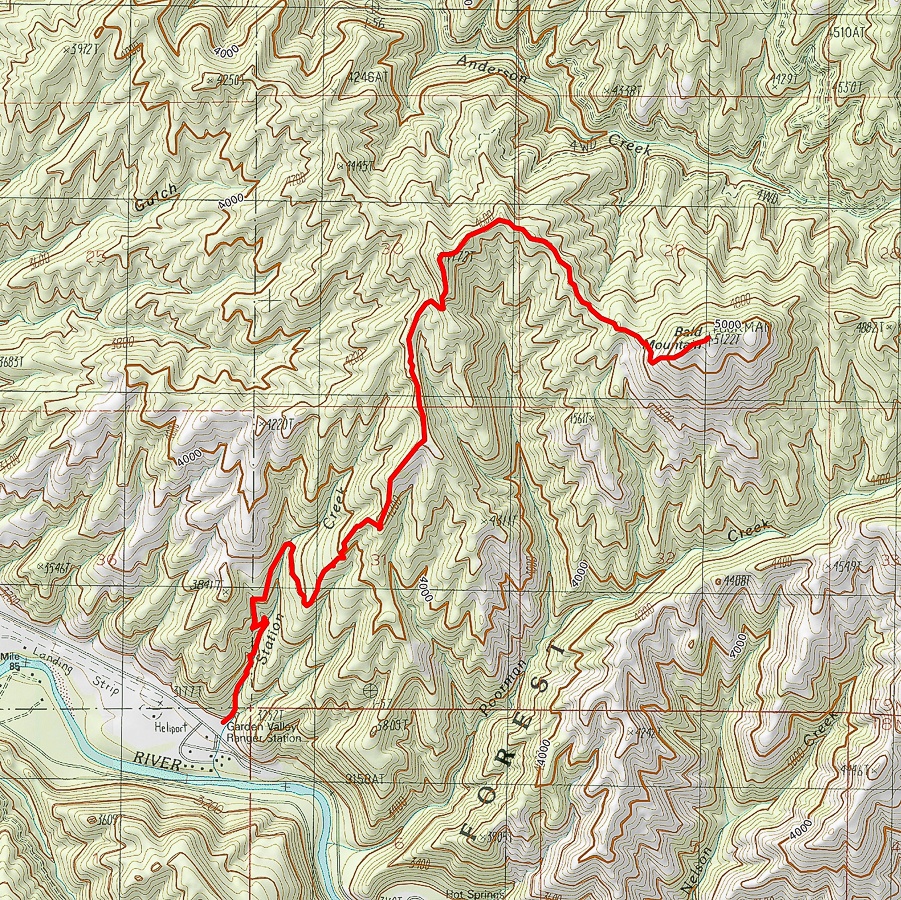
Our GPS tracks from Station Creek Trailhead to Bald Mountain Summit
click on map for larger image
References:
Boise National Forest Large Fire History, 1980-2018  (Map).  https://www.idahofireinfo.blm.gov › southwest › documents › maps › BOF...
​
Smith, E.M.  1986. History of the Boise National Forest, 1905-1976.  Idaho State Historical Society.
Our History.  Garden Valley Chamber of Commerce website.
Ponderosa pine.  US Forest Service.
2 Comments
Linda Paul link
12/5/2019 01:38:32 pm

I haven't been up there since the west side of Bald Mountain burned. Great photos, as always.

Reply
Sue link
12/5/2019 02:15:35 pm

Linda,
I really appreciate how your comments make me look deeper into the history of the land I'm writing about. I noticed pines burned long ago on the trail, and looked up the fire history of Boise National Forest and found that the West Anderson fire occurred on the west side of Bald Mountain area in 1986, and in fact, 4 firefighters from New Mexico died fighting that lightning-caused fire. I will add this info to the post. There is a memorial plaque in Danskin creek. Thanks for commenting!

Reply


Leave a Reply.

    Categories

    All
    Arizona Hikes
    California-desert-hiking
    California-desert-hiking
    Idaho Summits
    Nevada Hikes
    Petroglyphspictographs
    Snowshoe Hikes
    Southern Utah Hikesbikes

    To Subscribe to Explorumentary adventure blog and receive new posts by email:

    submit
    Picture
    Sue and Fred
    Picture

    About this blog

    Exploration documentaries          –  "explorumentaries"  list trip stats and highlights of each hike or bike ride, often with some interesting history or geology.  Years ago, I wrote these for friends and family to let them know what my husband, Fred and I were up to on weekends, and also to showcase the incredible land of the west.  
    Picture
    Happy Spring!
    Picture

    About the Author
    Sue Birnbaum

    A  trip to Jumbo Rocks Campground in Joshua Tree National Monument 40 years ago sparked my passion for hiking, exploring, and learning about desert ecosystems.  I met my husband Fred on Mt. San Jacinto.  We've explored the American West together; we love this land and I hope to inspire you to get out and explore through my photographs and trip descriptions.
    In 1992, Ray Wilson and I conceived the first Cactus to Clouds hike which climbs over 10,000 feet in one day to the summit of Mt. San Jacinto near Palm Springs, California.
    CACTUS TO CLOUDS HIKE 
    READ MORE
    ABOUT SUE
    Some of my favorite websites:
    ​

    ​Awkward Botany
    ​amateur botany for the phytocurious

    Bird and Hike

    ​"Intended to encourage people to visit, learn about, and fall in love with the desert."
    ​

    Draw and Shoot
    Beautiful Photography

    Daring Dayhikes
    "Interesting places you can visit with a daypack."  Terrific Tucson and other desert hikes and East Coast, too.


    Earthline: The American West
    Debra "writes to extol our beloved Earth." Detailed hike info, excellently written.
    ​

    Geologypics.com
    Geology and Geologic Time through Photographs

    Glenn Suokko
    Vermont artist's paintings "inspired by a place based on the land .... drawn to painting the representation and abstraction of nature."

    In the Company of Plants and Rocks
    ​A natural history blog about botany, plant ecology, and geology.


    MishMoments:  Joy of Photography
    this website is "
    about capturing that special moment in life’s journey and making the most of the time we have."

    Nature's Depths
    Walking through nature with John Palka, a neuroscientist who loves plants and ponders big questions.


    Rangewriter - What Comes Next?
    ​Linda's excellent writing brings to life her interesting adventures, "curiosities and thoughts", post-retirement.

    SeekingLost - Hiking and Backpacking Adventures.

    Stav Is Lost- Unconventional, out-of-the way hikes in the American West.


    Uprooted Magnolia
    ​Leah Yetter's beautiful "photo journal on life, love, and the spirit of Wyoming."

    Archives

    April 2025
    March 2025
    January 2025
    December 2024
    November 2024
    October 2024
    September 2024
    August 2024
    July 2024
    June 2024
    May 2024
    April 2024
    March 2024
    January 2024
    December 2023
    November 2023
    October 2023
    September 2023
    August 2023
    July 2023
    June 2023
    May 2023
    April 2023
    February 2023
    January 2023
    December 2022
    November 2022
    October 2022
    September 2022
    August 2022
    July 2022
    June 2022
    May 2022
    April 2022
    February 2022
    January 2022
    December 2021
    November 2021
    October 2021
    August 2021
    July 2021
    May 2021
    March 2021
    February 2021
    January 2021
    November 2020
    October 2020
    August 2020
    July 2020
    June 2020
    April 2020
    March 2020
    February 2020
    January 2020
    November 2019
    October 2019
    September 2019
    August 2019
    July 2019
    June 2019
    May 2019
    April 2019
    February 2019
    December 2018
    November 2018
    October 2018
    September 2018
    July 2018
    June 2018
    May 2018
    April 2018
    March 2018
    February 2018
    January 2018
    December 2017
    November 2017
    October 2017
    September 2017
    August 2017
    July 2017
    June 2017
    April 2017
    February 2017
    November 2013
    August 2013
    July 2013

HOME

Cactus to Clouds Hike
More Quotes
​
Mary Oliver Poems
Ann Zwinger Quotes
HIKES BY STATE

Idaho Hikes
Utah Hikes/Bikes
​Arizona Hikes
​California Desert Hikes
​Wyoming Hikes
​Nevada Hikes

BLOGS

Adventure Blog
Women and the Land
GEAR REVIEWS
FIT AFTER 50
Fred Birnbaum
Dave Brasuell
Bus' Little Black Book
​Mike Carlson
​Ray Wilson
​Marcia Bondy
Bryan Krouse
​Maria Keezer
​Tim Clemens
​Doug Traubel
​Brian Holgate
​
Becky Borczon Blake
​Jennifer Cera and
​Sue Birnbaum

​Vance Powell
​Boise Cross Fit Masters Ladies
​Vickie Kearney

GALLERY

Desert Plants
Nature
Earth + Sky
Urban
Water
Patriot 
​Orchids
Boise
​
  ABOUT
    Contact

​
© 2017 - 2025 by Sue Birnbaum.  Photos on this website are the sole property of Sue Birnbaum unless otherwise indicated.  Please receive permission before publishing my trip reports and photos.
I try my best to be accurate with my hike descriptions; please research your adventures, always bring a map and compass and know how to read them, be prepared!  All of these hikes can be dangerous; hike at your own risk.  ALWAYS carry the Ten Essentials with you on hikes. 
​Please feel free to contact me with comments or questions, or if you see any errors that need attention.
Thank-you for stopping by!


EXPLORUMENTARY.com
  • Home
    • Cactus to Clouds Hike
    • More Quotes
    • Ann Zwinger Quotes
    • Mary Oliver Poems
  • Hikes by State
    • Southern Utah
    • Idaho
    • Arizona
    • California Desert
    • Nevada
    • Wyoming and New Hampshire
  • Petroglyphs and Pictographs
  • BLOG
    • Adventure Blog
  • GALLERY
    • DESERT PLANTS >
      • Beavertail cactus
      • Brittlebush
      • Christmas Cactus
      • Arizona Barrel Cactus
      • Parry's penstemon
      • Agave
      • Arizona Rainbow Hedgehog
      • Claret Cup Hedgehog
      • Desert Agave
      • Palmer's Penstemon
      • Silver Cholla
      • Cristate Saguaro
      • Indian Paintbrush
      • Ocotillo
      • Santa Rita Prickly Pear
      • Spiny Cliffbrake
      • California Barrel Cactus
      • Engelmann Prickly Pear
      • Velvet Mesquite
      • Joshua Tree
      • Buckhorn Cholla
      • Hedgehog Cactus
      • Fishhook cactus
      • Thompson's Woolly Locoweed
    • NATURE
    • BOISE
    • EARTH + SKY
    • URBAN
    • WATER
    • PATRIOT
    • ORCHIDS
  • Fit After 50
    • Brian Holgate
    • Fred Birnbaum
    • Dave Brasuell
    • Bus' Little Black Book
    • Mike Carlson
    • Ray Wilson
    • Bryan Krouse
    • Vickie Kearney
    • Maria Keezer
    • DOUG TRAUBEL
    • Boise Cross Fit Masters Ladies
    • Tim Clemens
    • Marcia Bondy
    • Becky Borczon Blake >
      • Becky B Downtown
    • Jennifer Cera and Sue Birnbaum
    • Dave Brasuell
    • Vance Powell
  • Contact