EXPLORUMENTARY
  • Home
    • Cactus to Clouds Hike
    • More Quotes
    • Ann Zwinger Quotes
    • Mary Oliver Poems
  • Hikes by State
    • Idaho
    • Southern Utah
    • Arizona
    • California Desert
    • Nevada
    • Wyoming
  • BLOGS
    • Adventure Blog
    • Women and the Land
  • GALLERY
    • DESERT PLANTS >
      • Beavertail cactus
      • Brittlebush
      • Christmas Cactus
      • Arizona Barrel Cactus
      • Parry's penstemon
      • Agave
      • Arizona Rainbow Hedgehog
      • Claret Cup Hedgehog
      • Desert Agave
      • Palmer's Penstemon
      • Silver Cholla
      • Cristate Saguaro
      • Indian Paintbrush
      • Ocotillo
      • Santa Rita Prickly Pear
      • Spiny Cliffbrake
      • California Barrel Cactus
      • Engelmann Prickly Pear
      • Velvet Mesquite
      • Joshua Tree
      • Buckhorn Cholla
      • Hedgehog Cactus
      • Fishhook cactus
      • Thompson's Woolly Locoweed
    • NATURE
    • BOISE
    • EARTH + SKY
    • URBAN
    • WATER
    • PATRIOT
    • ORCHIDS
  • Fit After 50
    • Brian Holgate
    • Fred Birnbaum
    • Dave Brasuell
    • Bus' Little Black Book
    • Mike Carlson
    • Ray Wilson
    • Bryan Krouse
    • Vickie Kearney
    • Maria Keezer
    • DOUG TRAUBEL
    • Boise Cross Fit Masters Ladies
    • Tim Clemens
    • Marcia Bondy
    • Becky Borczon Blake >
      • Becky B Downtown
    • Jennifer Cera and Sue Birnbaum
    • Dave Brasuell
    • Vance Powell
  • About
    • CONTACT

Table Mountain - Caribou-Targhee National Forest, Wyoming

10/29/2018

6 Comments

 
The sudden jaw-dropping, in-your-face view of the Grand Teton Mountain Range as you crest Table Mountain is worth the  4,000-foot gain - it's a view you will never forget.
Picture
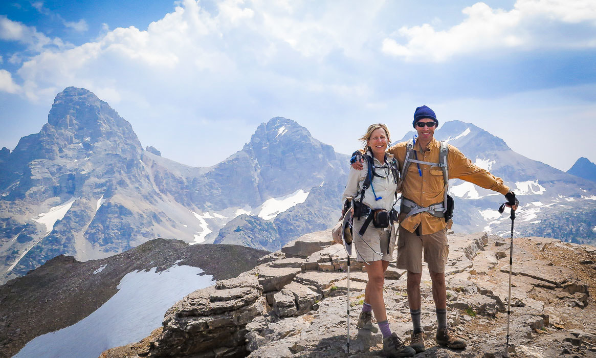
View of the Grand Teton, Middle Teton, and South Teton from summit of Table Mountain, 11,106 feet
Trip Stats for North Teton (Huckleberry)/Face loop:
  • Distance:  ascend North Teton Trail (Huckleberry Trail) #024 (6.5 miles), descend North Teton Trail and Face Trail  #029 (4 miles) = 10.5 miles round-trip.   Face Trail is 2.6 miles long.  Loop can be done in reverse.
  • Elevation:  4,100 feet:  Teton Canyon Trailhead is at 7,000 feet; Table Mountain summit = 11, 106 feet.
  • Difficulty:  Moderate - Strenuous Class 1, with brief easy scramble over summit rocks.
  • Location:  most of this hike is in the Jedediah  Smith Wilderness.  Table Mountain is located on the border between this wilderness and Grand Teton National Park.  Table Mountain:  43°44'48" N  110°51'07" W
  • Maps:  Trails Illustrated Topographic Map #202 - Grand Teton National Park, Topozone topographic map of Jedediah Smith Wilderness.
  • Driving Directions:  From Main Street in Driggs, Idaho, drive east 6.3 miles on East Little Avenue/Ski Hill Road.  You will pass through Alta, Wyoming.  Turn right onto Teton Canyon Road and travel this gravel road for 4 miles to Teton Canyon trailhead, crossing 2 bridges just before trailhead.  A large sign labeled North Teton Trail #024 located at edge of parking lot.
  • Hike Directions:   We ascended the more gradual  North Teton Trail #024 (Huckleberry Trail) that treks along the North Fork of Teton Creek to intersection with the Face Trail #029 at 5.0 miles.  At intersection, bear left (east) toward the summit.  Hike 1.5 miles to summit, emerging out of tree line onto ridge.  We descended Huckleberry Trail #024 to intersection and continued straight (west) on The Face Trail #029 for 2.6 miles to the Teton Canyon trailheads.  The Face Trail terminates near the South Teton trailhead, south of the North Teton trailhead.
  • CAUTION:  Frequent afternoon thunderstorms - approach ridge is exposed for the last 1.5 miles to summit.  Consider starting hike early to be able to get off exposed portion by early afternoon.
  • Geology:   The Great Unconformity between the 2.7 billion year old Archean gneiss (cliffs) and overlying Cambrian Flathead Sandstone, made up of beach sands deposited 540 million years ago, is seen as two distinct layers on the bench of Table Mountain.  The Buck Mountain Fault and Teton Fault, parallel to each other, created the uplifted wedge that contains the tallest peaks of the Teton Mountain Range including the Grand Teton and Mount Owen.  The Buck Mountain Fault runs between Table Mountain and the Teton Mountain Range.
                         "There are only three sports:  bullfighting, motor racing, and mountaineering; all the rest are merely games."
                                    -  Ernest Hemingway
Picture
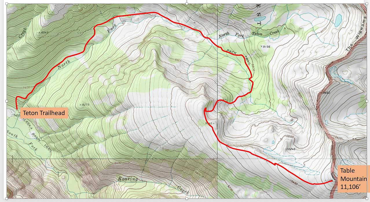
North Teton Trail (Huckleberry Trail) from North Teton Trailhead to Table Mountain summit
click on map for full Topozone map
Picture
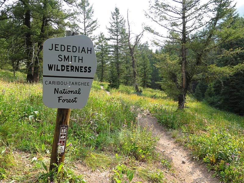
Jedediah Smith Wilderness boundary about 1 mile into hike on North Teton Trail #024
Fred and I hiked the amazing North Teton trail to its spectacular summit this past August, at the suggestion of a friend who found out we were going to the "Idaho side of the Tetons".   We didn't want to see the  crowds of people in Grand Teton National Park, so we hiked out of Driggs, Idaho.  

At the end of Teton Canyon Road, 10.5 miles from downtown Driggs, Idaho there are two trailheads.  The trail from the North Teton trailhead (North Teton trail, AKA Huckleberry trail) goes to Table Mountain, and the trail from the South Teton trailhead goes to Alaska Basin (another stunning hike where we saw a moose).  The Face trail is accessed between these two trailheads.  Some hikers ascend via the Face Trail; it is a more direct but steeper, unmaintained route to Table Mountain.  We descended via Face Trail but I would not do that again because it is very steep with loose rocks and shallow switchbacks, and my toes got really sore pushing against the front of my boots!

If you want to avoid Face Trail, you can do an out-and-back hike on North Teton Trail for a total of 13 miles.

This hike gets more spectacular with nearly every step.  As with most summit hikes, it starts out in thick forest canopy, hiking along North Fork Teton Creek.  Multi-colored blankets of wildflowers among bright green grasses and shrubs covered the lower slopes of the U-shaped glacially-carved valley we walked through.  Peaks towered above us as tall limestone cliffs seemed to surround, dominating much of the horizon.  There had to be a break in those walls to get us on top of the ridge overlooking the valley we had ascended.
Picture
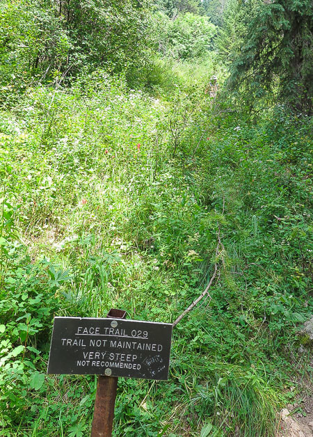
Face Trail trailhead located between North Teton and South Teton trailheads at the end of Teton Canyon Road
Picture
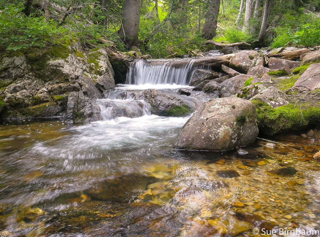
North Teton Trail (Huckleberry Trail) goes along North Fork Teton Creek
Picture
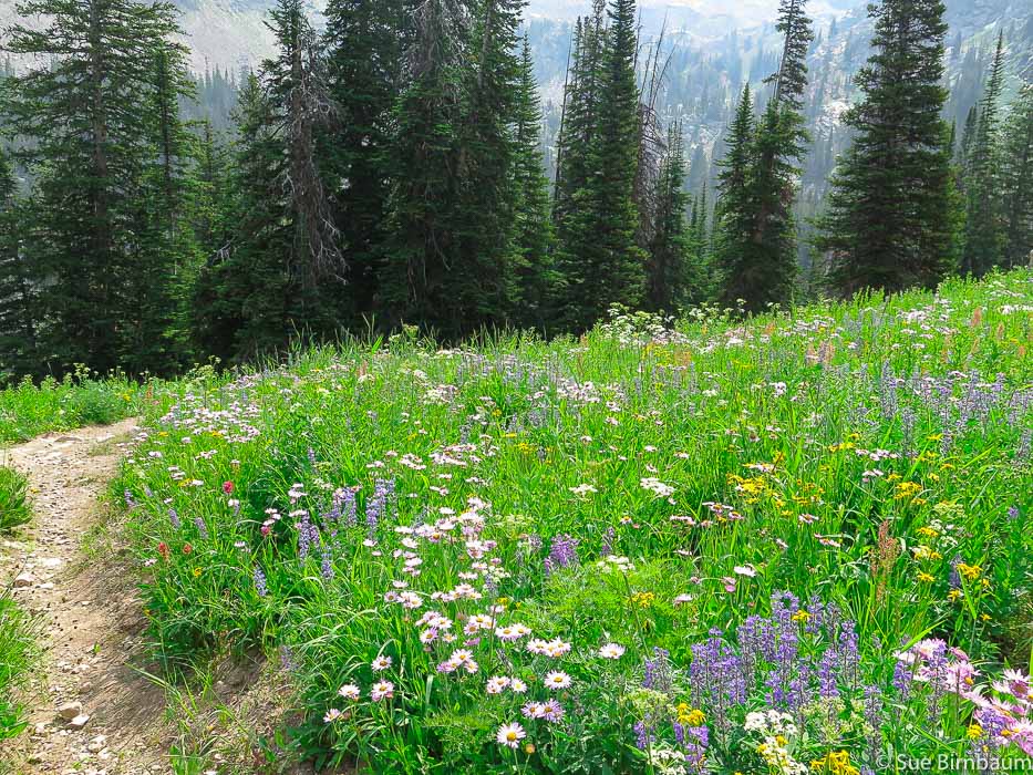
North Teton Trail (Huckleberry Trail) - Jedediah Smith Wilderness
North Teton Trail leaves the North Fork Teton Creek at 8,400 feet, then heads southward through the steep basin and toward a break in the cliffs. The trail then switch-backs to the ridge, climbing ~ 1,500 feet through basin and up switchbacks in about 1.5 miles.  The ridge is at 9,900 feet.  Table Mountain  looks like an altar facing the immense and looming Grand Teton.  After the steep ascent from basin to ridge, the trail takes a turn southeastward with its sights straight toward the summit, passing very close to the cliff edge for one last view of the magnificent basin just ascended.  Just 1,200 more vertical feet to climb to the summit!
Picture
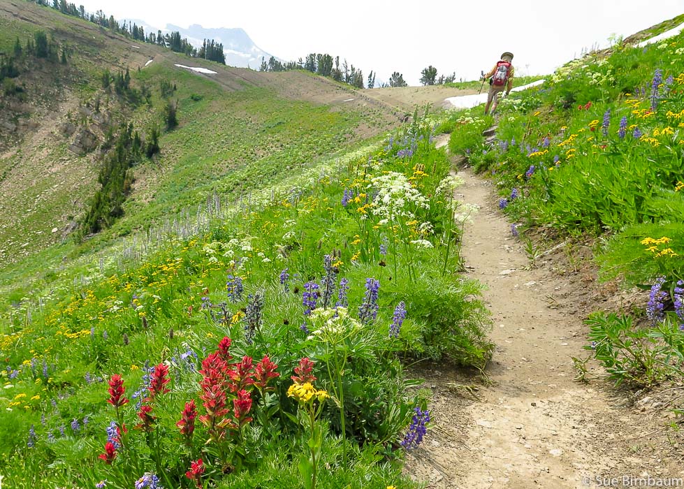
One of the switchbacks that climbs out of basin in a southwestward direction to top-off at ridge (~ 9,900 feet) and nearby intersection with Face Trail
Picture
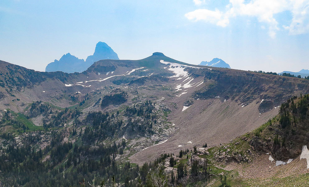
Table Mountain facing the Grand Teton as viewed from switchbacks out of basin
Picture
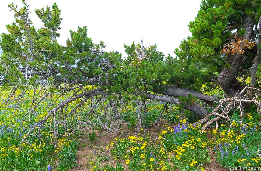
Along  North Teton Trail (AKA Huckleberry Trail) on ridge near intersection with Face Trail  ~ 10,000 feet
After climbing out of the basin onto the ridge, the trail heads straight toward the summit, surrounded by wildflowers the entire way until the summit block.  Table Mountain looms ahead and it seems to take forever for it to get closer.  The juxtaposition of the tips of the Grand Teton and Mt. Owen rising behind the low, broad and grounded bench of Table Mountain is a rare sight.  This is a great example of Earth's awesome forces; a relatively "young" fault (Buck Mountain Fault) raising old rocks higher than newer rocks in such a dramatic manner.  After passing through pines and purple lupines, the trail suddenly opens up to a vast and high open meadow dotted with swaying white bistorts (my favorite wildflower).   We saw people the size of small dots on the final incline to the summit.  With legs burning, we made our way up this incline to the cool, breezy summit scrambling through a cut in the sharp rocks.  A few more steps along the flat summit, and then WOW!  The earth quickly drops below you as you stand on a precipice (2,300-foot drop in this case), and the world opens up to make you feel like a speck in the middle of it.  But this is no "ordinary" summit because you come face to face with the enormity of the Tetons, making you feel even smaller.  The Grand is so close you can see its ledges and walls.  You have worked to claim your lofty space, but you gaze at a space loftier than the small patch of Earth on which you stand.
Picture
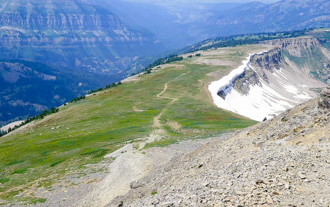
Looking down from summit at the final approach to Table Mountain with Roaring Creek and Alaska Basin Trail to the left of ridge (southwest)
Picture
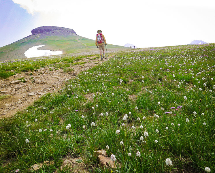
Hiking through a sea of American bistort (Bistorta bistortoides) and purple aster on the final stretch to Table Mountain
Picture
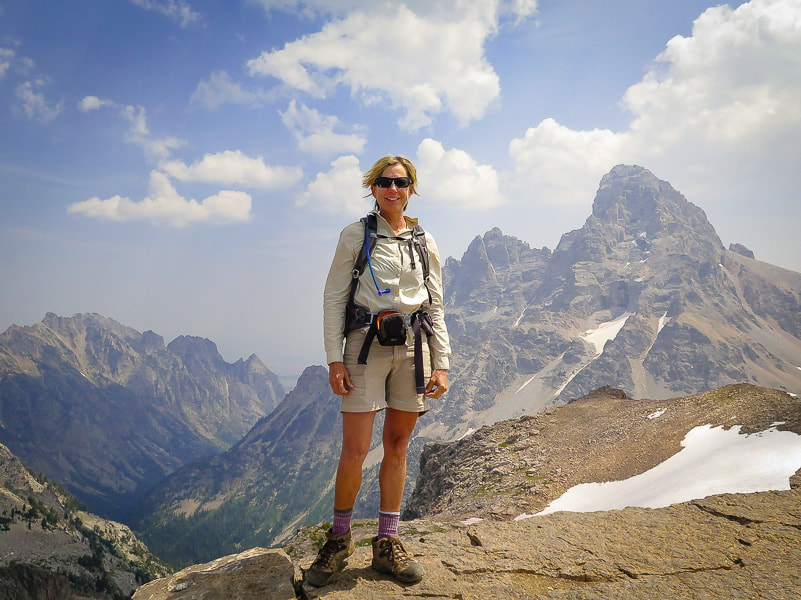
Sue on summit of Table Mountain, 11,106 feet with Grand Teton and Mt. Owen in background
Picture
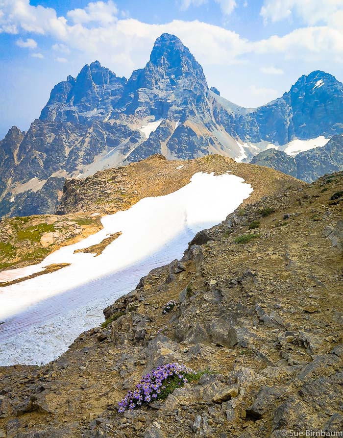
Summit of Table Mountain 
Peaks left to right:  Mt. Owen, Grand Teton, Middle Teton
Fellow hikers lingered at the summit.  We savored the experience, too, and then saw weather coming in from the southwest.  We decided to get off the exposed rock, and on our way down, a lightning storm raged over another ridge.  We took the Face Trail # 029 at the intersection with North Teton Trail which saved us time and mileage.  Face Trail starts out with gentle decline and ends with a quadricep workout down the very steep pitch with loose rocks.  At the end of this trail, a metal sign reads "Face Trail 029 - Very Steep - Not Recommended".   Next time, I would go up Face Trail and down North Teton Trail.  Or skip Face Trail altogether.

The next day, we hiked 5 miles up Alaska Basin Trail with millions of wildflowers.
Picture
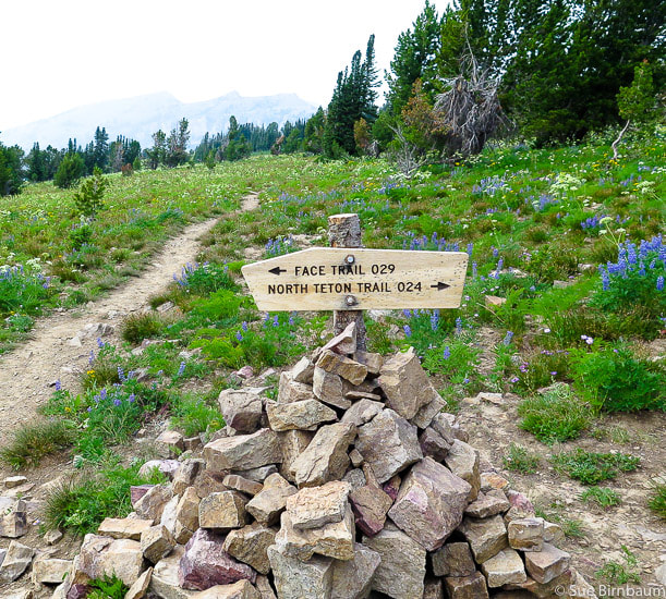
Intersection of North Teton Trail with Face Trail ~ 1.5 miles from summit
Face Trail is ~ 2.6 miles shorter on the way down but much steeper!
References:
Miller, M.B. (2012, August 2).  Great Unconformity in the Teton Range, Wyoming. [Blog Post]. Retrieved from - https://geologictimepics.com/2012/04/

Ortenburger, L. N., and Jackson, R.G.  (1996)  A Climbers Guide to the Teton Range, 3rd Edition.   (Click on title for link).
6 Comments
Linda link
10/30/2018 08:31:46 am

Gazing at those peaks from the ridgeline during Targhee ski trips, I've often drooled at the thought of hiking that region. As usual, your photos are stunning.

Reply
Sue link
10/31/2018 08:23:52 am

Thank-you for your comment - we are lucky to have access to such beauty. I have been to Targhee once skiing and remember seeing the Tetons from the top of the ski run! So much to do, so little time!
Love your blog posts on rangewriter.blog - I keep waiting for the time Yry will get back to Wyoming........

Reply
essays uk link
5/7/2019 01:38:10 am

If you are into hiking, there are thousands of mountains that you can climb up to prove your greatness in hiking. I guess, Caribou-Targhee National Forest will give you an experiencer that you will never forget. Based on how you have narrated your hiking story here, It wasn't really easy. There were huge challenges that may have stopped you from the hike, but you were dedicated to reach the peak. No amount of challenge can ever back you down! Caribou-Targhee National Forest should be part of everyone's hiking bucket list!

Reply
Sue link
5/9/2019 06:03:27 pm

Thank-you for your comments - they are very accurate when you talk about the challenge of this hike. And I agree this hike should be a part of everyone's bucket list - in fact, there were a lot of people on the trail that were doing the hike in their own time, not trying to do it fast, but to enjoy it and respect the gorgeous wilderness they were hiking in. That is what's special about hiking - sharing beauty and our wilderness!

Reply
Jordan link
4/21/2022 01:04:56 am

am a travel buddy and I like to travel different places. It is always a
great experience and it is to be very nice . I visit many places in last two years.

Reply
Sue link
4/21/2022 08:07:49 pm

Thanks for the comment - keep on exploring the American West and keep on having great experiences - you will always remember them.

Reply


Leave a Reply.

    Categories

    All
    Arizona Hikes
    California Desert Hiking
    Idaho Summits
    Nevada Hikes
    Snowshoe Hikes
    Southern Utah Hikes/Bikes

    Complete list of Hikes/Bikes on HOME page
    Picture
    Sue and Fred
    Picture

    About this blog

    Exploration documentaries          –  "explorumentaries"  list trip stats and highlights of each hike or bike ride, often with some interesting history or geology.  Years ago, I wrote these for friends and family to let them know what my husband, Fred and I were up to on weekends, and also to showcase the incredible land of the west.  

    To Subscribe to Explorumentary adventure blog and receive new posts by email:

    submit
    Picture
    Happy Spring!
    Picture

    About the Author
    Sue Birnbaum

    A  trip to Jumbo Rocks Campground in Joshua Tree National Monument 38 years ago sparked my passion for hiking, exploring, and learning about desert ecosystems.  For the past 25 years, my husband Fred and I have explored the American West together; we love this land and I hope to inspire you to get out and explore through my photographs and trip descriptions.
    In 1992, Ray Wilson and I conceived the first Cactus to Clouds hike which climbs over 10,000 feet in one day to the summit of Mt. San Jacinto near Palm Springs, California.
    CACTUS TO CLOUDS HIKE 
    READ MORE
    ABOUT SUE

    Archives

    February 2023
    January 2023
    December 2022
    November 2022
    October 2022
    September 2022
    August 2022
    July 2022
    June 2022
    May 2022
    April 2022
    February 2022
    January 2022
    December 2021
    November 2021
    October 2021
    August 2021
    July 2021
    May 2021
    March 2021
    February 2021
    January 2021
    November 2020
    October 2020
    August 2020
    July 2020
    June 2020
    April 2020
    March 2020
    February 2020
    January 2020
    November 2019
    October 2019
    September 2019
    August 2019
    July 2019
    June 2019
    May 2019
    April 2019
    February 2019
    December 2018
    November 2018
    October 2018
    September 2018
    July 2018
    June 2018
    May 2018
    April 2018
    March 2018
    February 2018
    January 2018
    December 2017
    November 2017
    October 2017
    September 2017
    August 2017
    July 2017
    June 2017
    April 2017
    February 2017
    November 2013
    August 2013
    July 2013

    Some of my favorite websites:
    Awkward Botany
    ​citizen botany for the phytocurious

    Bird and Hike

    ​"Intended to encourage people to visit, learn about, and fall in love with the desert."
    ​

    Draw and Shoot
    Beautiful Photography

    Earthline: The American West
    Debra "writes to extol our beloved Earth." Detailed hike info, excellently written.
    ​

    Geologypics.com
    Geology and Geologic Time through Photographs

    Glenn Suokko
    Vermont artist's paintings "inspired by a place based on the land .... drawn to painting the representation and abstraction of nature."

    In the Company of Plants and Rocks
    ​A natural history blog about botany, plant ecology, and geology.

    Nature's Depths

    Walking through nature with John Palka, a neuroscientist who loves plants and ponders big questions

    Rangewriter - What Comes Next?
    ​With excellent writing, Linda tells the story of her unique mother's life including WWII era; with beautiful photographs.

    SeekingLost - Hiking and Backpacking Adventures.

    Stav Is Lost- Unconventional, out-of-the way hikes in the American West.


    Uprooted Magnolia
    ​Leah Yetter's beautiful "photo journal on life, love, and the spirit of Wyoming."
HOME

Cactus to Clouds Hike
More Quotes
HIKES BY STATE

Idaho Hikes
Utah Hikes/Bikes
​Arizona Hikes
​California Desert Hikes
​Wyoming Hikes
​Nevada Hikes

BLOGS

Adventure Blog
Women and the Land
GEAR REVIEWS
FIT AFTER 50
Fred Birnbaum
Dave Brasuell
Bus' Little Black Book
​Mike Carlson
​Ray Wilson
​Marcia Bondy
Bryan Krouse
​Maria Keezer
​Tim Clemens
​Doug Traubel
​Brian Holgate
​
Becky Borczon Blake
​Jennifer Cera and
​Sue Birnbaum

​Vance Powell
​Boise Cross Fit Masters Ladies
​Vickie Kearney

GALLERY

Desert Plants
Nature
Earth + Sky
Urban
Water
Patriot 
​Orchids
Boise
​
  ABOUT
    Contact

​
© 2017 - 2023 by Sue Birnbaum.  Photos on this website are the sole property of Sue Birnbaum unless otherwise indicated.  Please receive permission before publishing my trip reports and photos.
I try my best to be accurate with my hike descriptions; please research your adventures, always bring a map and compass and know how to read them, be prepared!  All of these hikes can be dangerous; hike at your own risk.  ALWAYS carry the Ten Essentials with you on hikes. 
​Please feel free to contact me with comments or questions, or if you see any errors that need attention.
Thank-you for stopping by!


EXPLORUMENTARY.com
  • Home
    • Cactus to Clouds Hike
    • More Quotes
    • Ann Zwinger Quotes
    • Mary Oliver Poems
  • Hikes by State
    • Idaho
    • Southern Utah
    • Arizona
    • California Desert
    • Nevada
    • Wyoming
  • BLOGS
    • Adventure Blog
    • Women and the Land
  • GALLERY
    • DESERT PLANTS >
      • Beavertail cactus
      • Brittlebush
      • Christmas Cactus
      • Arizona Barrel Cactus
      • Parry's penstemon
      • Agave
      • Arizona Rainbow Hedgehog
      • Claret Cup Hedgehog
      • Desert Agave
      • Palmer's Penstemon
      • Silver Cholla
      • Cristate Saguaro
      • Indian Paintbrush
      • Ocotillo
      • Santa Rita Prickly Pear
      • Spiny Cliffbrake
      • California Barrel Cactus
      • Engelmann Prickly Pear
      • Velvet Mesquite
      • Joshua Tree
      • Buckhorn Cholla
      • Hedgehog Cactus
      • Fishhook cactus
      • Thompson's Woolly Locoweed
    • NATURE
    • BOISE
    • EARTH + SKY
    • URBAN
    • WATER
    • PATRIOT
    • ORCHIDS
  • Fit After 50
    • Brian Holgate
    • Fred Birnbaum
    • Dave Brasuell
    • Bus' Little Black Book
    • Mike Carlson
    • Ray Wilson
    • Bryan Krouse
    • Vickie Kearney
    • Maria Keezer
    • DOUG TRAUBEL
    • Boise Cross Fit Masters Ladies
    • Tim Clemens
    • Marcia Bondy
    • Becky Borczon Blake >
      • Becky B Downtown
    • Jennifer Cera and Sue Birnbaum
    • Dave Brasuell
    • Vance Powell
  • About
    • CONTACT