Golden Cathedral Map and Hiking Directions - Glen Canyon National Recreation Area
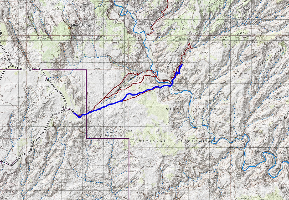
Our route (blue line) on the Beeline Trail out and back: beginning at Egypt Trailhead (left), descending cleft in butte, walking across Egypt Bench, crossing Escalante River, and walking up Neon Canyon.
The dark red lines show alternate ways of hiking to Neon Canyon. The top line is the Standard Golden Cathedral Trail.
Map of our loop hike using Beeline and Golden Cathedral on a previous hike
The dark red lines show alternate ways of hiking to Neon Canyon. The top line is the Standard Golden Cathedral Trail.
Map of our loop hike using Beeline and Golden Cathedral on a previous hike
Beeline Trail out and Back
Egypt Trailhead: 37.59309 -111.21829 elevation 5,635'.
Distance/Elevation Gain: 10 miles round trip with ~ 1,200' gain.
Difficulty: minimal - moderate effort, trail alternates between slickrock and sand, may or may not be cairns, navigation moderately challenging, fragments of trails, experience with route-finding essential.
Maps/Apps: National Geographic Canyons of the Escalante, Grand Staircase-Escalante MN, AllTrails app.
Considerations:
- the southern Beeline Trail heads straight to Neon Canyon and Point 5,270, and entails only one Escalante River crossing. The northern route that drops into Fence Canyon requires more river crossings/walking in river and finding your way through the brush of the river lowlands.
- Know weather forecast: flash flood hazard in Neon Canyon. Escalante Interagency Visitor Center (road conditions).
Hiking directions
Driving Directions: 4 WD with moderate clearance best.
- From trailhead parking and register, look east-northeast toward a large undulating bench bordered by Escalante River and Fence Canyon. Find the round dome (Point 5,270) on the other side of Escalante River, ~ 4 miles away. Neon Canyon's opening is just in front of (to the west) of this dome, the main landmark to aim to.
- The Beeline Route hikes in a straight line to Point 5,270.
- From trailhead, find trail that heads down into the bowl, through the dark brown rocks of the Carmel Formation that are scattered haphazardly. This is a good reference point for the return hike.
- Descend from Egypt Trailhead to base of bowl: 0 - 0.7 miles. Down, off the plateau, down slickrock, avoiding steep pitches in an easterly direction. Off of the plateau, the trail alternates between some slickrock and sandy spots, across Egypt Bench.
- Cross Egypt Bench to Escalante River: 0.7 - 3.8 miles.
- Neon Canyon to Golden Cathedral: 3.8 - 5.0 miles.
- Look for the dark brown scattered rocks on the rim leading to the plateau where the trailhead is. Occasional cairns mark the way; for the most part, head over alternating slick rock and sand pockets to the slickrock bowl you descended.
Driving Directions: 4 WD with moderate clearance best.
- From the town of Escalante, drive east on Hwy 12 and turn south onto Hole-In-the-Rock Road.
- Drive 16.7 miles to a sign labeled "Egypt -10 miles" and turn left (east). Zero out your odometer.
- At 2.8 miles continue straight.
- At 3.5 miles, cross Twentyfive Mile wash. This is often wet, but in August it was dry.
- At 9.2 miles pass over culvert that marks the Egypt 3 slot canyon.
- at 9.5 miles and an intersection, turn right.
- At 10 miles, park in a large circular lot.