Cosmic Ashtray via Volcano Trail
Hike Directions
Hike Directions
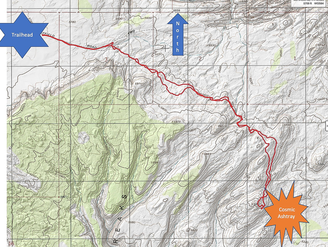
The trailhead to Cosmic Ashtray (Inselberg Pit) begins off of Old Sheffield Road/Spencer Flat Road (northwest).
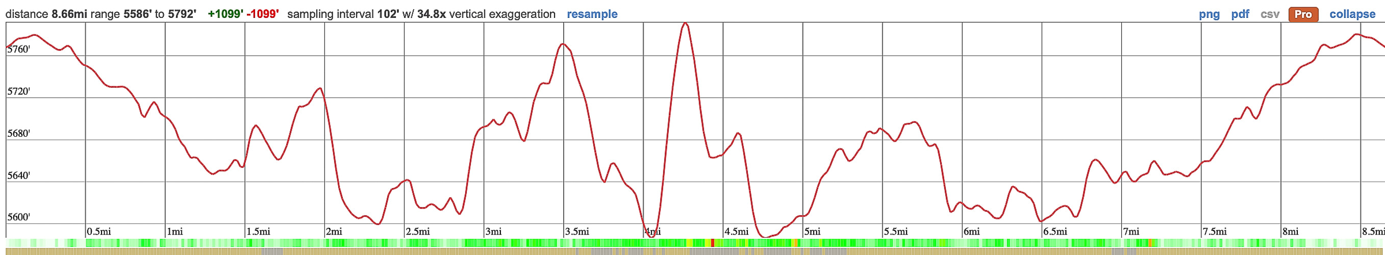
The Volcano Trail extends southeast, contouring the cliffs of the Red Breaks to reach the Cosmic Ashtray in four miles.
The Volcano Trail extends southeast, contouring the cliffs of the Red Breaks to reach the Cosmic Ashtray in four miles.
Trailhead: 37.71026, -111.35868. Elevation = 5,770'.
Difficulty: Moderate effort, off-trail, cairns to mark route may or may not be present; navigation is challenging requiring you to have prior experience.
Maps and Apps: National Geographic Canyons of the Escalante - Grand Staircase-Escalante NM. AllTrails app, Topo Maps U.S. app.
**Option to bring a 60' rope to enter/exit pit sand.
Escalante Interagency Visitors Center (Road conditions)
Driving:
- Take Spencer Flat Road off Highway 12 between Escalante and Boulder, Utah, turning at mile marker 70 south onto dirt.
- Zero-out your trip meter. At 5.8 miles in Big Spencer Flat, the main road goes right/south. Take the left fork trending east. The road narrows to a two-track and reaches a large parking area with sign at 6.9 miles.
- Parts of the road may be sandy. We like to take our pick-up truck that has high clearance. A 2 WD passenger car would need good clearance.
- The trailhead is reached after a turn-off from Spencer Flat Road/Old Sheffield Road. Spencer Flat turns south and divides from Old Sheffield Road, which continues eastward.
- Hike at first on the continuation of Old Sheffield jeep trail, which quickly turns into a sandy 2-track, then into a wide trail, heading east/southeast.
- At 0.6 miles from trailhead, turn southeast off of road to walk along the base of the Red Breaks (cliffs). We saw a trail through sand/sandstone intervals with cairns marking the trail.
- At ~ 1.3 miles, sand ends. Walk on rolling sandstone, creased with ravines the rest of the way to Cosmic Ashtray, occasional cairns marking the way.
- At 4.1 miles, we followed cairns that lead straight up a knob, looked over the side of it and saw Cosmic Ashtray. This is a great vantage point to see the entire sand dune, including the sand behind the rock pedestal in the middle of the dune. We then hiked back down that rise and found the north entrance to the Ashtray.
- I have heard that you can tie a rope around a shrub to help lower into the pit. There are a few shallow steps carved into the sandstone that lead into the pit. I had also heard there was hardware to tie into but we didn't see that.
- We headed back more or less the same way. The advantage of hiking lower on the slope is that you avoid occasional deep ravines between sandstone knobs.